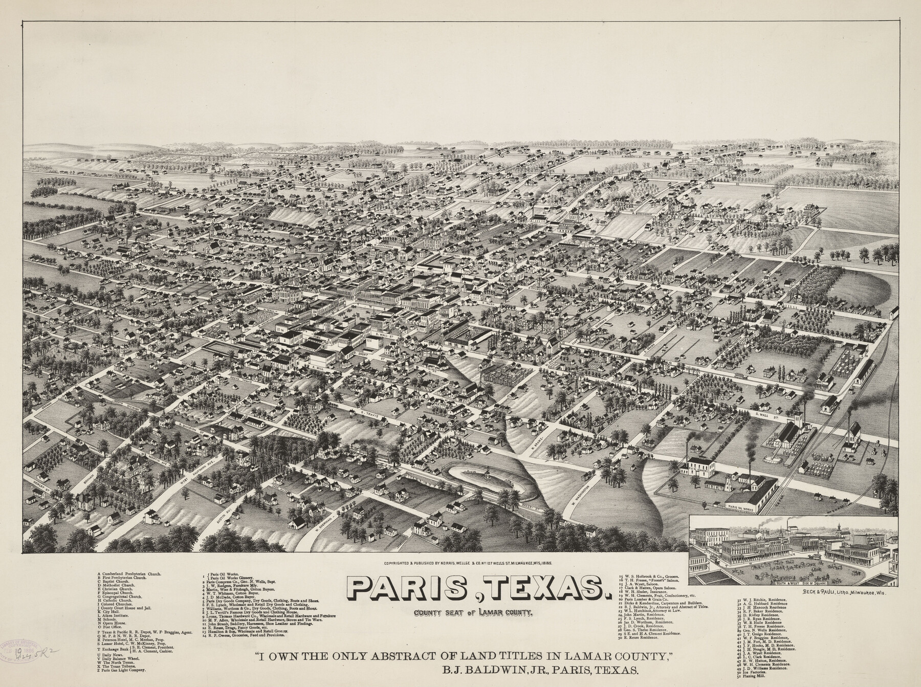
Paris, Texas, County Seat of Lamar County
-
Map/Doc
89201
-
Collection
Non-GLO Digital Images
-
Object Dates
1885 (Creation Date)
-
People and Organizations
Norris, Wellge and Company (Publisher)
Beck and Pauli Lithograph (Printer)
-
Counties
Lamar
-
Subjects
Bird's Eye View City Pictorial
-
Height x Width
17.8 x 23.8 inches
45.2 x 60.5 cm
-
Comments
Bird's Eye View map. Public Domain image obtained from Wikimedia Commons.
Part of: Non-GLO Digital Images

Bird's Eye View of San Marcos, Hays County, Texas

Print $20.00
Bird's Eye View of San Marcos, Hays County, Texas
1881
Size 18.5 x 28.3 inches
Map/Doc 89205
[Movements & Objectives of the 143rd & 144th Infantry & 133rd Machine Gun Battalion on October 8-9, 1918, Appendix E, No. 4] - Verso
![94134, [Movements & Objectives of the 143rd & 144th Infantry & 133rd Machine Gun Battalion on October 8-9, 1918, Appendix E, No. 4] - Verso, Non-GLO Digital Images](https://historictexasmaps.com/wmedia_w700/maps/94134-1.tif.jpg)
Print $20.00
[Movements & Objectives of the 143rd & 144th Infantry & 133rd Machine Gun Battalion on October 8-9, 1918, Appendix E, No. 4] - Verso
1918
Size 21.5 x 20.0 inches
Map/Doc 94134
Map of the State of Texas Engraved to Illustrate Mitchell's School and Family Geography

Print $20.00
Map of the State of Texas Engraved to Illustrate Mitchell's School and Family Geography
1846
Size 12.0 x 9.6 inches
Map/Doc 87902
Map of Texas with Parts of the Adjoining States

Print $20.00
Map of Texas with Parts of the Adjoining States
1836
Size 29.8 x 24.1 inches
Map/Doc 93963
Bird's Eye View of Abilene, Taylor County, Texas

Print $20.00
Bird's Eye View of Abilene, Taylor County, Texas
1883
Size 23.6 x 30.7 inches
Map/Doc 89071
Plano, Collin County, Texas

Print $20.00
Plano, Collin County, Texas
1891
Size 12.8 x 22.6 inches
Map/Doc 93758
Mapa de Texas con partes de los Estados Adyacentes

Mapa de Texas con partes de los Estados Adyacentes
1832
Size 6.8 x 5.7 inches
Map/Doc 94560
The Official Map of the City of El Paso, State of Texas

Print $20.00
The Official Map of the City of El Paso, State of Texas
1889
Size 41.9 x 46.2 inches
Map/Doc 89618
El Nuevo México y Tierras Adyacentes Levantado para la Demarcación de los Límites de los Dominios Españoles y de los Estados Unidos

El Nuevo México y Tierras Adyacentes Levantado para la Demarcación de los Límites de los Dominios Españoles y de los Estados Unidos
1811
Size 9.4 x 12.6 inches
Map/Doc 94445
Karte von Afrika

Print $20.00
- Digital $50.00
Karte von Afrika
1888
Size 28.9 x 35.5 inches
Map/Doc 97503
Bird's Eye View of Schulenburg, Fayette County, Texas

Print $20.00
Bird's Eye View of Schulenburg, Fayette County, Texas
1881
Size 18.6 x 31.0 inches
Map/Doc 89206
You may also like
Concho County Working Sketch 7

Print $20.00
- Digital $50.00
Concho County Working Sketch 7
1948
Size 44.3 x 46.0 inches
Map/Doc 68189
Flight Mission No. DQN-7K, Frame 34, Calhoun County

Print $20.00
- Digital $50.00
Flight Mission No. DQN-7K, Frame 34, Calhoun County
1953
Size 18.5 x 22.1 inches
Map/Doc 84472
Umbarger in Randall County, Texas

Print $20.00
- Digital $50.00
Umbarger in Randall County, Texas
1905
Size 31.9 x 30.8 inches
Map/Doc 92158
Harris County Sketch File F

Print $4.00
- Digital $50.00
Harris County Sketch File F
1860
Size 10.1 x 5.1 inches
Map/Doc 25317
Presidio County Rolled Sketch 57

Print $20.00
- Digital $50.00
Presidio County Rolled Sketch 57
1915
Size 22.8 x 17.3 inches
Map/Doc 7350
Flight Mission No. CRC-4R, Frame 101, Chambers County

Print $20.00
- Digital $50.00
Flight Mission No. CRC-4R, Frame 101, Chambers County
1956
Size 18.6 x 22.4 inches
Map/Doc 84898
Webb County Rolled Sketch 50

Print $20.00
- Digital $50.00
Webb County Rolled Sketch 50
1943
Size 38.2 x 42.6 inches
Map/Doc 10125
Terrell County Sketch File 38

Print $6.00
- Digital $50.00
Terrell County Sketch File 38
1987
Size 11.3 x 8.8 inches
Map/Doc 38001
Map of Jack County

Print $20.00
- Digital $50.00
Map of Jack County
1896
Size 43.6 x 38.9 inches
Map/Doc 66877
Gregg County Rolled Sketch 22

Print $20.00
- Digital $50.00
Gregg County Rolled Sketch 22
1934
Size 30.0 x 41.6 inches
Map/Doc 9073
Fisher County Working Sketch 18

Print $20.00
- Digital $50.00
Fisher County Working Sketch 18
1941
Size 24.7 x 16.6 inches
Map/Doc 69152
Glasscock County Rolled Sketch 4

Print $20.00
- Digital $50.00
Glasscock County Rolled Sketch 4
1928
Size 26.7 x 20.9 inches
Map/Doc 6015