Galveston County Rolled Sketch DB
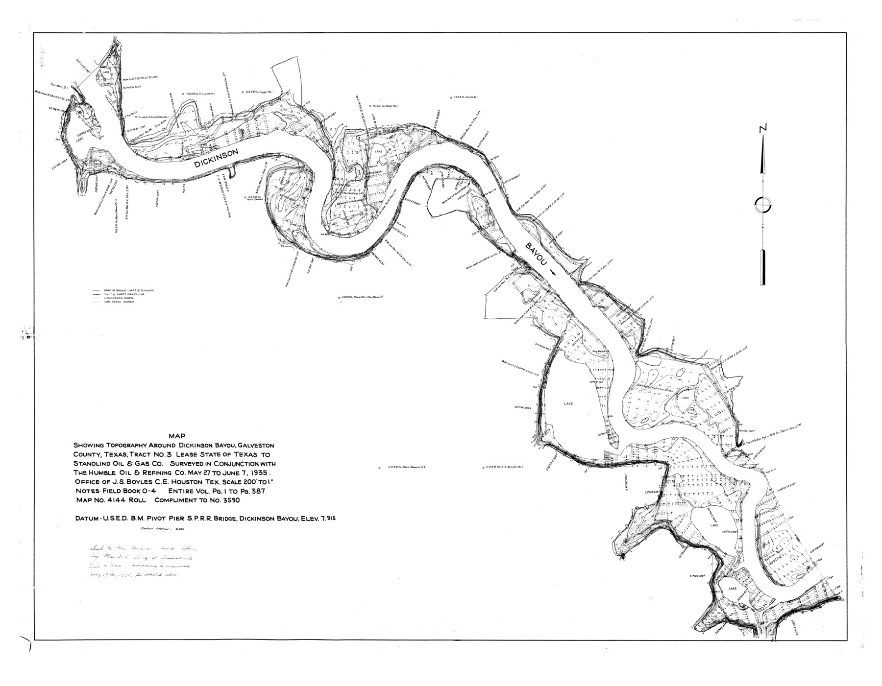
Map showing topography around Dickinson Bayou, Galveston County, Texas tract no. 3 lease State of Texas to Stanolind Oil & Gas Co.
-
Map/Doc
9854
-
Collection
General Map Collection
-
Object Dates
1935/7/17 (File Date)
1935/6/7 (Survey Date)
-
People and Organizations
J.S. Boyles (Surveyor/Engineer)
-
Counties
Galveston
-
Subjects
Surveying Rolled Sketch
-
Height x Width
37.0 x 47.5 inches
94.0 x 120.7 cm
-
Scale
1" = 200 feet
Part of: General Map Collection
Travis County Sketch File 53

Print $6.00
- Digital $50.00
Travis County Sketch File 53
1945
Size 14.2 x 9.0 inches
Map/Doc 38395
Rockwall County Working Sketch 4

Print $20.00
- Digital $50.00
Rockwall County Working Sketch 4
1966
Size 34.9 x 28.9 inches
Map/Doc 63596
Flight Mission No. DAG-14K, Frame 143, Matagorda County

Print $20.00
- Digital $50.00
Flight Mission No. DAG-14K, Frame 143, Matagorda County
1952
Size 16.4 x 16.4 inches
Map/Doc 86310
Shelby County Sketch File 5

Print $22.00
- Digital $50.00
Shelby County Sketch File 5
Size 8.4 x 12.1 inches
Map/Doc 36599
Map of Matagorda County

Print $20.00
- Digital $50.00
Map of Matagorda County
1865
Size 32.8 x 28.4 inches
Map/Doc 3843
Bandera County Sketch File 36

Print $6.00
- Digital $50.00
Bandera County Sketch File 36
Size 11.4 x 8.9 inches
Map/Doc 14034
[Beaumont, Sour Lake and Western Ry. Right of Way and Alignment - Frisco]
![64129, [Beaumont, Sour Lake and Western Ry. Right of Way and Alignment - Frisco], General Map Collection](https://historictexasmaps.com/wmedia_w700/maps/64129.tif.jpg)
Print $20.00
- Digital $50.00
[Beaumont, Sour Lake and Western Ry. Right of Way and Alignment - Frisco]
1910
Size 20.1 x 45.9 inches
Map/Doc 64129
Flight Mission No. DIX-10P, Frame 75, Aransas County

Print $20.00
- Digital $50.00
Flight Mission No. DIX-10P, Frame 75, Aransas County
1956
Size 18.6 x 22.3 inches
Map/Doc 83936
Lee County Working Sketch 22

Print $20.00
- Digital $50.00
Lee County Working Sketch 22
2010
Size 29.2 x 29.6 inches
Map/Doc 89271
Washington County Working Sketch Graphic Index

Print $20.00
- Digital $50.00
Washington County Working Sketch Graphic Index
1976
Size 31.3 x 46.8 inches
Map/Doc 76733
Zapata County Working Sketch 23

Print $20.00
- Digital $50.00
Zapata County Working Sketch 23
1982
Size 45.8 x 42.9 inches
Map/Doc 62074
Crockett County Rolled Sketch 84

Print $20.00
- Digital $50.00
Crockett County Rolled Sketch 84
1961
Size 31.9 x 25.2 inches
Map/Doc 5624
You may also like
Cuadro Geografico y Estadistico

Print $20.00
- Digital $50.00
Cuadro Geografico y Estadistico
Size 23.1 x 30.9 inches
Map/Doc 96982
Brooks County Rolled Sketch 14

Print $20.00
- Digital $50.00
Brooks County Rolled Sketch 14
Size 28.4 x 32.8 inches
Map/Doc 5339
Brazoria County Rolled Sketch 49

Print $20.00
- Digital $50.00
Brazoria County Rolled Sketch 49
1948
Size 24.1 x 36.5 inches
Map/Doc 5186

Anderson County Sketch File 9

Print $8.00
- Digital $50.00
Anderson County Sketch File 9
Size 12.5 x 8.2 inches
Map/Doc 12761
[E. L. & R. R. RR. Blks. 9 & 10]
![90123, [E. L. & R. R. RR. Blks. 9 & 10], Twichell Survey Records](https://historictexasmaps.com/wmedia_w700/maps/90123-1.tif.jpg)
Print $2.00
- Digital $50.00
[E. L. & R. R. RR. Blks. 9 & 10]
Size 8.7 x 11.3 inches
Map/Doc 90123
Kendall County Rolled Sketch 3

Print $9.00
- Digital $50.00
Kendall County Rolled Sketch 3
1858
Size 10.0 x 15.3 inches
Map/Doc 46424
[Northwest 1/4 of County]
![90824, [Northwest 1/4 of County], Twichell Survey Records](https://historictexasmaps.com/wmedia_w700/maps/90824-2.tif.jpg)
Print $20.00
- Digital $50.00
[Northwest 1/4 of County]
Size 19.1 x 23.3 inches
Map/Doc 90824
Val Verde County Sketch File 15a

Print $40.00
- Digital $50.00
Val Verde County Sketch File 15a
1885
Size 15.8 x 12.7 inches
Map/Doc 39217
McMullen County Working Sketch 42

Print $20.00
- Digital $50.00
McMullen County Working Sketch 42
1980
Size 35.6 x 32.6 inches
Map/Doc 70743
Travis County Sketch File 58

Print $14.00
- Digital $50.00
Travis County Sketch File 58
1948
Size 11.4 x 8.9 inches
Map/Doc 38406
McMullen County Sketch File 41

Print $20.00
- Digital $50.00
McMullen County Sketch File 41
1939
Size 20.6 x 17.1 inches
Map/Doc 12065