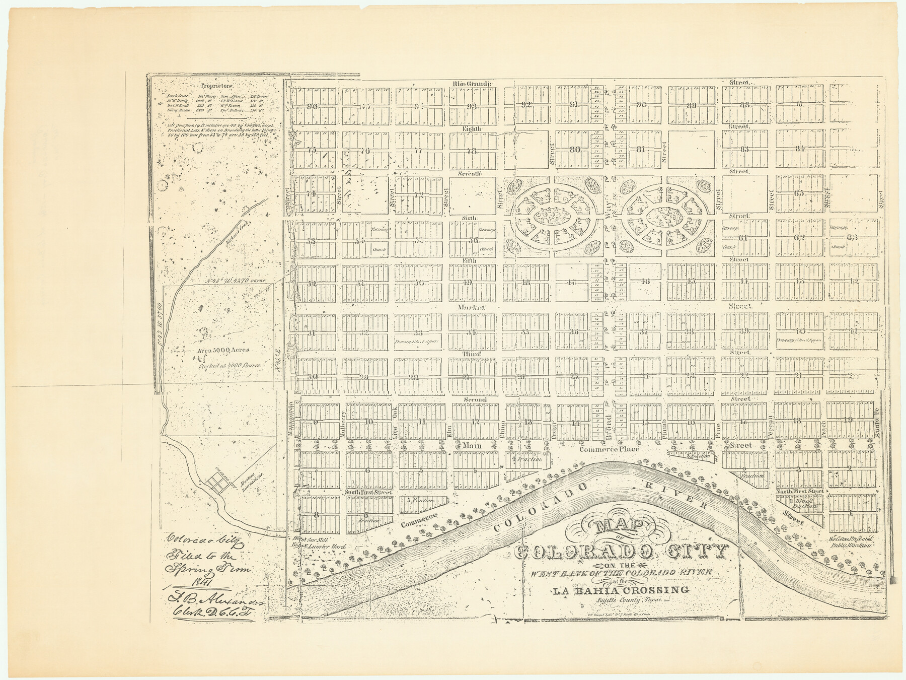
Map of Colorado City on the west bank of the Colorado River at the La Bahia crossing
-
Map/Doc
94750
-
Collection
Non-GLO Digital Images
-
Object Dates
1841 (Creation Date)
-
Counties
Fayette
-
Subjects
City
-
Height x Width
24.4 x 32.5 inches
62.0 x 82.6 cm
-
Medium
digital image
-
Comments
Image provided by JT Koenig in June 2018.
Part of: Non-GLO Digital Images
The Official Map of the City of El Paso, State of Texas

Print $20.00
The Official Map of the City of El Paso, State of Texas
1889
Size 42.4 x 54.4 inches
Map/Doc 89617

City Map of Weatherford, Texas

Print $20.00
City Map of Weatherford, Texas
Size 46.0 x 46.8 inches
Map/Doc 93697
Bird's Eye View of La Grange, Fayette County, Texas

Print $20.00
Bird's Eye View of La Grange, Fayette County, Texas
1880
Size 24.1 x 31.2 inches
Map/Doc 89096
Bird's Eye View of the City of Brenham, Washington County, Texas

Print $20.00
Bird's Eye View of the City of Brenham, Washington County, Texas
1881
Size 19.4 x 26.7 inches
Map/Doc 89076
Plano del Presidio de Bahia dela Espiritu Santo dependite dela Governacion de los Tejas situado en 29 grad. Y 39 min. de latitud boreal y 277° y 54' dela long. contados desde el Merid. De Tenerife

Plano del Presidio de Bahia dela Espiritu Santo dependite dela Governacion de los Tejas situado en 29 grad. Y 39 min. de latitud boreal y 277° y 54' dela long. contados desde el Merid. De Tenerife
1768
Size 16.7 x 21.0 inches
Map/Doc 96565
Plano del Presidio de Nra. Senora del Pilar de los Adaes, Capital de la Provincia de los Tejas situado en 32 grados y 15 minutos de Latitud Boreal, y en 285° y 52' de Longitud respecto del Meridiano de Tenerife

Plano del Presidio de Nra. Senora del Pilar de los Adaes, Capital de la Provincia de los Tejas situado en 32 grados y 15 minutos de Latitud Boreal, y en 285° y 52' de Longitud respecto del Meridiano de Tenerife
Size 16.9 x 21.4 inches
Map/Doc 96563
Carte de la Louisiane et Pays Voisins Pour servir a l'Histoire Generale des Voyages

Print $20.00
Carte de la Louisiane et Pays Voisins Pour servir a l'Histoire Generale des Voyages
1757
Size 9.6 x 14.9 inches
Map/Doc 94572
Fort Worth, Tex. "The Queen of the Prairies," County Seat of Tarrant County

Print $20.00
Fort Worth, Tex. "The Queen of the Prairies," County Seat of Tarrant County
1886
Size 26.0 x 33.3 inches
Map/Doc 89082
Engineer map showing engineer information at 23 O'Clock 23 Oct. 1918 drawn under direction of Col. W.A. Mitchell - Verso

Print $20.00
Engineer map showing engineer information at 23 O'Clock 23 Oct. 1918 drawn under direction of Col. W.A. Mitchell - Verso
1918
Size 19.7 x 12.6 inches
Map/Doc 94128

Bird's Eye View of New Braunfels, Comal County, Texas

Print $20.00
Bird's Eye View of New Braunfels, Comal County, Texas
1881
Size 17.0 x 24.1 inches
Map/Doc 89200
You may also like
[Castro, Lamb, Hockley, Swisher, Hale, and Lubbock Counties]
![91026, [Castro, Lamb, Hockley, Swisher, Hale, and Lubbock Counties], Twichell Survey Records](https://historictexasmaps.com/wmedia_w700/maps/91026-1.tif.jpg)
Print $20.00
- Digital $50.00
[Castro, Lamb, Hockley, Swisher, Hale, and Lubbock Counties]
Size 28.7 x 37.6 inches
Map/Doc 91026
Tom Green County

Print $40.00
- Digital $50.00
Tom Green County
1942
Size 55.3 x 46.8 inches
Map/Doc 73304
Houston County Sketch File 5

Print $4.00
- Digital $50.00
Houston County Sketch File 5
1860
Size 8.5 x 12.7 inches
Map/Doc 26757
Hansford County Rolled Sketch 1

Print $20.00
- Digital $50.00
Hansford County Rolled Sketch 1
1979
Size 22.3 x 17.6 inches
Map/Doc 6064
Tarrant County Working Sketch 18

Print $20.00
- Digital $50.00
Tarrant County Working Sketch 18
1996
Size 20.4 x 18.5 inches
Map/Doc 62435
Map of Callahan County

Print $20.00
- Digital $50.00
Map of Callahan County
1878
Size 23.0 x 18.8 inches
Map/Doc 3361

Cass County Working Sketch 47b

Print $20.00
- Digital $50.00
Cass County Working Sketch 47b
1992
Size 32.3 x 36.4 inches
Map/Doc 76063
Zavala County Boundary File 4

Print $42.00
- Digital $50.00
Zavala County Boundary File 4
Size 9.2 x 7.9 inches
Map/Doc 60271
Travis County State Real Property Sketch 14

Print $40.00
- Digital $50.00
Travis County State Real Property Sketch 14
1995
Size 18.1 x 23.9 inches
Map/Doc 61672
Crockett County Working Sketch 1

Print $20.00
- Digital $50.00
Crockett County Working Sketch 1
Size 20.7 x 16.7 inches
Map/Doc 68334
Treaty to Resolve Pending Boundary Differences and Maintain the Rio Grande and Colorado River as the International Boundary Between the United States of American and Mexico

Print $20.00
- Digital $50.00
Treaty to Resolve Pending Boundary Differences and Maintain the Rio Grande and Colorado River as the International Boundary Between the United States of American and Mexico
1970
Size 11.0 x 35.3 inches
Map/Doc 83103