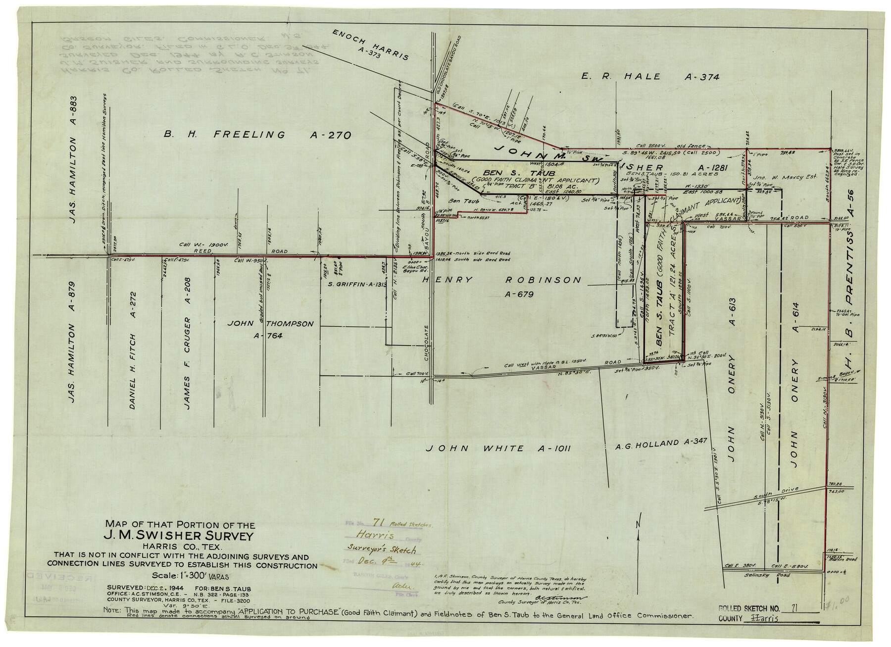
Harris County Rolled Sketch 71
Map of that portion of the J.M. Swisher survey, Harris Co., Tex. that is not in conflict with the adjoining surveys and connection lines surveyed to establish this construction
-
Map/Doc
6111
-
Collection
General Map Collection
-
Object Dates
12/2/1944 (Creation Date)
12/9/1944 (File Date)
-
People and Organizations
A.C. Stimson (Surveyor/Engineer)
-
Counties
Harris
-
Subjects
Surveying Rolled Sketch
-
Height x Width
19.3 x 26.7 inches
49.0 x 67.8 cm
-
Medium
linen, manuscript
-
Scale
1" = 300 varas
Part of: General Map Collection
Presidio County Rolled Sketch 82

Print $20.00
- Digital $50.00
Presidio County Rolled Sketch 82
1943
Size 35.5 x 26.1 inches
Map/Doc 7369
Montague County Boundary File 2b

Print $10.00
- Digital $50.00
Montague County Boundary File 2b
Size 9.0 x 11.1 inches
Map/Doc 57414
Brewster County Sketch File NS-4g

Print $4.00
- Digital $50.00
Brewster County Sketch File NS-4g
1930
Size 10.5 x 7.2 inches
Map/Doc 15981
Chart showing the relative positions of the lights in the Eighth Light House District extending from Cedar Keys, Florida to Rio Grande, Texas

Print $20.00
- Digital $50.00
Chart showing the relative positions of the lights in the Eighth Light House District extending from Cedar Keys, Florida to Rio Grande, Texas
1876
Size 24.7 x 18.2 inches
Map/Doc 72680
Flight Mission No. BRA-6M, Frame 145, Jefferson County

Print $20.00
- Digital $50.00
Flight Mission No. BRA-6M, Frame 145, Jefferson County
1953
Size 18.4 x 22.4 inches
Map/Doc 85446
Flight Mission No. CGI-4N, Frame 187, Cameron County

Print $20.00
- Digital $50.00
Flight Mission No. CGI-4N, Frame 187, Cameron County
1955
Size 18.8 x 22.4 inches
Map/Doc 84690
Culberson County Sketch File 1c

Print $4.00
- Digital $50.00
Culberson County Sketch File 1c
1859
Size 7.4 x 8.0 inches
Map/Doc 20111
Denton County Sketch File 9

Print $6.00
- Digital $50.00
Denton County Sketch File 9
1856
Size 8.6 x 13.3 inches
Map/Doc 20705
Comanche County Milam Land District

Print $20.00
- Digital $50.00
Comanche County Milam Land District
1876
Size 22.1 x 23.0 inches
Map/Doc 3433
Stonewall County Rolled Sketch 22

Print $20.00
- Digital $50.00
Stonewall County Rolled Sketch 22
1951
Size 33.3 x 30.7 inches
Map/Doc 76011
Stonewall County Rolled Sketch 28

Print $20.00
- Digital $50.00
Stonewall County Rolled Sketch 28
Size 42.8 x 46.5 inches
Map/Doc 9967
Flight Mission No. DAG-4C, Frame 150, Matagorda County

Print $20.00
- Digital $50.00
Flight Mission No. DAG-4C, Frame 150, Matagorda County
1943
Size 18.5 x 18.4 inches
Map/Doc 86441
You may also like
Flight Mission No. BQR-22K, Frame 36, Brazoria County

Print $20.00
- Digital $50.00
Flight Mission No. BQR-22K, Frame 36, Brazoria County
1953
Size 18.6 x 22.4 inches
Map/Doc 84120
Abandoned and Canceled Surveys - Volume 3 of 3, Counties L-Z

Abandoned and Canceled Surveys - Volume 3 of 3, Counties L-Z
Map/Doc 83250
Hemphill County Working Sketch 7

Print $20.00
- Digital $50.00
Hemphill County Working Sketch 7
1964
Size 41.1 x 46.8 inches
Map/Doc 66102
Harrison County Sketch File 23

Print $125.00
- Digital $50.00
Harrison County Sketch File 23
Size 10.6 x 12.2 inches
Map/Doc 26061
Aransas County NRC Article 33.136 Sketch 11

Print $54.00
- Digital $50.00
Aransas County NRC Article 33.136 Sketch 11
2012
Size 36.0 x 48.0 inches
Map/Doc 94502
Bravo Deed, Instrument 24, Tract A and Tract B

Print $3.00
- Digital $50.00
Bravo Deed, Instrument 24, Tract A and Tract B
Size 10.6 x 13.2 inches
Map/Doc 91478
Wichita Falls, Wichita County, Texas

Print $20.00
- Digital $50.00
Wichita Falls, Wichita County, Texas
Size 32.0 x 22.6 inches
Map/Doc 96791
Kent County Working Sketch 3b

Print $20.00
- Digital $50.00
Kent County Working Sketch 3b
1948
Size 24.9 x 23.3 inches
Map/Doc 70010
San Patricio County Sketch File 50

Print $8.00
- Digital $50.00
San Patricio County Sketch File 50
1873
Size 14.4 x 8.8 inches
Map/Doc 36371
Brewster County Rolled Sketch 49

Print $20.00
- Digital $50.00
Brewster County Rolled Sketch 49
1930
Size 35.1 x 47.4 inches
Map/Doc 8478
Wichita County Boundary File 2b

Print $4.00
- Digital $50.00
Wichita County Boundary File 2b
Size 8.9 x 8.8 inches
Map/Doc 59911
Henderson County Sketch File 5

Print $4.00
- Digital $50.00
Henderson County Sketch File 5
1853
Size 12.9 x 8.2 inches
Map/Doc 26325