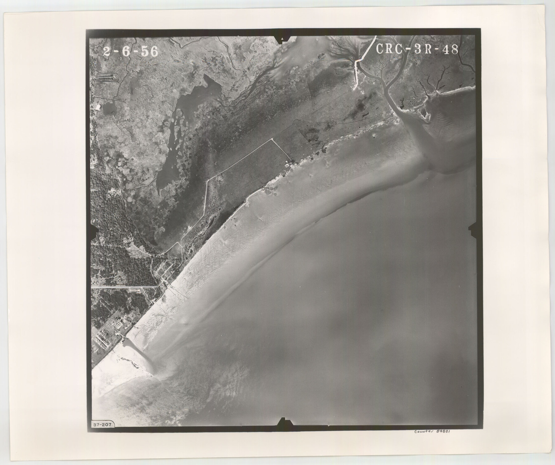
Flight Mission No. CRC-3R, Frame 48, Chambers County
CRC-3R-48
-
Map/Doc
84821
-
Collection
General Map Collection
-
Object Dates
1956/2/6 (Creation Date)
-
People and Organizations
U. S. Department of Agriculture (Publisher)
-
Counties
Chambers
-
Subjects
Aerial Photograph
-
Height x Width
18.7 x 22.4 inches
47.5 x 56.9 cm
-
Comments
Flown by Jack Ammann Photogrammetric Engineers, Inc. of San Antonio, Texas.
Part of: General Map Collection
Territory of New Mexico

Print $20.00
- Digital $50.00
Territory of New Mexico
1903
Size 23.8 x 19.6 inches
Map/Doc 82011
Live Oak County Rolled Sketch 2

Print $20.00
- Digital $50.00
Live Oak County Rolled Sketch 2
1944
Size 34.1 x 26.6 inches
Map/Doc 6632
Hockley County Boundary File 1

Print $8.00
- Digital $50.00
Hockley County Boundary File 1
Size 13.5 x 8.5 inches
Map/Doc 54798
Right of Way and Track Map of The Wichita Falls & Southern Railroad Company

Print $40.00
- Digital $50.00
Right of Way and Track Map of The Wichita Falls & Southern Railroad Company
1942
Size 24.4 x 56.4 inches
Map/Doc 64515
Anderson County Boundary File 7

Print $10.00
- Digital $50.00
Anderson County Boundary File 7
Size 14.4 x 8.9 inches
Map/Doc 49751
Louisiana and Texas Intracoastal Waterway - Entrance near Port O'Connor, Texas, Survey of September, 1940

Print $20.00
- Digital $50.00
Louisiana and Texas Intracoastal Waterway - Entrance near Port O'Connor, Texas, Survey of September, 1940
1940
Size 31.2 x 41.5 inches
Map/Doc 61822
Denton County Rolled Sketch 8

Print $20.00
- Digital $50.00
Denton County Rolled Sketch 8
2007
Size 24.5 x 18.2 inches
Map/Doc 88762
Fractional Township No. 10 South Range No. 2 East of the Indian Meridian, Indian Territory

Print $20.00
- Digital $50.00
Fractional Township No. 10 South Range No. 2 East of the Indian Meridian, Indian Territory
1898
Size 19.2 x 24.4 inches
Map/Doc 75202
Hamilton County Working Sketch 7

Print $20.00
- Digital $50.00
Hamilton County Working Sketch 7
1942
Size 15.2 x 20.2 inches
Map/Doc 63345
Midland County Boundary File 1

Print $40.00
- Digital $50.00
Midland County Boundary File 1
Size 7.0 x 6.6 inches
Map/Doc 57140
San Jacinto County Working Sketch 41

Print $20.00
- Digital $50.00
San Jacinto County Working Sketch 41
1979
Size 44.6 x 35.2 inches
Map/Doc 63754
La Salle County Rolled Sketch 5

Print $20.00
- Digital $50.00
La Salle County Rolled Sketch 5
1937
Size 17.8 x 27.4 inches
Map/Doc 6570
You may also like
Runnels County Sketch File E

Print $6.00
Runnels County Sketch File E
1895
Size 12.7 x 8.3 inches
Map/Doc 35481

Part of Tom Green County, Texas (No. 3)

Print $20.00
- Digital $50.00
Part of Tom Green County, Texas (No. 3)
1870
Size 22.9 x 17.7 inches
Map/Doc 5047
Where Did Columbus Discover America?

Where Did Columbus Discover America?
1986
Size 14.7 x 20.6 inches
Map/Doc 96837
Reeves County Working Sketch 6

Print $20.00
- Digital $50.00
Reeves County Working Sketch 6
1943
Size 14.1 x 18.4 inches
Map/Doc 63449
[Pitchfork Ranch]
![4480, [Pitchfork Ranch], Maddox Collection](https://historictexasmaps.com/wmedia_w700/maps/4480.tif.jpg)
Print $20.00
- Digital $50.00
[Pitchfork Ranch]
1915
Size 20.8 x 17.2 inches
Map/Doc 4480
[Beaumont, Sour Lake and Western Ry. Right of Way and Alignment - Frisco]
![64123, [Beaumont, Sour Lake and Western Ry. Right of Way and Alignment - Frisco], General Map Collection](https://historictexasmaps.com/wmedia_w700/maps/64123.tif.jpg)
Print $20.00
- Digital $50.00
[Beaumont, Sour Lake and Western Ry. Right of Way and Alignment - Frisco]
1910
Size 20.4 x 46.2 inches
Map/Doc 64123

Railroad Track Map, H&TCRRCo., Falls County, Texas

Print $4.00
- Digital $50.00
Railroad Track Map, H&TCRRCo., Falls County, Texas
1918
Size 11.8 x 18.6 inches
Map/Doc 62836
Crockett County Rolled Sketch 41

Print $20.00
- Digital $50.00
Crockett County Rolled Sketch 41
Size 24.7 x 19.6 inches
Map/Doc 5591
Karnes County Working Sketch 13
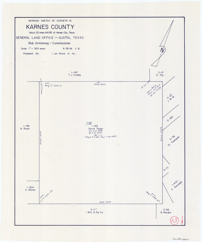
Print $20.00
- Digital $50.00
Karnes County Working Sketch 13
1981
Size 20.2 x 16.8 inches
Map/Doc 66661
Railroad Track Map, H&TCRRCo., Falls County, Texas

Print $4.00
- Digital $50.00
Railroad Track Map, H&TCRRCo., Falls County, Texas
1918
Size 11.6 x 18.6 inches
Map/Doc 62848