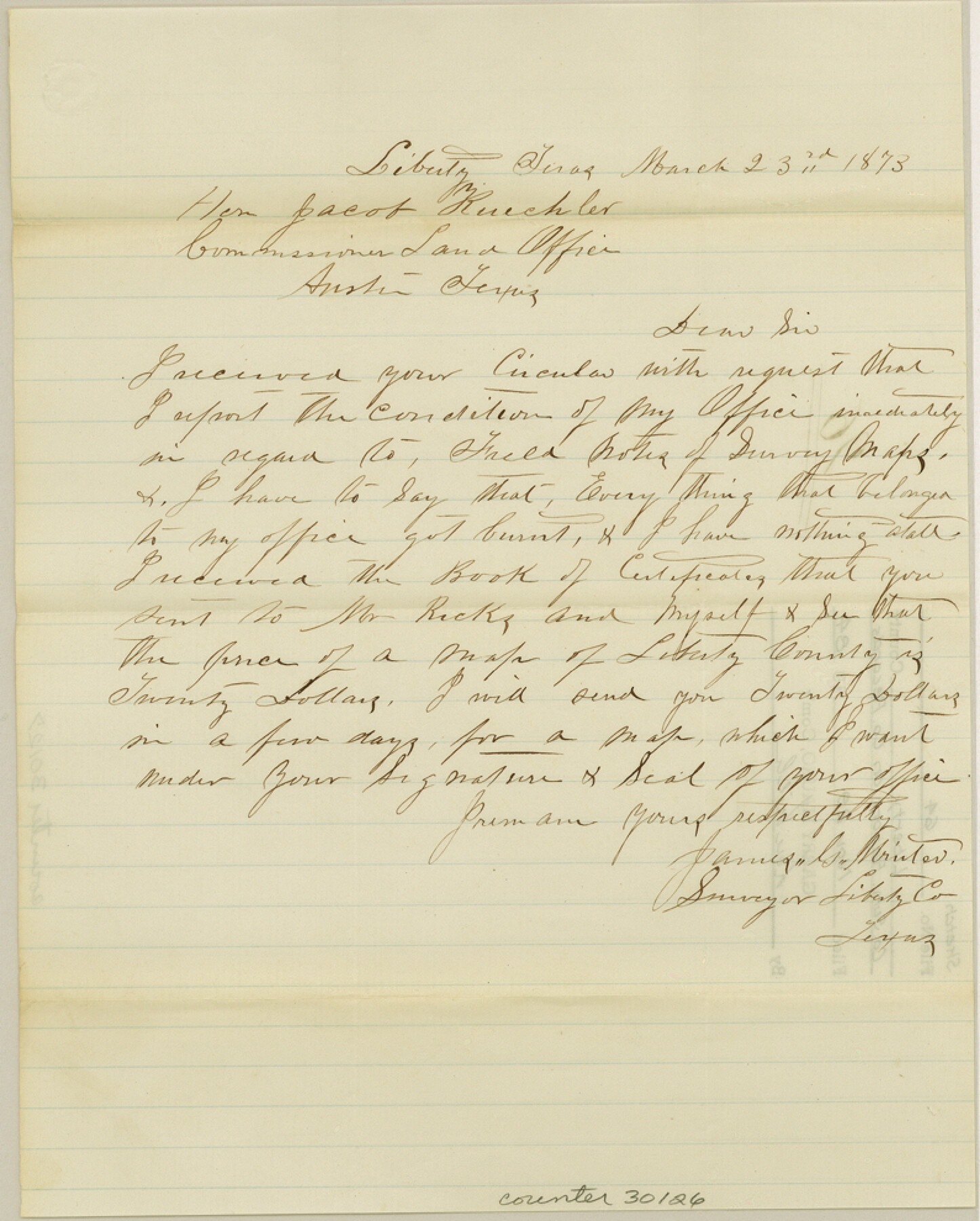
Liberty County Sketch File 64
[County Surveyor's report on county records]
-
Map/Doc
30126
-
Collection
General Map Collection
-
Object Dates
3/23/1873 (Creation Date)
11/29/1984 (File Date)
-
People and Organizations
James G. Minter (Surveyor/Engineer)
-
Counties
Liberty
-
Subjects
Surveying Sketch File
-
Height x Width
9.9 x 7.9 inches
25.2 x 20.1 cm
-
Medium
paper, manuscript
Part of: General Map Collection
Presidio County Working Sketch 21

Print $20.00
- Digital $50.00
Presidio County Working Sketch 21
1945
Size 25.4 x 35.9 inches
Map/Doc 71697
Culberson County Working Sketch 22

Print $20.00
- Digital $50.00
Culberson County Working Sketch 22
1938
Size 23.0 x 18.7 inches
Map/Doc 68474
Newton County Sketch File 19

Print $20.00
- Digital $50.00
Newton County Sketch File 19
Size 22.8 x 9.4 inches
Map/Doc 42158
Padre Island National Seashore

Print $4.00
- Digital $50.00
Padre Island National Seashore
Size 16.0 x 21.9 inches
Map/Doc 60526
Marion County Working Sketch 36

Print $20.00
- Digital $50.00
Marion County Working Sketch 36
1987
Size 23.5 x 28.9 inches
Map/Doc 70812
Flight Mission No. DQN-4K, Frame 7, Calhoun County

Print $20.00
- Digital $50.00
Flight Mission No. DQN-4K, Frame 7, Calhoun County
1953
Size 18.5 x 22.2 inches
Map/Doc 84372
Hemphill County Rolled Sketch 10

Print $20.00
- Digital $50.00
Hemphill County Rolled Sketch 10
Size 19.4 x 27.6 inches
Map/Doc 6192
Presidio County Sketch File 58a

Print $14.00
- Digital $50.00
Presidio County Sketch File 58a
1980
Size 11.2 x 8.8 inches
Map/Doc 34628
Briscoe County Rolled Sketch 18

Print $20.00
- Digital $50.00
Briscoe County Rolled Sketch 18
1946
Size 36.7 x 27.3 inches
Map/Doc 5332
Field Notes of Mercer's Colony, Robertson, Nac[a]gdoches, Fannin, & Lamar Counties.
![1953, Field Notes of Mercer's Colony, Robertson, Nac[a]gdoches, Fannin, & Lamar Counties., General Map Collection](https://historictexasmaps.com/wmedia_w700/pdf_converted_jpg/qi_pdf_thumbnail_897.jpg)
Print $30.00
- Digital $50.00
Field Notes of Mercer's Colony, Robertson, Nac[a]gdoches, Fannin, & Lamar Counties.
1845
Size 9.5 x 14.8 inches
Map/Doc 1953

Jefferson County Rolled Sketch 48A

Print $20.00
- Digital $50.00
Jefferson County Rolled Sketch 48A
1964
Size 28.4 x 28.1 inches
Map/Doc 6404
You may also like
[Copy of a portion of] The Coast & Bays of Western Texas, St. Joseph's and Mustang Islands from Actual Survey, the Remainder from County Maps, Etc.
![72768, [Copy of a portion of] The Coast & Bays of Western Texas, St. Joseph's and Mustang Islands from Actual Survey, the Remainder from County Maps, Etc., General Map Collection](https://historictexasmaps.com/wmedia_w700/maps/72768.tif.jpg)
Print $20.00
- Digital $50.00
[Copy of a portion of] The Coast & Bays of Western Texas, St. Joseph's and Mustang Islands from Actual Survey, the Remainder from County Maps, Etc.
1857
Size 26.0 x 18.3 inches
Map/Doc 72768
Val Verde County Working Sketch 64

Print $20.00
- Digital $50.00
Val Verde County Working Sketch 64
1959
Size 19.0 x 43.0 inches
Map/Doc 72199
Starr County Working Sketch 25

Print $20.00
- Digital $50.00
Starr County Working Sketch 25
1988
Size 38.5 x 27.9 inches
Map/Doc 63941
Flight Mission No. DAH-17M, Frame 26, Orange County

Print $20.00
- Digital $50.00
Flight Mission No. DAH-17M, Frame 26, Orange County
1953
Size 18.3 x 22.3 inches
Map/Doc 86889
Trinity County Boundary File 102

Print $14.00
- Digital $50.00
Trinity County Boundary File 102
Size 9.2 x 4.6 inches
Map/Doc 59480
Kent County Sketch File 13

Print $6.00
- Digital $50.00
Kent County Sketch File 13
1921
Size 11.1 x 8.7 inches
Map/Doc 28839
Flight Mission No. BRE-1P, Frame 28, Nueces County

Print $20.00
- Digital $50.00
Flight Mission No. BRE-1P, Frame 28, Nueces County
1956
Size 16.6 x 16.1 inches
Map/Doc 86624
Pecos County Working Sketch 79

Print $20.00
- Digital $50.00
Pecos County Working Sketch 79
1960
Size 22.6 x 24.3 inches
Map/Doc 71551
Fisher County Sketch File 8

Print $16.00
- Digital $50.00
Fisher County Sketch File 8
1898
Size 14.7 x 9.1 inches
Map/Doc 22567
Terrell County Rolled Sketch 42

Print $20.00
- Digital $50.00
Terrell County Rolled Sketch 42
1948
Size 27.4 x 38.6 inches
Map/Doc 7945
Mills County Boundary File 1

Print $28.00
- Digital $50.00
Mills County Boundary File 1
Size 8.3 x 8.0 inches
Map/Doc 57259
Culberson County Working Sketch 62

Print $20.00
- Digital $50.00
Culberson County Working Sketch 62
1975
Size 32.2 x 24.6 inches
Map/Doc 68516