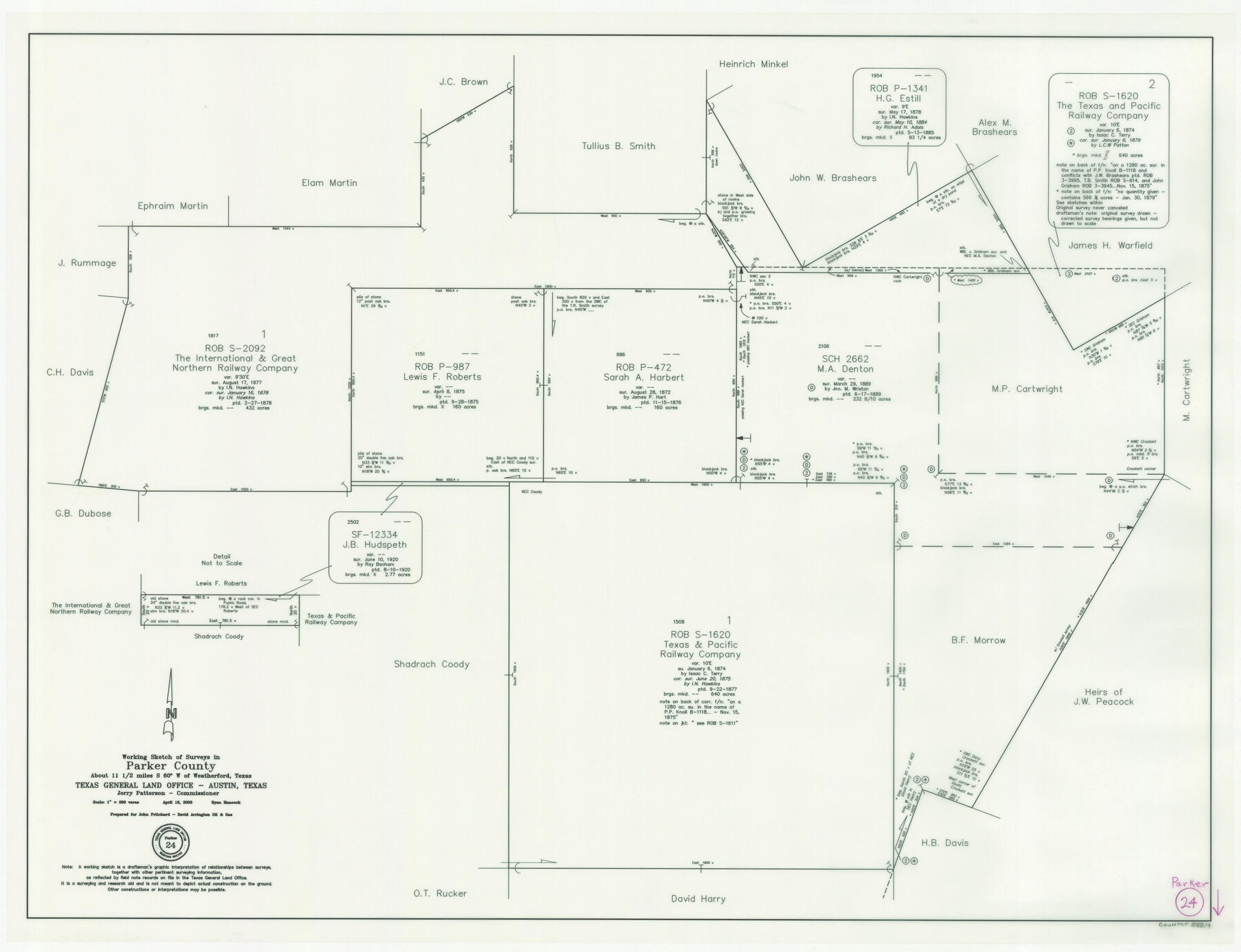
Parker County Working Sketch 24
-
Map/Doc
88814
-
Collection
General Map Collection
-
Object Dates
4/16/2008 (Creation Date)
-
People and Organizations
Jerry E. Patterson (GLO Commissioner)
Ryan Hancock (Draftsman)
-
Counties
Parker
-
Subjects
Surveying Working Sketch
-
Scale
1" = 200 varas
Part of: General Map Collection
Brewster County Rolled Sketch 114

Print $20.00
- Digital $50.00
Brewster County Rolled Sketch 114
1964
Size 11.5 x 17.6 inches
Map/Doc 5274
Lubbock County Sketch File 3

Print $4.00
- Digital $50.00
Lubbock County Sketch File 3
1901
Size 13.0 x 8.2 inches
Map/Doc 30420
Bosque County Working Sketch 11

Print $20.00
- Digital $50.00
Bosque County Working Sketch 11
1952
Size 10.8 x 30.4 inches
Map/Doc 67444
Outer Continental Shelf Leasing Maps (Louisiana Offshore Operations)

Print $20.00
- Digital $50.00
Outer Continental Shelf Leasing Maps (Louisiana Offshore Operations)
1959
Size 17.9 x 14.0 inches
Map/Doc 76097
Travis County Working Sketch 31

Print $20.00
- Digital $50.00
Travis County Working Sketch 31
1965
Size 31.2 x 35.6 inches
Map/Doc 69415

Glasscock County Rolled Sketch 5

Print $20.00
- Digital $50.00
Glasscock County Rolled Sketch 5
1944
Size 41.4 x 33.7 inches
Map/Doc 6016
Intracoastal Waterway in Texas - Corpus Christi to Point Isabel including Arroyo Colorado to Mo. Pac. R.R. Bridge Near Harlingen

Print $20.00
- Digital $50.00
Intracoastal Waterway in Texas - Corpus Christi to Point Isabel including Arroyo Colorado to Mo. Pac. R.R. Bridge Near Harlingen
1934
Size 21.9 x 32.5 inches
Map/Doc 61881
Flight Mission No. BRA-16M, Frame 167, Jefferson County

Print $20.00
- Digital $50.00
Flight Mission No. BRA-16M, Frame 167, Jefferson County
1953
Size 18.5 x 22.3 inches
Map/Doc 85765
Midland County Sketch File 4

Print $20.00
- Digital $50.00
Midland County Sketch File 4
1886
Size 16.3 x 18.9 inches
Map/Doc 12082
Lamb County Boundary File 4

Print $16.00
- Digital $50.00
Lamb County Boundary File 4
Size 11.3 x 8.7 inches
Map/Doc 56084
Trinity River, Cooks Ferry Sheet

Print $40.00
- Digital $50.00
Trinity River, Cooks Ferry Sheet
1926
Size 36.5 x 56.2 inches
Map/Doc 65215
You may also like
Nacogdoches County Sketch File 19

Print $12.00
- Digital $50.00
Nacogdoches County Sketch File 19
1846
Size 17.0 x 11.0 inches
Map/Doc 32270
Edwards County Working Sketch 82

Print $20.00
- Digital $50.00
Edwards County Working Sketch 82
1964
Size 31.0 x 35.1 inches
Map/Doc 68958
Presidio County Sketch File B

Print $20.00
- Digital $50.00
Presidio County Sketch File B
Size 25.2 x 21.3 inches
Map/Doc 11701
Wharton County Rolled Sketch 11

Print $20.00
- Digital $50.00
Wharton County Rolled Sketch 11
Size 27.7 x 37.1 inches
Map/Doc 8236
Flight Mission No. BRA-16M, Frame 70, Jefferson County

Print $20.00
- Digital $50.00
Flight Mission No. BRA-16M, Frame 70, Jefferson County
1953
Size 18.6 x 22.3 inches
Map/Doc 85687
Shelby County Sketch File 24

Print $36.00
- Digital $50.00
Shelby County Sketch File 24
1850
Size 13.0 x 8.1 inches
Map/Doc 36647
Plan of the City of Galveston, Texas

Print $20.00
- Digital $50.00
Plan of the City of Galveston, Texas
1845
Size 18.4 x 27.8 inches
Map/Doc 62970
Flight Mission No. DAG-21K, Frame 107, Matagorda County

Print $20.00
- Digital $50.00
Flight Mission No. DAG-21K, Frame 107, Matagorda County
1952
Size 18.6 x 22.4 inches
Map/Doc 86435
Frio County Boundary File 31

Print $19.00
- Digital $50.00
Frio County Boundary File 31
Size 9.3 x 4.4 inches
Map/Doc 53609
Starr County Rolled Sketch 23

Print $20.00
- Digital $50.00
Starr County Rolled Sketch 23
1938
Size 36.8 x 24.9 inches
Map/Doc 7807
Presidio County Sketch File 116

Print $86.00
- Digital $50.00
Presidio County Sketch File 116
1993
Size 11.4 x 8.7 inches
Map/Doc 34842
Texas Highway Map Points of Interest, Recreational Facilities Guide, Special Events Calendar [Recto]
![94187, Texas Highway Map Points of Interest, Recreational Facilities Guide, Special Events Calendar [Recto], General Map Collection](https://historictexasmaps.com/wmedia_w700/maps/94187.tif.jpg)
Texas Highway Map Points of Interest, Recreational Facilities Guide, Special Events Calendar [Recto]
1963
Size 30.9 x 18.2 inches
Map/Doc 94187