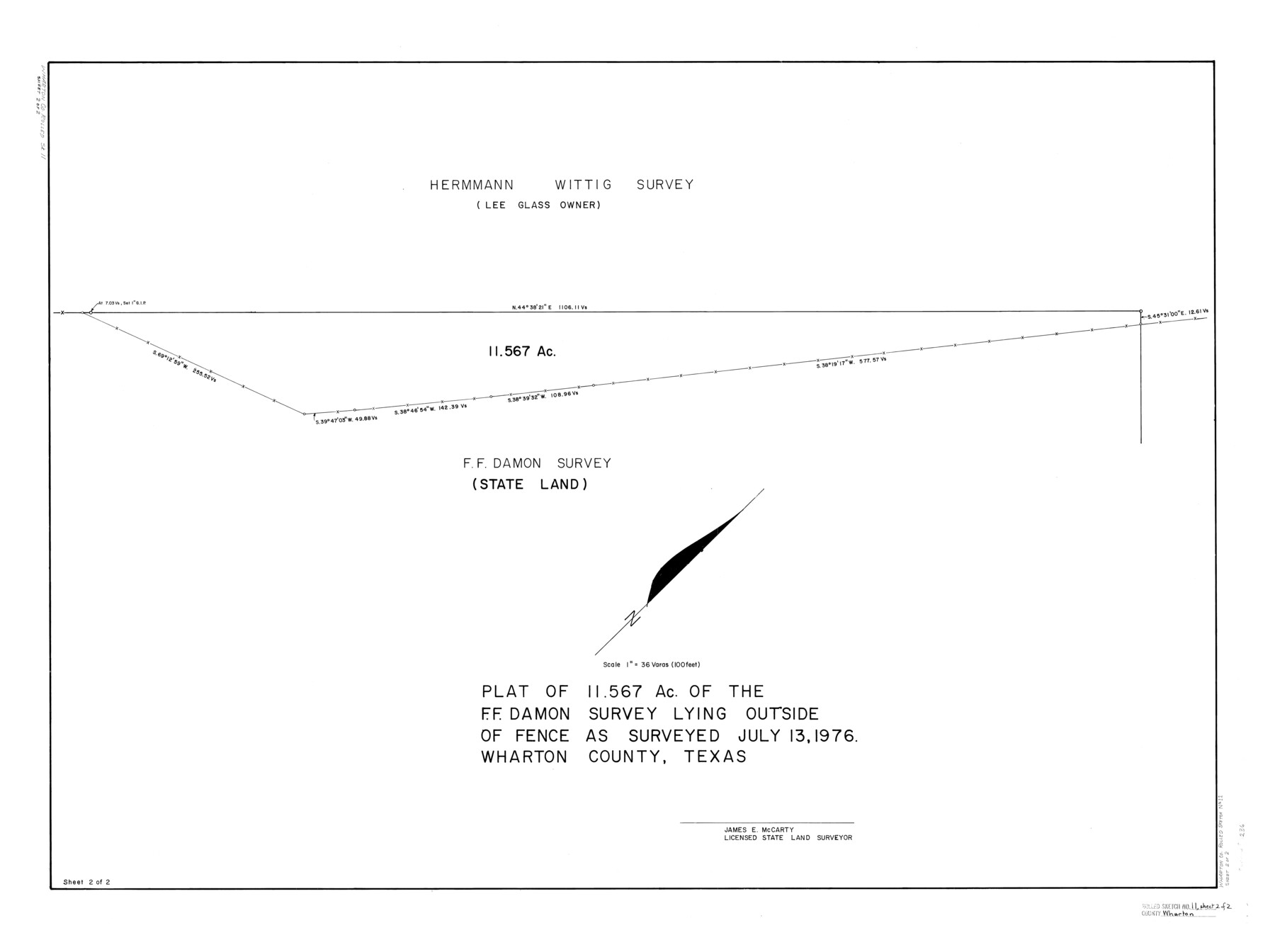
Wharton County Rolled Sketch 11
Plat of 11.567 ac. of the F.F. Damon survey lying outside of fence
-
Map/Doc
8236
-
Collection
General Map Collection
-
Object Dates
1976/7/13 (Survey Date)
1976/10/16 (File Date)
-
People and Organizations
James E. McCarty (Surveyor/Engineer)
-
Counties
Wharton
-
Subjects
Surveying Rolled Sketch
-
Height x Width
27.7 x 37.1 inches
70.4 x 94.2 cm
-
Medium
mylar, print
-
Scale
1" = 36 varas
Related maps
Wharton County Rolled Sketch 10

Print $20.00
- Digital $50.00
Wharton County Rolled Sketch 10
Size 21.9 x 32.8 inches
Map/Doc 8234
Wharton County Rolled Sketch 11

Print $20.00
- Digital $50.00
Wharton County Rolled Sketch 11
Size 27.3 x 37.2 inches
Map/Doc 8235
Part of: General Map Collection
Hydrographic Survey H-6396 of Outer Coast of Padre Island; Gulf of Mexico

Print $40.00
- Digital $50.00
Hydrographic Survey H-6396 of Outer Coast of Padre Island; Gulf of Mexico
1938
Size 55.4 x 34.0 inches
Map/Doc 2698
Post Route Map of the State of Texas showing post offices with the intermediate distances on mail routes in operation on the 1st of March, 1907

Print $40.00
- Digital $50.00
Post Route Map of the State of Texas showing post offices with the intermediate distances on mail routes in operation on the 1st of March, 1907
1907
Size 50.1 x 68.0 inches
Map/Doc 2090
Calhoun County Rolled Sketch 26

Print $20.00
- Digital $50.00
Calhoun County Rolled Sketch 26
1941
Size 10.9 x 39.9 inches
Map/Doc 5374
Frio County Sketch File A

Print $40.00
- Digital $50.00
Frio County Sketch File A
1878
Size 16.4 x 13.4 inches
Map/Doc 23099
La Salle County Sketch File 29

Print $4.00
- Digital $50.00
La Salle County Sketch File 29
1889
Size 9.0 x 13.6 inches
Map/Doc 29561
Part of Laguna Madre in Cameron County, showing Subdivision for Mineral Development

Print $20.00
- Digital $50.00
Part of Laguna Madre in Cameron County, showing Subdivision for Mineral Development
1953
Size 33.0 x 21.9 inches
Map/Doc 1927
Flight Mission No. CRC-2R, Frame 193, Chambers County

Print $20.00
- Digital $50.00
Flight Mission No. CRC-2R, Frame 193, Chambers County
1956
Size 18.9 x 22.5 inches
Map/Doc 84771
Zavala County Working Sketch 10

Print $20.00
- Digital $50.00
Zavala County Working Sketch 10
1954
Size 30.4 x 38.8 inches
Map/Doc 62085
Nueces County Rolled Sketch 110A

Print $20.00
- Digital $50.00
Nueces County Rolled Sketch 110A
1990
Size 24.3 x 37.5 inches
Map/Doc 7118
Val Verde County Sketch File A2

Print $10.00
- Digital $50.00
Val Verde County Sketch File A2
1916
Size 14.5 x 9.1 inches
Map/Doc 39041
[Galveston, Harrisburg & San Antonio Railway]
![64402, [Galveston, Harrisburg & San Antonio Railway], General Map Collection](https://historictexasmaps.com/wmedia_w700/maps/64402.tif.jpg)
Print $20.00
- Digital $50.00
[Galveston, Harrisburg & San Antonio Railway]
1892
Size 13.5 x 33.7 inches
Map/Doc 64402
East Part of Brewster Co.

Print $40.00
- Digital $50.00
East Part of Brewster Co.
1952
Size 48.5 x 30.7 inches
Map/Doc 77219
You may also like
Flight Mission No. DAH-9M, Frame 197, Orange County

Print $20.00
- Digital $50.00
Flight Mission No. DAH-9M, Frame 197, Orange County
1953
Size 18.5 x 22.4 inches
Map/Doc 86865

Oldham County Rolled Sketch 8

Print $20.00
- Digital $50.00
Oldham County Rolled Sketch 8
1931
Size 39.2 x 29.0 inches
Map/Doc 7174
Map of Encinal County

Print $20.00
- Digital $50.00
Map of Encinal County
1872
Size 30.5 x 20.3 inches
Map/Doc 3513
Flight Mission No. BQY-4M, Frame 40, Harris County

Print $20.00
- Digital $50.00
Flight Mission No. BQY-4M, Frame 40, Harris County
1953
Size 18.6 x 22.3 inches
Map/Doc 85255
Map of Polk County

Print $20.00
- Digital $50.00
Map of Polk County
1881
Size 25.7 x 21.1 inches
Map/Doc 3962
Gray County Working Sketch 5

Print $20.00
- Digital $50.00
Gray County Working Sketch 5
1959
Size 28.6 x 27.5 inches
Map/Doc 63236

Jackson County Working Sketch 4

Print $20.00
- Digital $50.00
Jackson County Working Sketch 4
1941
Size 34.1 x 28.5 inches
Map/Doc 66452
DeWitt County Boundary File 2

Print $30.00
- Digital $50.00
DeWitt County Boundary File 2
Size 10.6 x 8.0 inches
Map/Doc 52498
Pecos County Working Sketch 24

Print $20.00
- Digital $50.00
Pecos County Working Sketch 24
1928
Size 26.9 x 33.0 inches
Map/Doc 71495
Cram's Superior Map of Illinois

Print $40.00
- Digital $50.00
Cram's Superior Map of Illinois
1903
Size 50.2 x 40.5 inches
Map/Doc 97110