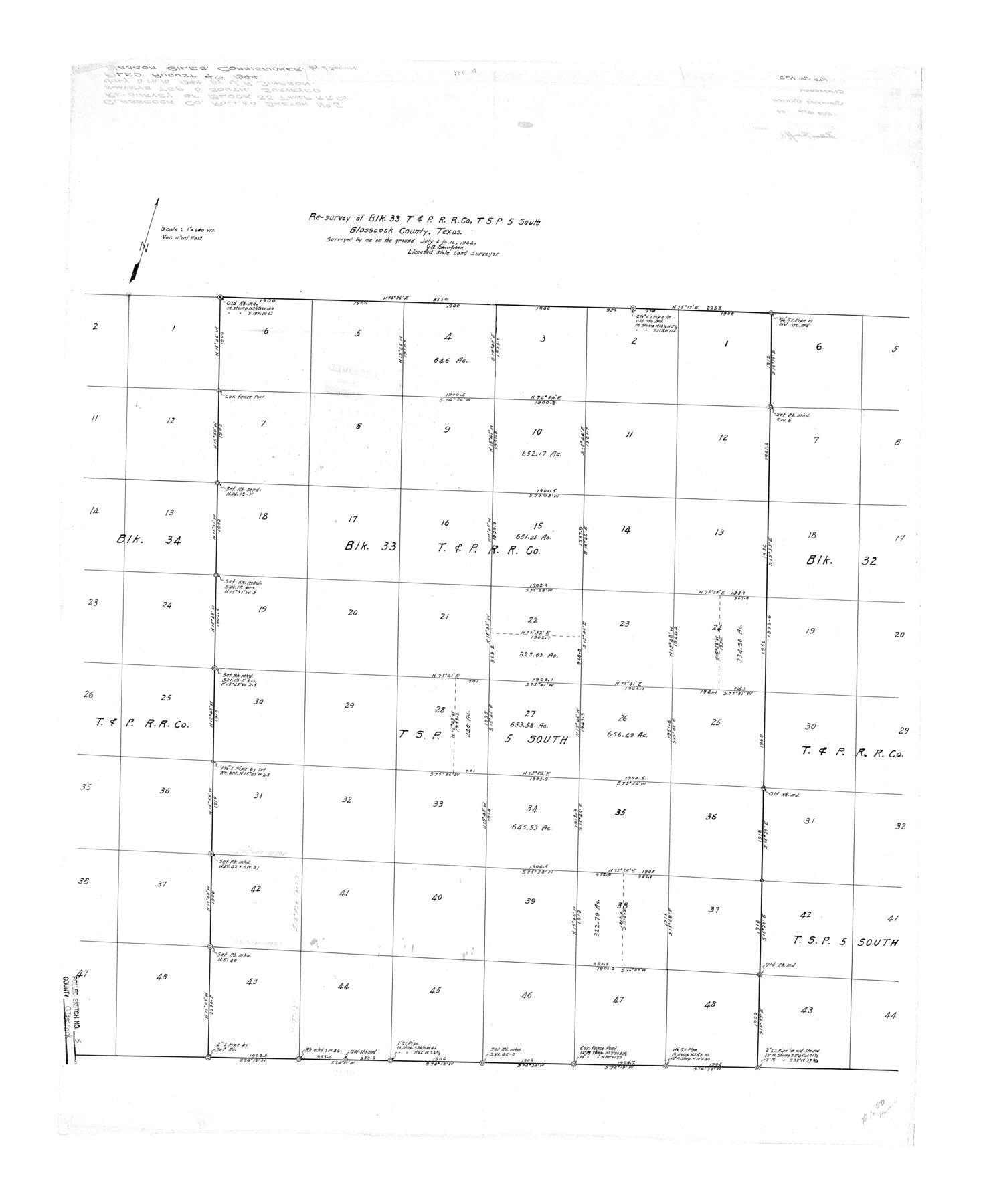
Glasscock County Rolled Sketch 5
Re-survey of Blk. 33, T. & P. R.R. Co., Tsp 5 South
-
Map/Doc
6016
-
Collection
General Map Collection
-
Object Dates
1944/7/16 (Creation Date)
1944/8/4 (File Date)
-
People and Organizations
J.A. Simpson (Surveyor/Engineer)
-
Counties
Glasscock
-
Subjects
Surveying Rolled Sketch
-
Height x Width
41.4 x 33.7 inches
105.2 x 85.6 cm
-
Scale
1" = 600 varas
Part of: General Map Collection
Culberson County Working Sketch 72

Print $40.00
- Digital $50.00
Culberson County Working Sketch 72
1975
Size 50.1 x 34.2 inches
Map/Doc 68526
Menard County Rolled Sketch 2A

Print $20.00
- Digital $50.00
Menard County Rolled Sketch 2A
1905
Size 23.3 x 18.5 inches
Map/Doc 6753
Haskell County Sketch File 6

Print $22.00
- Digital $50.00
Haskell County Sketch File 6
1858
Size 7.7 x 12.2 inches
Map/Doc 26126
Flight Mission No. DIX-5P, Frame 105, Aransas County

Print $20.00
- Digital $50.00
Flight Mission No. DIX-5P, Frame 105, Aransas County
1956
Size 17.7 x 17.8 inches
Map/Doc 83783
Donley County Sketch File B5

Print $20.00
- Digital $50.00
Donley County Sketch File B5
1918
Size 22.5 x 18.4 inches
Map/Doc 11375
Lipscomb County Working Sketch 6

Print $20.00
- Digital $50.00
Lipscomb County Working Sketch 6
1980
Size 35.7 x 20.8 inches
Map/Doc 70582
Sherman County Boundary File 2

Print $34.00
- Digital $50.00
Sherman County Boundary File 2
Size 13.0 x 9.0 inches
Map/Doc 58761
Lampasas County Working Sketch 16

Print $20.00
- Digital $50.00
Lampasas County Working Sketch 16
1977
Size 27.6 x 19.6 inches
Map/Doc 70293
Blanco County Boundary File 5

Print $100.00
- Digital $50.00
Blanco County Boundary File 5
Size 17.1 x 14.1 inches
Map/Doc 50555
Moore County Working Sketch 3

Print $20.00
- Digital $50.00
Moore County Working Sketch 3
1910
Size 12.2 x 17.4 inches
Map/Doc 71185
Concho County Sketch File 40

Print $26.00
- Digital $50.00
Concho County Sketch File 40
1949
Size 11.3 x 8.7 inches
Map/Doc 19194
Val Verde County Working Sketch 59

Print $20.00
- Digital $50.00
Val Verde County Working Sketch 59
1958
Size 38.6 x 35.0 inches
Map/Doc 72194
You may also like
The Republic County of Jackson. January 29, 1842

Print $20.00
The Republic County of Jackson. January 29, 1842
2020
Size 15.6 x 21.8 inches
Map/Doc 96189
Flight Mission No. DAG-17K, Frame 133, Matagorda County

Print $20.00
- Digital $50.00
Flight Mission No. DAG-17K, Frame 133, Matagorda County
1952
Size 18.6 x 22.3 inches
Map/Doc 86350
Wise County Working Sketch Graphic Index

Print $20.00
- Digital $50.00
Wise County Working Sketch Graphic Index
1942
Size 44.9 x 37.9 inches
Map/Doc 76745
Flight Mission No. BRA-16M, Frame 102, Jefferson County

Print $20.00
- Digital $50.00
Flight Mission No. BRA-16M, Frame 102, Jefferson County
1953
Size 18.6 x 22.3 inches
Map/Doc 85714
Trinity County Rolled Sketch 6

Print $20.00
- Digital $50.00
Trinity County Rolled Sketch 6
1999
Size 25.0 x 19.3 inches
Map/Doc 8053
Brewster County Rolled Sketch 101

Print $40.00
- Digital $50.00
Brewster County Rolled Sketch 101
1927
Size 74.2 x 42.3 inches
Map/Doc 9192
Fort Bend County Working Sketch 25

Print $40.00
- Digital $50.00
Fort Bend County Working Sketch 25
1981
Size 43.7 x 65.9 inches
Map/Doc 69231

Crockett County Rolled Sketch 88H

Print $40.00
- Digital $50.00
Crockett County Rolled Sketch 88H
1973
Size 42.6 x 57.3 inches
Map/Doc 8733
Culberson County Sketch File 32

Print $22.00
- Digital $50.00
Culberson County Sketch File 32
1952
Size 11.2 x 8.7 inches
Map/Doc 20285
Pecos County Working Sketch 128

Print $20.00
- Digital $50.00
Pecos County Working Sketch 128
1975
Size 20.4 x 21.5 inches
Map/Doc 71602
Runnels County Working Sketch 7

Print $20.00
- Digital $50.00
Runnels County Working Sketch 7
1929
Size 29.5 x 14.9 inches
Map/Doc 63603