Shelby County Sketch File 24
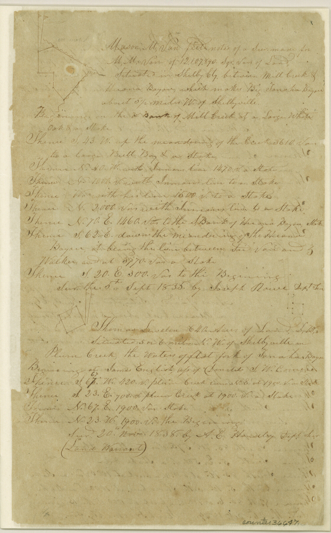
[Copies of miscellaneous field notes from Shelby County delivered from County Surveyor to Robert Creuzbaur]
-
Map/Doc
36647
-
Collection
General Map Collection
-
Object Dates
1/22/1850 (Creation Date)
-
People and Organizations
Richard Hooper (Surveyor/Engineer)
-
Counties
Shelby
-
Subjects
Surveying Sketch File
-
Height x Width
13.0 x 8.1 inches
33.0 x 20.6 cm
-
Medium
paper, manuscript
-
Scale
1" = 2000 varas
-
Features
Flat Fork of Tanaha Bayou
Yarborough's Creek
Stiles Creek
Brushy Fork
Hooper Creek
Polvadores Creek
Carrs Crossing
Bayou Blue
Sabine River
Mill Creek
Attoyac River
Ionan Bayou
Tanaha Bayou
Plum Creek
Shelbyville
Big Tanaha Bayou
Huana Bayou
Part of: General Map Collection
Hamilton County Working Sketch 4

Print $20.00
- Digital $50.00
Hamilton County Working Sketch 4
1935
Size 32.6 x 36.9 inches
Map/Doc 63342
Map of Nacogdoches County

Print $20.00
- Digital $50.00
Map of Nacogdoches County
1881
Size 24.3 x 21.9 inches
Map/Doc 4606
Hamilton Dam, Reservoir Clearing

Print $4.00
- Digital $50.00
Hamilton Dam, Reservoir Clearing
1936
Size 10.5 x 28.9 inches
Map/Doc 2096
Irion County Boundary File 3

Print $38.00
- Digital $50.00
Irion County Boundary File 3
Size 8.8 x 4.2 inches
Map/Doc 55339
Montgomery County Sketch File 6

Print $4.00
- Digital $50.00
Montgomery County Sketch File 6
Size 4.6 x 5.7 inches
Map/Doc 31781
Map of Lampasas County

Print $20.00
- Digital $50.00
Map of Lampasas County
1856
Size 19.7 x 25.3 inches
Map/Doc 3792
Burnet County Sketch File 27

Print $4.00
- Digital $50.00
Burnet County Sketch File 27
1874
Size 12.7 x 8.1 inches
Map/Doc 16730
Robertson County Working Sketch 7

Print $20.00
- Digital $50.00
Robertson County Working Sketch 7
1983
Size 36.4 x 38.5 inches
Map/Doc 63580
Pecos County Sketch File 112

Print $16.00
- Digital $50.00
Pecos County Sketch File 112
1892
Size 11.2 x 8.6 inches
Map/Doc 34061
Brazoria County Sketch File 28

Print $6.00
- Digital $50.00
Brazoria County Sketch File 28
1889
Size 8.8 x 14.2 inches
Map/Doc 15030
[Cotton Belt, St. Louis Southwestern Railway of Texas, Alignment through Smith County]
![64376, [Cotton Belt, St. Louis Southwestern Railway of Texas, Alignment through Smith County], General Map Collection](https://historictexasmaps.com/wmedia_w700/maps/64376-1.tif.jpg)
Print $20.00
- Digital $50.00
[Cotton Belt, St. Louis Southwestern Railway of Texas, Alignment through Smith County]
1903
Size 22.0 x 29.3 inches
Map/Doc 64376
Travis County Appraisal District Plat Map 2_2313

Print $20.00
- Digital $50.00
Travis County Appraisal District Plat Map 2_2313
Size 21.4 x 26.3 inches
Map/Doc 94215
You may also like
Registro de las de los documentos y títulos espedidos en la primera empresa de colonización del empresario Estevan F. Austin en Tejas (1827)

Registro de las de los documentos y títulos espedidos en la primera empresa de colonización del empresario Estevan F. Austin en Tejas (1827)
1827
Size 18.9 x 13.8 inches
Map/Doc 94248
[East Line of Capitol Leagues 220, 221, and 228]
![90678, [East Line of Capitol Leagues 220, 221, and 228], Twichell Survey Records](https://historictexasmaps.com/wmedia_w700/maps/90678-1.tif.jpg)
Print $20.00
- Digital $50.00
[East Line of Capitol Leagues 220, 221, and 228]
Size 12.8 x 22.0 inches
Map/Doc 90678
Plat Showing Block Z, W. D. and F. W. Johnson Subdivision, Bailey County, Texas

Print $20.00
- Digital $50.00
Plat Showing Block Z, W. D. and F. W. Johnson Subdivision, Bailey County, Texas
1955
Size 24.3 x 15.7 inches
Map/Doc 92538
[Map showing State Capitol Lands]
![93143, [Map showing State Capitol Lands], Twichell Survey Records](https://historictexasmaps.com/wmedia_w700/maps/93143-1.tif.jpg)
Print $40.00
- Digital $50.00
[Map showing State Capitol Lands]
Size 50.6 x 65.3 inches
Map/Doc 93143
Collingsworth County

Print $20.00
- Digital $50.00
Collingsworth County
1971
Size 42.5 x 36.2 inches
Map/Doc 73111
Portion of Scurry County

Print $20.00
- Digital $50.00
Portion of Scurry County
1882
Size 35.1 x 25.3 inches
Map/Doc 92923
United States Including California, Texas, and c.

Print $20.00
United States Including California, Texas, and c.
1861
Size 21.4 x 25.7 inches
Map/Doc 76238
Jefferson County NRC Article 33.136 Location Key Sheet

Print $20.00
- Digital $50.00
Jefferson County NRC Article 33.136 Location Key Sheet
1974
Size 27.0 x 23.0 inches
Map/Doc 77029
Caldwell County Working Sketch 5

Print $20.00
- Digital $50.00
Caldwell County Working Sketch 5
1940
Size 19.9 x 27.4 inches
Map/Doc 67835
Knox County Rolled Sketch 17

Print $20.00
- Digital $50.00
Knox County Rolled Sketch 17
1892
Size 31.0 x 39.2 inches
Map/Doc 10670
[I. & G. N. Block 1]
![91606, [I. & G. N. Block 1], Twichell Survey Records](https://historictexasmaps.com/wmedia_w700/maps/91606-1.tif.jpg)
Print $20.00
- Digital $50.00
[I. & G. N. Block 1]
Size 34.0 x 30.2 inches
Map/Doc 91606
FT. W. & R. G. Ry. Right of Way Map, Winchell to Brady, McCulloch County, Texas

Print $20.00
- Digital $50.00
FT. W. & R. G. Ry. Right of Way Map, Winchell to Brady, McCulloch County, Texas
1918
Size 36.9 x 32.0 inches
Map/Doc 61416