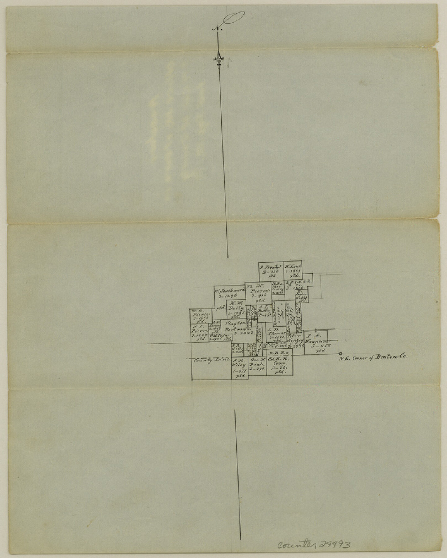
Grayson County Sketch File 20
[Sketch of surveys in southwest corner of county]
-
Map/Doc
24493
-
Collection
General Map Collection
-
Object Dates
1861/9/18 (Creation Date)
-
People and Organizations
Pressler (Surveyor/Engineer)
-
Counties
Grayson Denton
-
Subjects
Surveying Sketch File
-
Height x Width
10.1 x 8.1 inches
25.7 x 20.6 cm
-
Medium
paper, manuscript
Part of: General Map Collection
Flight Mission No. DIX-6P, Frame 189, Aransas County

Print $20.00
- Digital $50.00
Flight Mission No. DIX-6P, Frame 189, Aransas County
1956
Size 19.1 x 22.8 inches
Map/Doc 83851
Flight Mission No. CRC-3R, Frame 92, Chambers County

Print $20.00
- Digital $50.00
Flight Mission No. CRC-3R, Frame 92, Chambers County
1956
Size 18.5 x 22.3 inches
Map/Doc 84830
Clay County Sketch File 29

Print $16.00
- Digital $50.00
Clay County Sketch File 29
Size 11.3 x 8.7 inches
Map/Doc 18448
Matagorda County Sketch File 38

Print $20.00
- Digital $50.00
Matagorda County Sketch File 38
1904
Size 24.4 x 33.0 inches
Map/Doc 12046
Bee County Sketch File 25

Print $4.00
- Digital $50.00
Bee County Sketch File 25
1880
Size 11.0 x 8.2 inches
Map/Doc 14326
Hemphill County Boundary File 3

Print $36.00
- Digital $50.00
Hemphill County Boundary File 3
Size 7.7 x 32.9 inches
Map/Doc 54630
Lampasas County Working Sketch 3

Print $20.00
- Digital $50.00
Lampasas County Working Sketch 3
1941
Size 25.0 x 14.6 inches
Map/Doc 70280
Bexar County Sketch File 8

Print $4.00
- Digital $50.00
Bexar County Sketch File 8
Size 9.4 x 7.7 inches
Map/Doc 14477
Llano County Sketch File 15

Print $2.00
- Digital $50.00
Llano County Sketch File 15
Size 10.4 x 7.7 inches
Map/Doc 30391
Flight Mission No. BRA-16M, Frame 89, Jefferson County

Print $20.00
- Digital $50.00
Flight Mission No. BRA-16M, Frame 89, Jefferson County
1953
Size 18.6 x 22.4 inches
Map/Doc 85701
Martin County Boundary File 62a

Print $30.00
- Digital $50.00
Martin County Boundary File 62a
Size 12.8 x 8.3 inches
Map/Doc 56801
National Map Company's Ohio showing Counties, Townships, Cities, Villages, Post Offices, Steam and Electric Railways, With Stations and Distances Between Stations

Print $20.00
- Digital $50.00
National Map Company's Ohio showing Counties, Townships, Cities, Villages, Post Offices, Steam and Electric Railways, With Stations and Distances Between Stations
1920
Size 38.7 x 32.3 inches
Map/Doc 97109
You may also like
Flight Mission No. BRA-16M, Frame 126, Jefferson County

Print $20.00
- Digital $50.00
Flight Mission No. BRA-16M, Frame 126, Jefferson County
1953
Size 18.5 x 22.5 inches
Map/Doc 85736
Flight Mission No. DQO-6K, Frame 23, Galveston County

Print $20.00
- Digital $50.00
Flight Mission No. DQO-6K, Frame 23, Galveston County
1952
Size 18.8 x 22.5 inches
Map/Doc 85096
Dickens County Sketch File F1

Print $28.00
- Digital $50.00
Dickens County Sketch File F1
Size 11.4 x 8.7 inches
Map/Doc 20849
Val Verde County Working Sketch 72

Print $20.00
- Digital $50.00
Val Verde County Working Sketch 72
1967
Size 19.6 x 23.0 inches
Map/Doc 72207
Bee County Sketch File 5

Print $40.00
- Digital $50.00
Bee County Sketch File 5
Size 27.4 x 23.4 inches
Map/Doc 10914
Coleman County Sketch File 22

Print $10.00
- Digital $50.00
Coleman County Sketch File 22
1871
Size 8.4 x 7.9 inches
Map/Doc 18698
Hamilton County Working Sketch 27

Print $20.00
- Digital $50.00
Hamilton County Working Sketch 27
1975
Size 43.4 x 34.3 inches
Map/Doc 63365
Montgomery County Rolled Sketch 42

Print $20.00
- Digital $50.00
Montgomery County Rolled Sketch 42
1939
Size 14.1 x 20.3 inches
Map/Doc 6815
Shelby County Rolled Sketch 11

Print $20.00
- Digital $50.00
Shelby County Rolled Sketch 11
1945
Size 24.9 x 28.6 inches
Map/Doc 7779
Outer Continental Shelf Leasing Maps (Louisiana Offshore Operations)

Print $20.00
- Digital $50.00
Outer Continental Shelf Leasing Maps (Louisiana Offshore Operations)
1955
Size 15.9 x 10.8 inches
Map/Doc 76082
Waller County

Print $20.00
- Digital $50.00
Waller County
1945
Size 46.4 x 27.1 inches
Map/Doc 77449
The Republic County of Colorado. 1840

Print $20.00
The Republic County of Colorado. 1840
2020
Size 18.4 x 21.7 inches
Map/Doc 96122