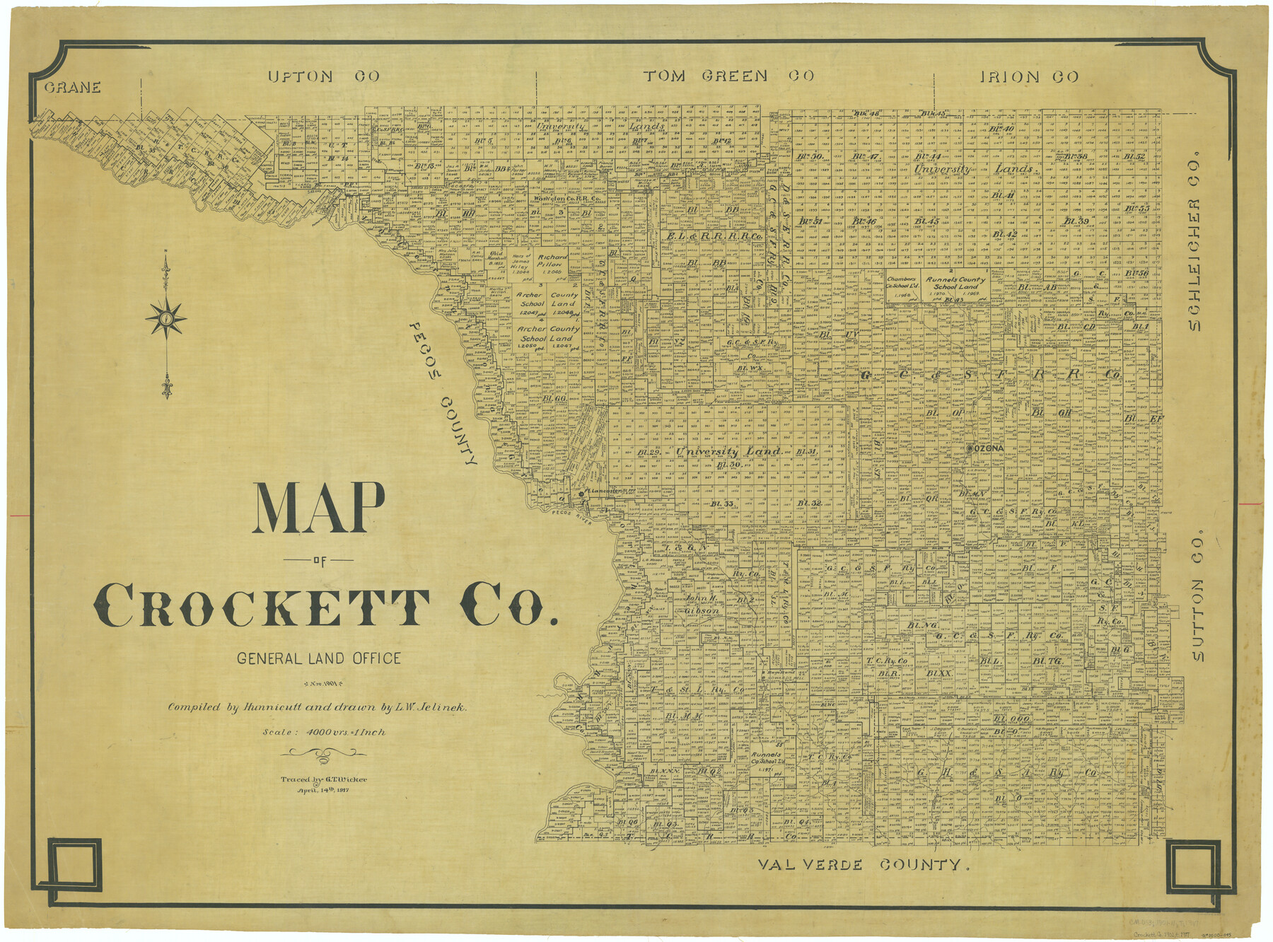
Map of Crockett Co.
-
Map/Doc
66791
-
Collection
General Map Collection
-
Object Dates
1901 (Creation Date)
-
People and Organizations
Texas General Land Office (Publisher)
Hunnicutt (Compiler)
L.W. Jelinek (Draftsman)
-
Counties
Crockett
-
Subjects
County
-
Height x Width
33.9 x 45.8 inches
86.1 x 116.3 cm
-
Comments
Traced April 14, 1917 by G. T. Wicker.
Part of: General Map Collection
Kinney County Sketch File B

Print $8.00
- Digital $50.00
Kinney County Sketch File B
1873
Size 11.9 x 8.1 inches
Map/Doc 29119
Real County Working Sketch 26

Print $20.00
- Digital $50.00
Real County Working Sketch 26
1947
Size 28.7 x 28.1 inches
Map/Doc 71918
Flight Mission No. BRA-7M, Frame 149, Jefferson County

Print $20.00
- Digital $50.00
Flight Mission No. BRA-7M, Frame 149, Jefferson County
1953
Size 18.7 x 22.5 inches
Map/Doc 85543

Polk County Sketch File 11

Print $4.00
- Digital $50.00
Polk County Sketch File 11
Size 9.2 x 8.1 inches
Map/Doc 34142
Edwards County Rolled Sketch 24

Print $20.00
- Digital $50.00
Edwards County Rolled Sketch 24
1953
Size 29.9 x 38.0 inches
Map/Doc 5810
Montgomery Co.

Print $40.00
- Digital $50.00
Montgomery Co.
1943
Size 45.2 x 54.8 inches
Map/Doc 95594
Culberson County Working Sketch 90

Print $20.00
- Digital $50.00
Culberson County Working Sketch 90
1992
Size 35.0 x 28.0 inches
Map/Doc 68544
Flight Mission No. BRA-7M, Frame 125, Jefferson County

Print $20.00
- Digital $50.00
Flight Mission No. BRA-7M, Frame 125, Jefferson County
1953
Size 16.3 x 16.1 inches
Map/Doc 85519
Uvalde County Sketch File 13

Print $20.00
- Digital $50.00
Uvalde County Sketch File 13
Size 14.3 x 29.1 inches
Map/Doc 12528

Freestone County

Print $40.00
- Digital $50.00
Freestone County
1918
Size 48.9 x 42.0 inches
Map/Doc 1831
You may also like
Andrews County Boundary File 2a

Print $14.00
- Digital $50.00
Andrews County Boundary File 2a
Size 11.2 x 8.9 inches
Map/Doc 49690
Uvalde County Working Sketch 53

Print $20.00
- Digital $50.00
Uvalde County Working Sketch 53
1982
Size 30.4 x 43.0 inches
Map/Doc 72123
Pecos County Boundary File 1a

Print $12.00
- Digital $50.00
Pecos County Boundary File 1a
Size 12.6 x 8.3 inches
Map/Doc 57855
[T.& P. RR Co. Block 32 Township 4 North]
![92455, [T.& P. RR Co. Block 32 Township 4 North], Twichell Survey Records](https://historictexasmaps.com/wmedia_w700/maps/92455-1.tif.jpg)
Print $20.00
- Digital $50.00
[T.& P. RR Co. Block 32 Township 4 North]
Size 35.5 x 19.5 inches
Map/Doc 92455
King County Boundary File 4

Print $58.00
- Digital $50.00
King County Boundary File 4
Size 14.1 x 8.7 inches
Map/Doc 64905
Fractional Township No. 1N and Township No. 2N R. No. 1E, Deaf Smith and Parmer Counties comprising Capitol Leagues 436, 437, 454, and 455 and parts of Capitol Leagues 433, 434, 435, 438, 453, 456, 457 and 458

Print $20.00
- Digital $50.00
Fractional Township No. 1N and Township No. 2N R. No. 1E, Deaf Smith and Parmer Counties comprising Capitol Leagues 436, 437, 454, and 455 and parts of Capitol Leagues 433, 434, 435, 438, 453, 456, 457 and 458
1906
Size 27.1 x 22.4 inches
Map/Doc 93965
Val Verde County Working Sketch 41

Print $20.00
- Digital $50.00
Val Verde County Working Sketch 41
1943
Size 27.8 x 30.2 inches
Map/Doc 72176
General Highway Map. Detail of Cities and Towns in Bell County, Texas [Killeen and Holland, etc.]
![79367, General Highway Map. Detail of Cities and Towns in Bell County, Texas [Killeen and Holland, etc.], Texas State Library and Archives](https://historictexasmaps.com/wmedia_w700/maps/79367.tif.jpg)
Print $20.00
General Highway Map. Detail of Cities and Towns in Bell County, Texas [Killeen and Holland, etc.]
1961
Size 18.2 x 25.0 inches
Map/Doc 79367
Wilbarger County Sketch File 6

Print $6.00
- Digital $50.00
Wilbarger County Sketch File 6
1874
Size 12.6 x 7.8 inches
Map/Doc 40172
Crockett County Working Sketch 33

Print $20.00
- Digital $50.00
Crockett County Working Sketch 33
1926
Size 27.0 x 32.8 inches
Map/Doc 68366
Brown County Sketch File 7

Print $6.00
- Digital $50.00
Brown County Sketch File 7
1860
Size 13.0 x 8.1 inches
Map/Doc 16590
The Republic County of Harrison. June 24, 1841

Print $20.00
The Republic County of Harrison. June 24, 1841
2020
Size 18.6 x 21.7 inches
Map/Doc 96171