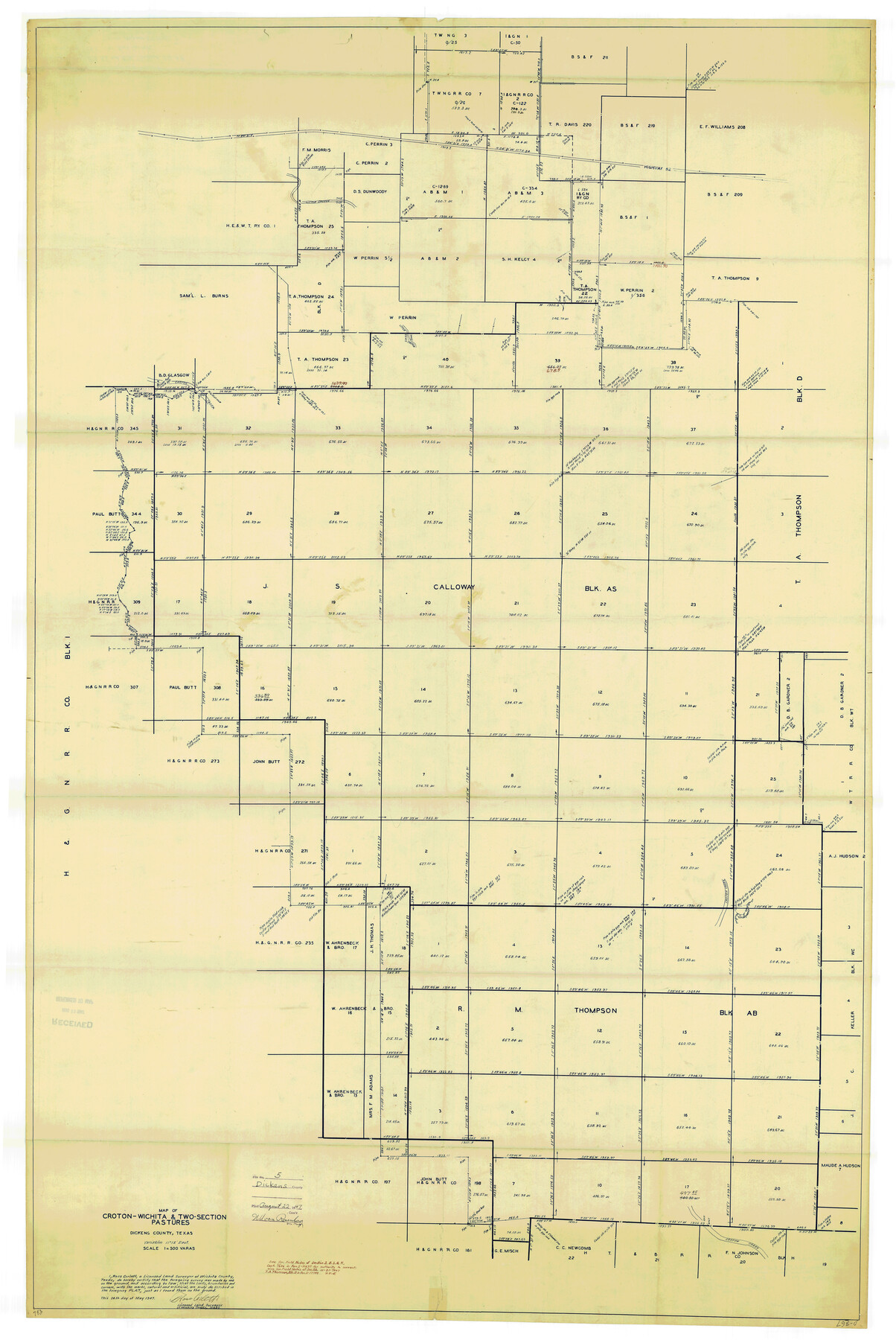
Dickens County Rolled Sketch 5
Map of Croton-Wichita & Two-section Pastures
-
Map/Doc
8787
-
Collection
General Map Collection
-
Object Dates
1947/5/24 (Creation Date)
1947/8/22 (File Date)
-
People and Organizations
Ross Corlett (Surveyor/Engineer)
-
Counties
Dickens
-
Subjects
Surveying Rolled Sketch
-
Height x Width
60.2 x 40.3 inches
152.9 x 102.4 cm
-
Medium
blueprint/diazo
-
Scale
1" = 500 varas
-
Comments
See Dickens County Sketch File 33 (21025) for report.
Related maps
Dickens County Sketch File 33

Print $10.00
- Digital $50.00
Dickens County Sketch File 33
1947
Size 14.5 x 9.1 inches
Map/Doc 21025
Dickens County Rolled Sketch 8

Print $20.00
- Digital $50.00
Dickens County Rolled Sketch 8
1953
Size 42.9 x 23.7 inches
Map/Doc 5707
Part of: General Map Collection
Presidio County Rolled Sketch T-1

Print $20.00
- Digital $50.00
Presidio County Rolled Sketch T-1
Size 26.8 x 27.1 inches
Map/Doc 7416
Brazoria County Sketch File 20

Print $40.00
- Digital $50.00
Brazoria County Sketch File 20
1853
Size 22.3 x 15.0 inches
Map/Doc 10953
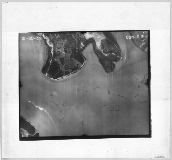
San Patricio County Rolled Sketch 47
Print $20.00
- Digital $50.00
San Patricio County Rolled Sketch 47
1939
Size 27.6 x 29.6 inches
Map/Doc 7731
Cottle County Rolled Sketch 5

Print $20.00
- Digital $50.00
Cottle County Rolled Sketch 5
1911
Size 31.0 x 41.1 inches
Map/Doc 8672
Flight Mission No. CRC-4R, Frame 109, Chambers County

Print $20.00
- Digital $50.00
Flight Mission No. CRC-4R, Frame 109, Chambers County
1956
Size 18.5 x 22.5 inches
Map/Doc 84906
Map of Asylum & University lands situated on the waters of Hubbards Creek

Print $20.00
- Digital $50.00
Map of Asylum & University lands situated on the waters of Hubbards Creek
1857
Size 21.2 x 28.5 inches
Map/Doc 2491
Pecos County Rolled Sketch 165

Print $20.00
- Digital $50.00
Pecos County Rolled Sketch 165
1966
Size 23.4 x 19.6 inches
Map/Doc 7290
Flight Mission No. DAG-23K, Frame 182, Matagorda County

Print $20.00
- Digital $50.00
Flight Mission No. DAG-23K, Frame 182, Matagorda County
1953
Size 18.5 x 22.3 inches
Map/Doc 86517
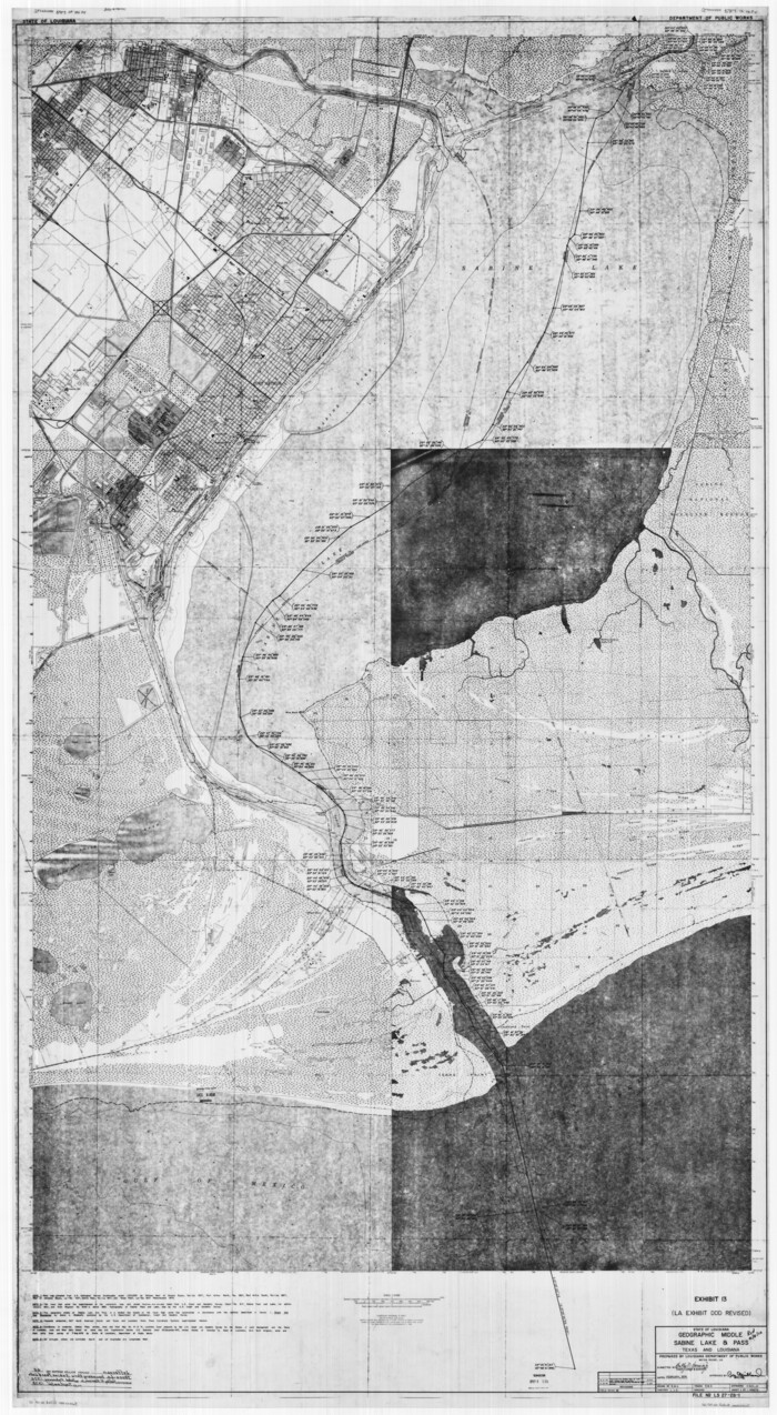
Jefferson County Rolled Sketch 62
Print $40.00
- Digital $50.00
Jefferson County Rolled Sketch 62
1974
Size 78.4 x 43.1 inches
Map/Doc 9318
Orange County Working Sketch 22

Print $20.00
- Digital $50.00
Orange County Working Sketch 22
1939
Size 35.8 x 35.5 inches
Map/Doc 71354
Kimble County Working Sketch 39

Print $20.00
- Digital $50.00
Kimble County Working Sketch 39
1947
Size 30.8 x 23.5 inches
Map/Doc 70107
Harris County Historic Topographic C

Print $20.00
- Digital $50.00
Harris County Historic Topographic C
1916
Size 25.5 x 19.1 inches
Map/Doc 65851
You may also like
Duval County Rolled Sketch 35

Print $20.00
- Digital $50.00
Duval County Rolled Sketch 35
1951
Size 23.5 x 17.0 inches
Map/Doc 5750
San Patricio County Rolled Sketch 25

Print $40.00
- Digital $50.00
San Patricio County Rolled Sketch 25
1925
Size 37.2 x 54.1 inches
Map/Doc 9887
Trinity River, Hutchins Bridge Sheet

Print $20.00
- Digital $50.00
Trinity River, Hutchins Bridge Sheet
1922
Size 38.6 x 33.2 inches
Map/Doc 65190
Flight Mission No. DQO-8K, Frame 56, Galveston County

Print $20.00
- Digital $50.00
Flight Mission No. DQO-8K, Frame 56, Galveston County
1952
Size 18.7 x 17.6 inches
Map/Doc 85163
Sutton County Boundary File 4

Print $20.00
- Digital $50.00
Sutton County Boundary File 4
Size 14.2 x 8.8 inches
Map/Doc 59035
Tom Green County Rolled Sketch 21

Print $20.00
- Digital $50.00
Tom Green County Rolled Sketch 21
Size 20.2 x 12.9 inches
Map/Doc 8004

El Paso County Boundary File 26

Print $14.00
- Digital $50.00
El Paso County Boundary File 26
Size 14.8 x 9.3 inches
Map/Doc 53231
Montgomery County Sketch File 26

Print $6.00
- Digital $50.00
Montgomery County Sketch File 26
1845
Size 13.4 x 11.4 inches
Map/Doc 31871
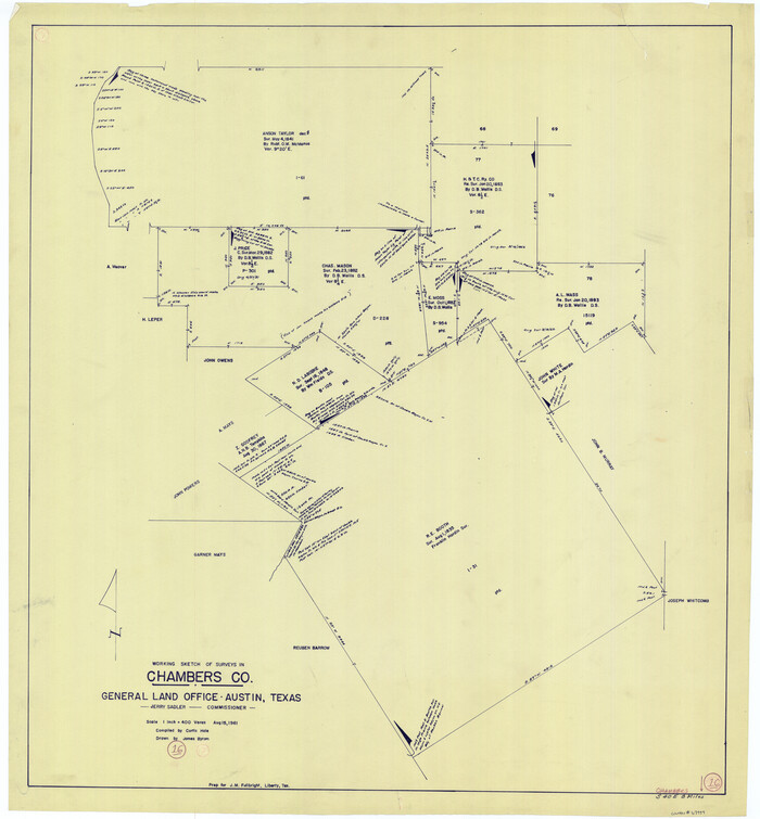
Chambers County Working Sketch 16
Print $20.00
- Digital $50.00
Chambers County Working Sketch 16
1961
Size 32.8 x 30.4 inches
Map/Doc 67999

