Brazoria County Sketch File 20
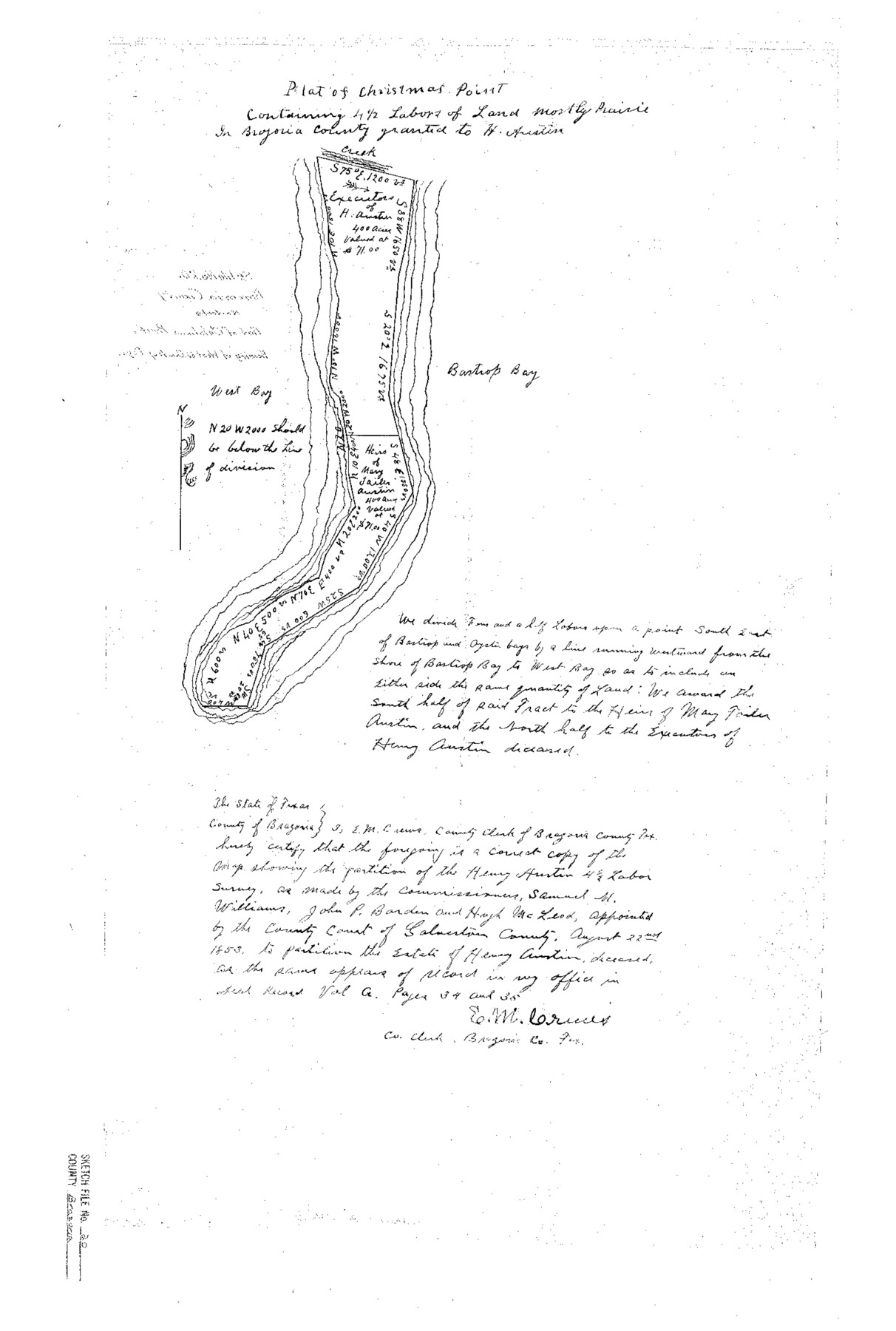
Plat of Christmas Point containing 4 1/2 labors of land mostly prairie in Brazoria County granted to H. Austin
-
Map/Doc
10953
-
Collection
General Map Collection
-
Object Dates
1853/8/22 (Creation Date)
-
People and Organizations
Samuel M. Williams (Surveyor/Engineer)
John P. Borden (Surveyor/Engineer)
Hugh McLeod (Surveyor/Engineer)
E.M. Crews (County/Other Clerk)
-
Counties
Brazoria
-
Subjects
Surveying Sketch File
-
Height x Width
22.3 x 15.0 inches
56.6 x 38.1 cm
-
Medium
linen, non-manuscript
-
Features
Christmas Point
West Bay
Bastrop Bay
Oyster Bay
Part of: General Map Collection
McCulloch County Sketch File 1

Print $4.00
- Digital $50.00
McCulloch County Sketch File 1
1854
Size 8.7 x 6.8 inches
Map/Doc 31165
Flight Mission No. DQO-1K, Frame 146, Galveston County

Print $20.00
- Digital $50.00
Flight Mission No. DQO-1K, Frame 146, Galveston County
1952
Size 18.9 x 22.5 inches
Map/Doc 84999

Hamilton County Boundary File 3

Print $52.00
- Digital $50.00
Hamilton County Boundary File 3
Size 14.2 x 8.8 inches
Map/Doc 54197
[Cotton Belt, St. Louis Southwestern Railway of Texas, Alignment through Smith County]
![64386, [Cotton Belt, St. Louis Southwestern Railway of Texas, Alignment through Smith County], General Map Collection](https://historictexasmaps.com/wmedia_w700/maps/64386.tif.jpg)
Print $20.00
- Digital $50.00
[Cotton Belt, St. Louis Southwestern Railway of Texas, Alignment through Smith County]
1903
Size 21.7 x 29.3 inches
Map/Doc 64386
Floyd County Boundary File 2b

Print $40.00
- Digital $50.00
Floyd County Boundary File 2b
Size 38.9 x 20.1 inches
Map/Doc 53490
Montgomery County Sketch File 20

Print $38.00
- Digital $50.00
Montgomery County Sketch File 20
1932
Size 14.3 x 8.8 inches
Map/Doc 31847
Edwards County Working Sketch 74

Print $20.00
- Digital $50.00
Edwards County Working Sketch 74
1959
Size 23.6 x 38.4 inches
Map/Doc 68950
El Paso County Rolled Sketch 43B

Print $20.00
- Digital $50.00
El Paso County Rolled Sketch 43B
Size 22.0 x 22.0 inches
Map/Doc 5830
Lampasas County

Print $20.00
- Digital $50.00
Lampasas County
1972
Size 35.6 x 44.6 inches
Map/Doc 95565
Val Verde County Rolled Sketch 69A

Print $40.00
- Digital $50.00
Val Verde County Rolled Sketch 69A
1942
Size 11.0 x 139.1 inches
Map/Doc 10086
Coryell County Sketch File 19

Print $20.00
- Digital $50.00
Coryell County Sketch File 19
Size 14.8 x 12.4 inches
Map/Doc 19380
You may also like
Map of Lands in Pecos County, Texas, Block 1, I. and G. N. RR. Company

Print $20.00
- Digital $50.00
Map of Lands in Pecos County, Texas, Block 1, I. and G. N. RR. Company
1934
Size 21.9 x 16.8 inches
Map/Doc 91640
Anton Townsite Situated on Parts of Sections 106 and 113 Block A, R. M. Thomson, Grantee Hockley County, Texas

Print $20.00
- Digital $50.00
Anton Townsite Situated on Parts of Sections 106 and 113 Block A, R. M. Thomson, Grantee Hockley County, Texas
Size 30.7 x 34.5 inches
Map/Doc 92217
Flight Mission No. BRA-8M, Frame 87, Jefferson County

Print $20.00
- Digital $50.00
Flight Mission No. BRA-8M, Frame 87, Jefferson County
1953
Size 18.6 x 22.3 inches
Map/Doc 85607
Foard County Working Sketch 10

Print $20.00
- Digital $50.00
Foard County Working Sketch 10
1977
Size 32.0 x 43.7 inches
Map/Doc 69201
Hopkins County Boundary File 3a

Print $4.00
- Digital $50.00
Hopkins County Boundary File 3a
Size 10.7 x 8.7 inches
Map/Doc 55082
Comanche County Working Sketch 7

Print $20.00
- Digital $50.00
Comanche County Working Sketch 7
1950
Size 27.3 x 30.6 inches
Map/Doc 68141
Harrison County Working Sketch 12

Print $20.00
- Digital $50.00
Harrison County Working Sketch 12
1960
Size 26.6 x 31.4 inches
Map/Doc 66032
Somervell County Working Sketch 7

Print $20.00
- Digital $50.00
Somervell County Working Sketch 7
2008
Size 27.9 x 34.2 inches
Map/Doc 88889
Garza County Working Sketch 4

Print $20.00
- Digital $50.00
Garza County Working Sketch 4
1916
Size 19.5 x 23.1 inches
Map/Doc 63151
Crane County Sketch File 20

Print $8.00
- Digital $50.00
Crane County Sketch File 20
1928
Size 11.0 x 8.5 inches
Map/Doc 19586
Coke County Working Sketch 15

Print $20.00
- Digital $50.00
Coke County Working Sketch 15
1948
Size 25.7 x 21.7 inches
Map/Doc 68052
Bowie County Rolled Sketch 1

Print $20.00
- Digital $50.00
Bowie County Rolled Sketch 1
1965
Size 32.0 x 46.1 inches
Map/Doc 8927