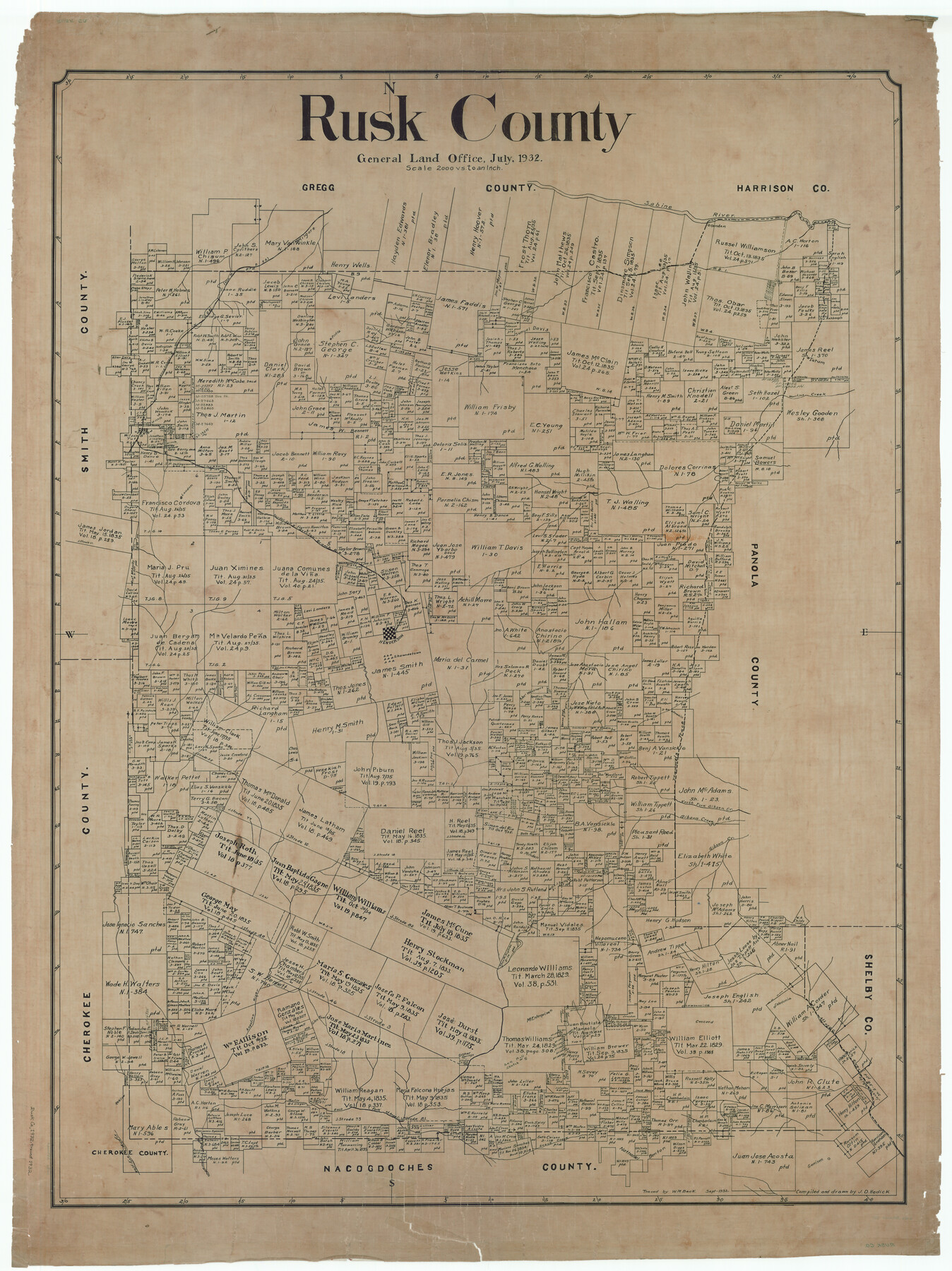
Rusk County
-
Map/Doc
63011
-
Collection
General Map Collection
-
Object Dates
7/1932 (Creation Date)
9/1932 (Tracing Date)
-
People and Organizations
Texas General Land Office (Publisher)
John D. Hedick (Draftsman)
W.M. Beck (Tracer)
-
Counties
Rusk
-
Subjects
County
-
Height x Width
49.9 x 37.4 inches
126.8 x 95.0 cm
Part of: General Map Collection
McMullen County Sketch File 36

Print $8.00
- Digital $50.00
McMullen County Sketch File 36
Size 4.8 x 8.2 inches
Map/Doc 31406
Palo Pinto County Sketch File 25a

Print $6.00
- Digital $50.00
Palo Pinto County Sketch File 25a
Size 11.0 x 11.4 inches
Map/Doc 33417
PSL Field Notes for Blocks 1 and 2, Hansford and Sherman Counties, Blocks 3 and 4, Hansford County, Blocks A1, A2, A4, A5, and A6 in Hartley County, Block C0 in Hockley, Lubbock, Lynn, and Terry Counties, and Blocks A and B in Kent County

PSL Field Notes for Blocks 1 and 2, Hansford and Sherman Counties, Blocks 3 and 4, Hansford County, Blocks A1, A2, A4, A5, and A6 in Hartley County, Block C0 in Hockley, Lubbock, Lynn, and Terry Counties, and Blocks A and B in Kent County
Map/Doc 81655
Mills County Working Sketch 28

Print $40.00
- Digital $50.00
Mills County Working Sketch 28
2006
Size 42.0 x 67.4 inches
Map/Doc 85385
Zavala County Sketch File 18

Print $16.00
- Digital $50.00
Zavala County Sketch File 18
1897
Size 14.0 x 9.1 inches
Map/Doc 41356
Rusk County Rolled Sketch 4

Print $20.00
- Digital $50.00
Rusk County Rolled Sketch 4
1895
Size 47.8 x 33.9 inches
Map/Doc 9874
Denton County Sketch File 36a

Print $6.00
- Digital $50.00
Denton County Sketch File 36a
1898
Size 11.3 x 9.1 inches
Map/Doc 20773
Gaines County Working Sketch 6

Print $20.00
- Digital $50.00
Gaines County Working Sketch 6
1940
Size 25.0 x 40.8 inches
Map/Doc 69306
Map of Concho County

Print $20.00
- Digital $50.00
Map of Concho County
1879
Size 23.4 x 18.3 inches
Map/Doc 4523
Map of Grimes Co.

Print $20.00
- Digital $50.00
Map of Grimes Co.
1881
Size 32.6 x 17.5 inches
Map/Doc 66843
Map of the County of Calhoun

Print $20.00
- Digital $50.00
Map of the County of Calhoun
1852
Size 21.0 x 20.4 inches
Map/Doc 4431
Kent County Boundary File 12

Print $30.00
- Digital $50.00
Kent County Boundary File 12
Size 10.5 x 8.2 inches
Map/Doc 55897
You may also like
Martha's Vineyard to Block Island Including Western Approach to Cape Cod Canal

Print $20.00
- Digital $50.00
Martha's Vineyard to Block Island Including Western Approach to Cape Cod Canal
1963
Size 37.5 x 45.7 inches
Map/Doc 73554
Williamson County Working Sketch 2

Print $20.00
- Digital $50.00
Williamson County Working Sketch 2
1915
Size 22.7 x 17.9 inches
Map/Doc 72562
Map of La Salle County

Print $20.00
- Digital $50.00
Map of La Salle County
1878
Size 29.8 x 24.8 inches
Map/Doc 3798
Limestone County Sketch File 17

Print $10.00
- Digital $50.00
Limestone County Sketch File 17
Size 14.4 x 8.7 inches
Map/Doc 30187
Flight Mission No. DQO-7K, Frame 82, Galveston County

Print $20.00
- Digital $50.00
Flight Mission No. DQO-7K, Frame 82, Galveston County
1952
Size 18.8 x 22.5 inches
Map/Doc 85109
Jack County Boundary File 1a

Print $16.00
- Digital $50.00
Jack County Boundary File 1a
Size 10.7 x 8.4 inches
Map/Doc 55376
La Salle County Sketch File 9

Print $4.00
- Digital $50.00
La Salle County Sketch File 9
Size 6.3 x 8.3 inches
Map/Doc 29458
Waller County Sketch File 2

Print $52.00
- Digital $50.00
Waller County Sketch File 2
Size 13.3 x 9.0 inches
Map/Doc 39570
Upton County Rolled Sketch 3

Print $20.00
- Digital $50.00
Upton County Rolled Sketch 3
Size 30.3 x 34.1 inches
Map/Doc 8066
Houston County

Print $20.00
- Digital $50.00
Houston County
1868
Size 24.3 x 25.0 inches
Map/Doc 4568
Potter County Boundary File 1a

Print $10.00
- Digital $50.00
Potter County Boundary File 1a
Size 14.1 x 8.8 inches
Map/Doc 57943
Map of Gillespie County

Print $20.00
- Digital $50.00
Map of Gillespie County
1857
Size 35.1 x 26.2 inches
Map/Doc 3582