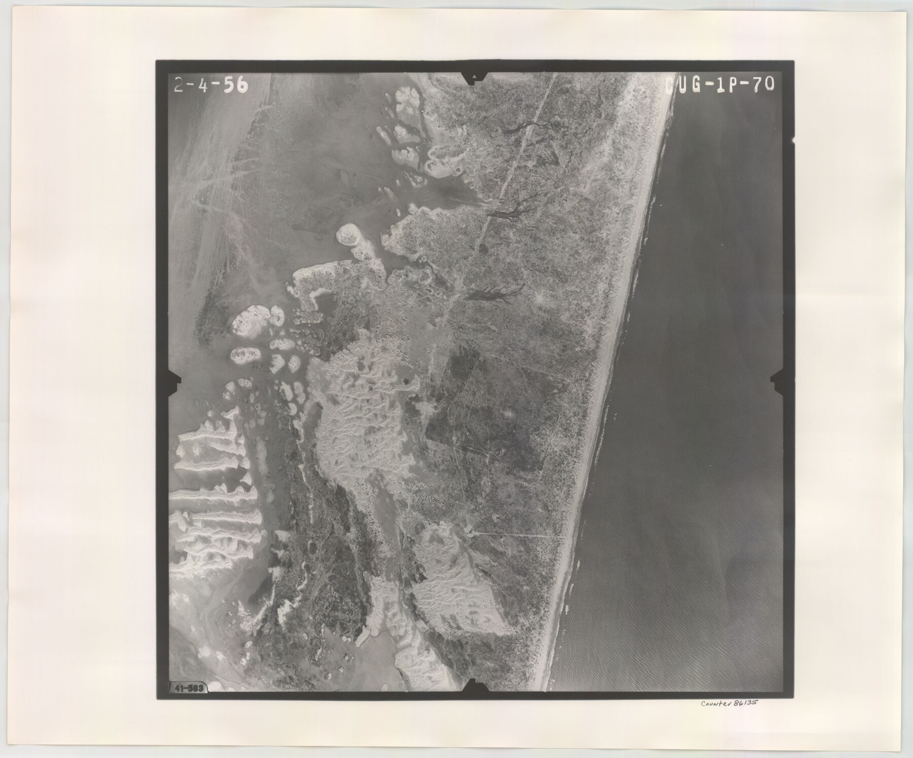
Flight Mission No. CUG-1P, Frame 70, Kleberg County
CUG-1P-70
-
Map/Doc
86135
-
Collection
General Map Collection
-
Object Dates
1956/2/4 (Creation Date)
-
People and Organizations
U. S. Department of Agriculture (Publisher)
-
Counties
Kleberg
-
Subjects
Aerial Photograph
-
Height x Width
18.5 x 22.3 inches
47.0 x 56.6 cm
-
Comments
Flown by V. L. Beavers and Associates of San Antonio, Texas.
Part of: General Map Collection
Runnels County Rolled Sketch 48

Print $20.00
- Digital $50.00
Runnels County Rolled Sketch 48
Size 32.4 x 36.7 inches
Map/Doc 7533
Dawson County

Print $20.00
- Digital $50.00
Dawson County
1900
Size 40.5 x 36.3 inches
Map/Doc 66798
Sabine Bank to East Bay including Heald Bank

Print $20.00
- Digital $50.00
Sabine Bank to East Bay including Heald Bank
1946
Size 44.8 x 33.9 inches
Map/Doc 69845
Hunt County Sketch File 20

Print $4.00
- Digital $50.00
Hunt County Sketch File 20
1853
Size 8.3 x 7.9 inches
Map/Doc 27120
[Pecos River Bed]
![2467, [Pecos River Bed], General Map Collection](https://historictexasmaps.com/wmedia_w700/maps/2467.tif.jpg)
Print $20.00
- Digital $50.00
[Pecos River Bed]
Size 16.6 x 39.8 inches
Map/Doc 2467
[Sketch for Mineral Application 15273 - Sabine River Bed]
![65576, [Sketch for Mineral Application 15273 - Sabine River Bed], General Map Collection](https://historictexasmaps.com/wmedia_w700/maps/65576.tif.jpg)
Print $20.00
- Digital $50.00
[Sketch for Mineral Application 15273 - Sabine River Bed]
1926
Size 45.4 x 28.1 inches
Map/Doc 65576
Eastland County Working Sketch 13

Print $20.00
- Digital $50.00
Eastland County Working Sketch 13
1919
Size 34.0 x 38.0 inches
Map/Doc 68794
Edwards County Working Sketch 35

Print $20.00
- Digital $50.00
Edwards County Working Sketch 35
1948
Size 20.9 x 31.1 inches
Map/Doc 68911
Brazos Santiago, Texas

Print $20.00
- Digital $50.00
Brazos Santiago, Texas
1867
Size 25.1 x 18.3 inches
Map/Doc 72988
Potter County Sketch File 1

Print $28.00
- Digital $50.00
Potter County Sketch File 1
1882
Size 7.4 x 8.8 inches
Map/Doc 34378
Topographical Map of the Rio Grande from Roma to the Gulf of Mexico, Index Map, Sheet No. 2

Print $20.00
- Digital $50.00
Topographical Map of the Rio Grande from Roma to the Gulf of Mexico, Index Map, Sheet No. 2
1912
Map/Doc 89524
Starr County Rolled Sketch 46A

Print $20.00
- Digital $50.00
Starr County Rolled Sketch 46A
1986
Size 17.9 x 34.4 inches
Map/Doc 7837
You may also like
Wheeler County Sketch File 5

Print $40.00
- Digital $50.00
Wheeler County Sketch File 5
1887
Size 20.2 x 24.2 inches
Map/Doc 12675
Roberts County Working Sketch 11

Print $40.00
- Digital $50.00
Roberts County Working Sketch 11
1966
Size 57.6 x 38.6 inches
Map/Doc 63537
King County Boundary File 5b

Print $25.00
- Digital $50.00
King County Boundary File 5b
Size 8.7 x 6.9 inches
Map/Doc 64924
Cottle County Rolled Sketch 14

Print $741.00
- Digital $50.00
Cottle County Rolled Sketch 14
1882
Size 10.8 x 16.0 inches
Map/Doc 42369
[Public School Land Blocks]
![93153, [Public School Land Blocks], Twichell Survey Records](https://historictexasmaps.com/wmedia_w700/maps/93153-1.tif.jpg)
Print $40.00
- Digital $50.00
[Public School Land Blocks]
Size 56.3 x 74.8 inches
Map/Doc 93153
Flight Mission No. DQO-2K, Frame 137, Galveston County

Print $20.00
- Digital $50.00
Flight Mission No. DQO-2K, Frame 137, Galveston County
1952
Size 18.8 x 22.5 inches
Map/Doc 85034
Hardin County Working Sketch 31

Print $20.00
- Digital $50.00
Hardin County Working Sketch 31
1971
Size 43.0 x 33.2 inches
Map/Doc 63429
Panola County, Texas

Print $20.00
- Digital $50.00
Panola County, Texas
1879
Size 18.0 x 19.4 inches
Map/Doc 654
Motley County Sketch File 16 (N)

Print $16.00
- Digital $50.00
Motley County Sketch File 16 (N)
1911
Size 11.0 x 8.6 inches
Map/Doc 32052
San Jacinto County Working Sketch 27

Print $20.00
- Digital $50.00
San Jacinto County Working Sketch 27
1944
Size 30.5 x 23.3 inches
Map/Doc 63740
Travis County Working Sketch 14

Print $20.00
- Digital $50.00
Travis County Working Sketch 14
1937
Size 26.3 x 27.2 inches
Map/Doc 69398
Cameron County Rolled Sketch 19

Print $20.00
- Digital $50.00
Cameron County Rolled Sketch 19
1937
Size 26.0 x 21.8 inches
Map/Doc 5470