Potter County Sketch File 1
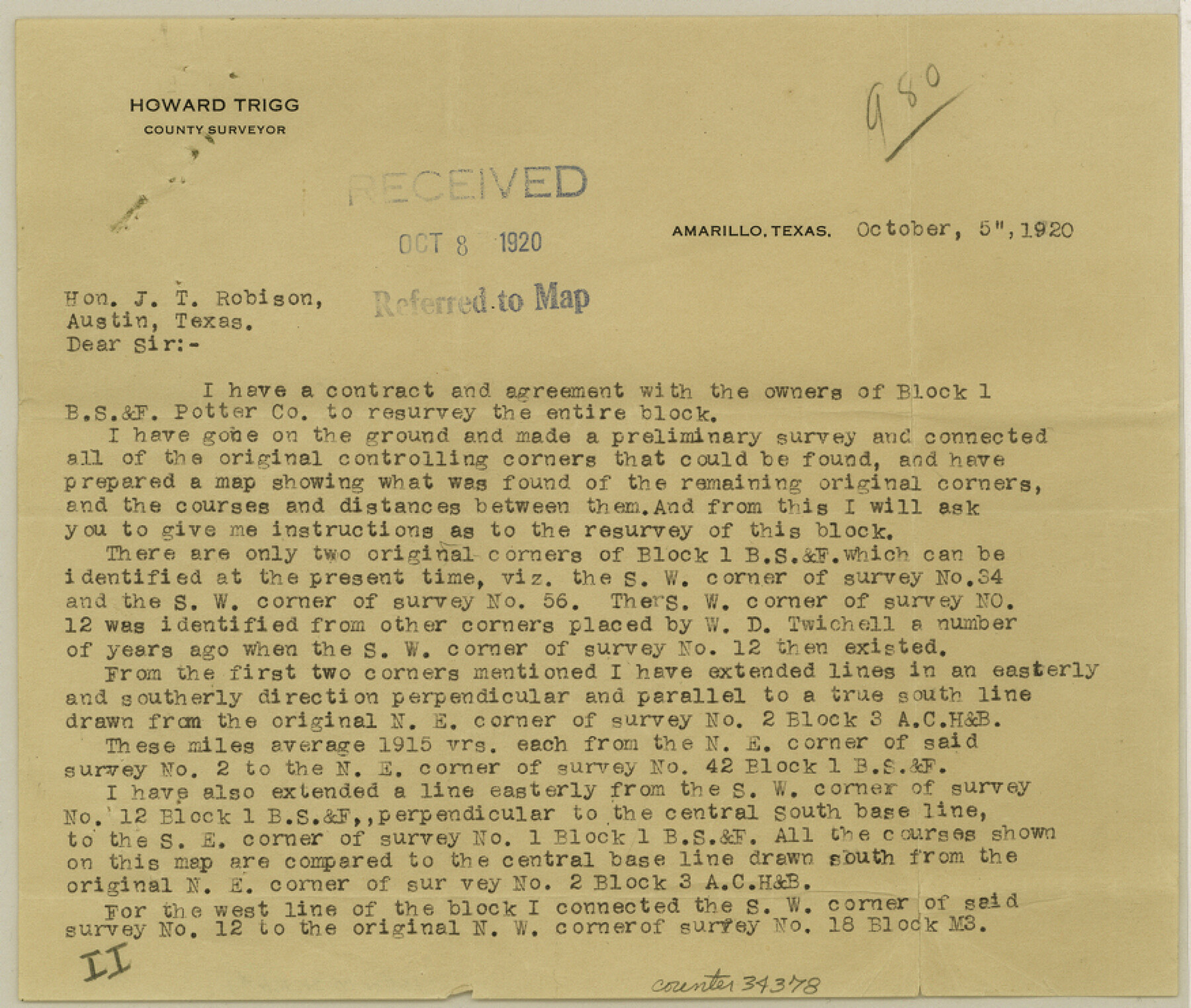
[Correspondence regarding a resurvey of Block 1, and sketch of northern half of Potter and surrounding counties]
-
Map/Doc
34378
-
Collection
General Map Collection
-
Object Dates
7/26/1882 (Creation Date)
10/5/1920 (Correspondence Date)
-
People and Organizations
W.D. Twichell (Surveyor/Engineer)
Howard T. Trigg (Surveyor/Engineer)
-
Counties
Potter Moore Hartley Oldham Hutchinson
-
Subjects
Surveying Sketch File
-
Height x Width
7.4 x 8.8 inches
18.8 x 22.4 cm
-
Medium
paper, manuscript
Part of: General Map Collection
Comanche County Working Sketch 2

Print $20.00
- Digital $50.00
Comanche County Working Sketch 2
1918
Size 15.0 x 21.5 inches
Map/Doc 68136
Copy of Surveyor's Field Book, Morris Browning - In Blocks 7, 5 & 4, I&GNRRCo., Hutchinson and Carson Counties, Texas

Print $2.00
- Digital $50.00
Copy of Surveyor's Field Book, Morris Browning - In Blocks 7, 5 & 4, I&GNRRCo., Hutchinson and Carson Counties, Texas
1888
Size 7.0 x 8.9 inches
Map/Doc 62261
Castro County Working Sketch 2

Print $20.00
- Digital $50.00
Castro County Working Sketch 2
Size 30.4 x 26.2 inches
Map/Doc 67897
United States - Gulf Coast - Galveston to Rio Grande

Print $20.00
- Digital $50.00
United States - Gulf Coast - Galveston to Rio Grande
1919
Size 26.5 x 18.2 inches
Map/Doc 72747
South Part Presidio County

Print $20.00
- Digital $50.00
South Part Presidio County
1975
Size 34.0 x 39.3 inches
Map/Doc 73266
Houston County

Print $20.00
- Digital $50.00
Houston County
1888
Size 24.5 x 26.1 inches
Map/Doc 3683
Township No. 4 South Range No. 19 West of the Indian Meridian

Print $20.00
- Digital $50.00
Township No. 4 South Range No. 19 West of the Indian Meridian
1875
Size 19.1 x 24.5 inches
Map/Doc 75183
Map of Marion County

Print $20.00
- Digital $50.00
Map of Marion County
1920
Size 29.6 x 42.7 inches
Map/Doc 66917
Bandera County Working Sketch 16b

Print $20.00
- Digital $50.00
Bandera County Working Sketch 16b
1941
Size 18.9 x 23.1 inches
Map/Doc 67610
Tom Green County Rolled Sketch 15

Print $20.00
- Digital $50.00
Tom Green County Rolled Sketch 15
Size 38.7 x 43.1 inches
Map/Doc 10002
Texas-Oklahoma (Indian Territory) Gainesville Quadrangle

Print $20.00
- Digital $50.00
Texas-Oklahoma (Indian Territory) Gainesville Quadrangle
1902
Size 21.2 x 17.2 inches
Map/Doc 75101
Flight Mission No. DQO-3K, Frame 26, Galveston County

Print $20.00
- Digital $50.00
Flight Mission No. DQO-3K, Frame 26, Galveston County
1952
Size 17.4 x 18.9 inches
Map/Doc 85067
You may also like
Hudspeth County Rolled Sketch 66

Print $20.00
- Digital $50.00
Hudspeth County Rolled Sketch 66
1973
Size 11.7 x 18.2 inches
Map/Doc 6263
Flight Mission No. BRA-8M, Frame 147, Jefferson County

Print $20.00
- Digital $50.00
Flight Mission No. BRA-8M, Frame 147, Jefferson County
1953
Size 16.0 x 15.9 inches
Map/Doc 85639
Map of Tyler County, Texas

Print $20.00
- Digital $50.00
Map of Tyler County, Texas
1879
Size 28.6 x 22.8 inches
Map/Doc 720
San Patricio County Rolled Sketch 29C

Print $40.00
- Digital $50.00
San Patricio County Rolled Sketch 29C
Size 49.1 x 61.4 inches
Map/Doc 48871
Garza County Sketch File 7

Print $4.00
- Digital $50.00
Garza County Sketch File 7
1900
Size 13.3 x 8.5 inches
Map/Doc 24060
Angelina County Sketch File 22

Print $8.00
- Digital $50.00
Angelina County Sketch File 22
1891
Size 14.0 x 8.7 inches
Map/Doc 13049
Flight Mission No. DIX-10P, Frame 62, Aransas County

Print $20.00
- Digital $50.00
Flight Mission No. DIX-10P, Frame 62, Aransas County
1956
Size 18.8 x 22.4 inches
Map/Doc 83923
Zavalla County

Print $20.00
- Digital $50.00
Zavalla County
1879
Size 21.3 x 25.0 inches
Map/Doc 4645
Liberty County Sketch File 18

Print $6.00
- Digital $50.00
Liberty County Sketch File 18
1859
Size 8.0 x 9.2 inches
Map/Doc 29920
Bexar County Boundary File 1

Print $26.00
- Digital $50.00
Bexar County Boundary File 1
Size 14.6 x 9.1 inches
Map/Doc 50505
Henderson County Working Sketch 3

Print $20.00
- Digital $50.00
Henderson County Working Sketch 3
Size 28.5 x 38.3 inches
Map/Doc 66136
Johnson County Sketch File 22

Print $20.00
- Digital $50.00
Johnson County Sketch File 22
1873
Size 18.8 x 16.2 inches
Map/Doc 11891