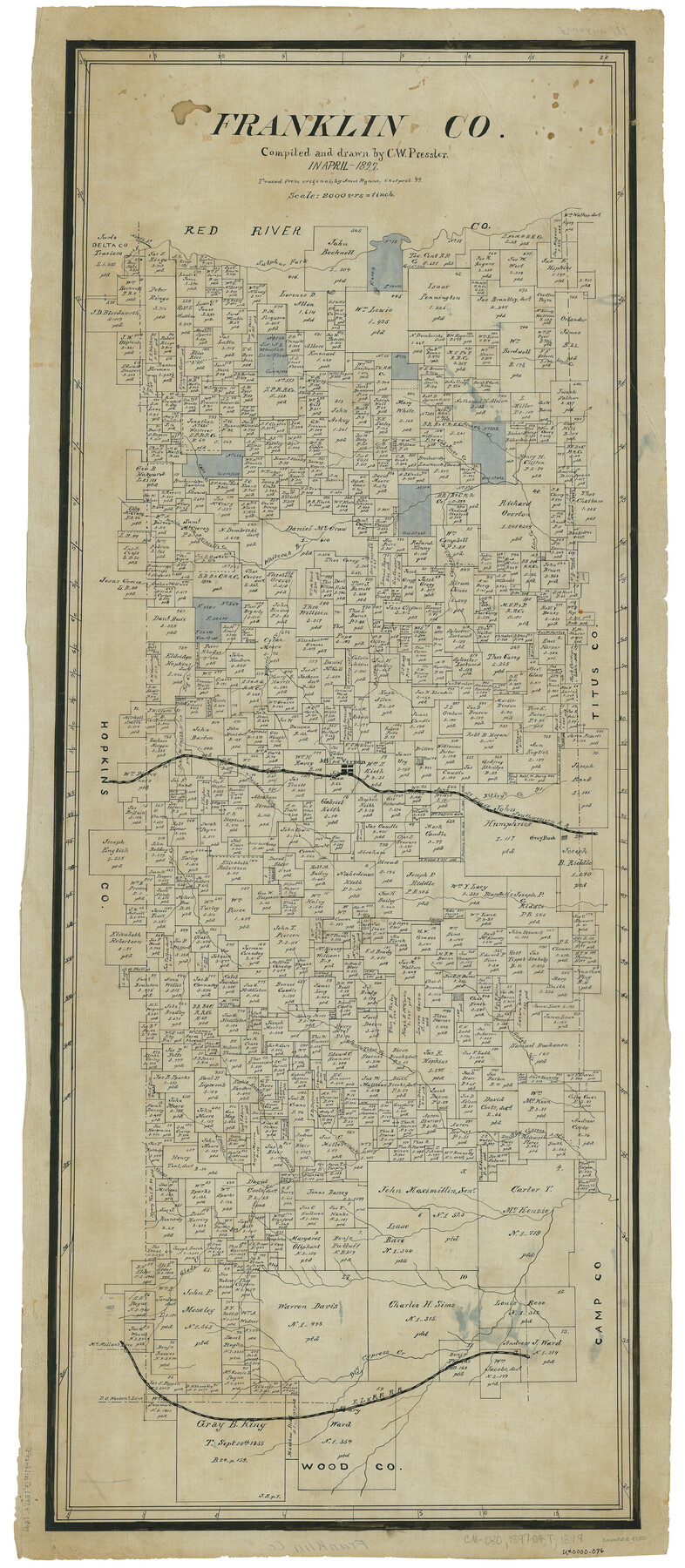
Franklin Co.
-
Map/Doc
4950
-
Collection
General Map Collection
-
Object Dates
4/1897 (Creation Date)
4/1899 (Tracing Date)
-
People and Organizations
Chas. W. Pressler (Draftsman)
Amos Wynne (Tracer)
-
Counties
Franklin
-
Subjects
County
-
Height x Width
36.5 x 16.0 inches
92.7 x 40.6 cm
-
Comments
Traced in April 1899 by Amos Wynne.
Part of: General Map Collection
Liberty County Rolled Sketch O

Print $40.00
- Digital $50.00
Liberty County Rolled Sketch O
1954
Size 44.3 x 53.7 inches
Map/Doc 10183
Right of Way Location Map, San Antonio & Aransas Pass, Station 656…

Print $4.00
- Digital $50.00
Right of Way Location Map, San Antonio & Aransas Pass, Station 656…
1919
Size 11.8 x 18.6 inches
Map/Doc 62567
Map of the Straits of Florida and Gulf of Mexico

Print $20.00
- Digital $50.00
Map of the Straits of Florida and Gulf of Mexico
1851
Size 18.3 x 27.4 inches
Map/Doc 72675
Archer County Rolled Sketch 10

Print $20.00
- Digital $50.00
Archer County Rolled Sketch 10
2012
Size 19.2 x 24.6 inches
Map/Doc 93326
Nueces County Sketch File 57

Print $20.00
- Digital $50.00
Nueces County Sketch File 57
1884
Size 11.1 x 8.7 inches
Map/Doc 32910
Briscoe County Sketch File 3

Print $40.00
- Digital $50.00
Briscoe County Sketch File 3
1885
Size 22.6 x 20.7 inches
Map/Doc 10992
Real County Working Sketch 49

Print $20.00
- Digital $50.00
Real County Working Sketch 49
1957
Size 25.9 x 25.7 inches
Map/Doc 71941
Foard County Sketch File 23

Print $32.00
- Digital $50.00
Foard County Sketch File 23
Size 11.3 x 9.0 inches
Map/Doc 22846
Crockett County Rolled Sketch 62

Print $20.00
- Digital $50.00
Crockett County Rolled Sketch 62
1947
Size 27.0 x 38.1 inches
Map/Doc 5605
Concho, San Saba & Llano Valley Railway, Sterling City Branch, Texas. Right of Way and Track Map

Print $40.00
- Digital $50.00
Concho, San Saba & Llano Valley Railway, Sterling City Branch, Texas. Right of Way and Track Map
1910
Size 17.9 x 120.8 inches
Map/Doc 64436
Van Zandt County Sketch File 9a

Print $4.00
- Digital $50.00
Van Zandt County Sketch File 9a
1858
Size 12.4 x 8.0 inches
Map/Doc 39393
St. L. S-W. Ry. of Texas Map of Lufkin Branch in Cherokee County Texas

Print $20.00
- Digital $50.00
St. L. S-W. Ry. of Texas Map of Lufkin Branch in Cherokee County Texas
1912
Size 22.0 x 17.8 inches
Map/Doc 64790
You may also like
Bandera County

Print $40.00
- Digital $50.00
Bandera County
1904
Size 33.0 x 52.5 inches
Map/Doc 66710
Coleman County Sketch File 4a

Print $20.00
- Digital $50.00
Coleman County Sketch File 4a
1873
Size 12.4 x 20.9 inches
Map/Doc 11118
Orange County Working Sketch 38

Print $20.00
- Digital $50.00
Orange County Working Sketch 38
1964
Size 25.4 x 27.7 inches
Map/Doc 71370
Swisher County Sketch File 2a

Print $96.00
- Digital $50.00
Swisher County Sketch File 2a
1891
Size 14.3 x 8.7 inches
Map/Doc 37578
Hardin County Sketch File 56

Print $10.00
- Digital $50.00
Hardin County Sketch File 56
Size 11.2 x 8.7 inches
Map/Doc 25221
Working Sketch Archer County

Print $20.00
- Digital $50.00
Working Sketch Archer County
1924
Size 26.6 x 20.5 inches
Map/Doc 90257
Presidio County Working Sketch 132

Print $20.00
- Digital $50.00
Presidio County Working Sketch 132
1989
Size 36.7 x 29.4 inches
Map/Doc 71810
Falls County Sketch File 10

Print $14.00
- Digital $50.00
Falls County Sketch File 10
Size 12.9 x 8.4 inches
Map/Doc 22345
Andrews County

Print $40.00
- Digital $50.00
Andrews County
1901
Size 35.9 x 49.7 inches
Map/Doc 4872
[Surveys in Cherokee County]
![251, [Surveys in Cherokee County], General Map Collection](https://historictexasmaps.com/wmedia_w700/maps/251.tif.jpg)
Print $2.00
- Digital $50.00
[Surveys in Cherokee County]
Size 8.0 x 5.6 inches
Map/Doc 251
Travis County

Print $40.00
- Digital $50.00
Travis County
1880
Size 62.1 x 50.2 inches
Map/Doc 87935
Brewster County Sketch File S-27

Print $10.00
- Digital $50.00
Brewster County Sketch File S-27
1966
Size 11.4 x 8.7 inches
Map/Doc 15841