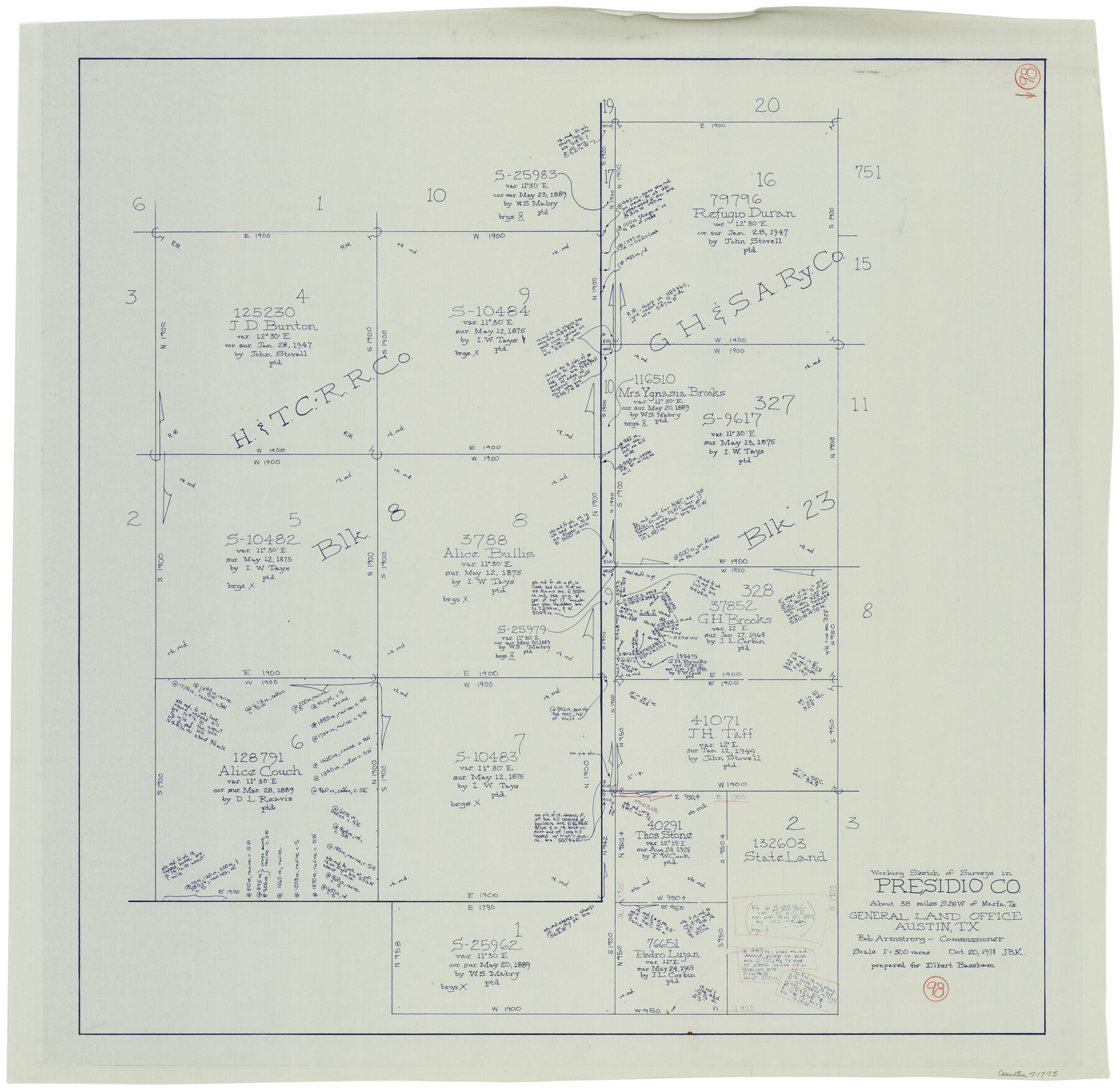
Presidio County Working Sketch 98
-
Map/Doc
71775
-
Collection
General Map Collection
-
Object Dates
10/20/1978 (Creation Date)
-
People and Organizations
Joan Kilpatrick (Draftsman)
-
Counties
Presidio
-
Subjects
Surveying Working Sketch
-
Height x Width
30.9 x 31.7 inches
78.5 x 80.5 cm
-
Scale
1" = 300 varas
Part of: General Map Collection
Hansford County Boundary File 2a

Print $40.00
- Digital $50.00
Hansford County Boundary File 2a
Size 14.2 x 8.7 inches
Map/Doc 54252
Goliad County Sketch File 23

Print $4.00
- Digital $50.00
Goliad County Sketch File 23
1877
Size 8.1 x 12.8 inches
Map/Doc 24295
Cass County Sketch File 3

Print $4.00
- Digital $50.00
Cass County Sketch File 3
Size 12.8 x 8.5 inches
Map/Doc 17396
Atascosa County Boundary File 6

Print $34.00
- Digital $50.00
Atascosa County Boundary File 6
Size 9.1 x 23.0 inches
Map/Doc 50205
Northwest Part Crockett County

Print $40.00
- Digital $50.00
Northwest Part Crockett County
1983
Size 37.3 x 48.3 inches
Map/Doc 95470
Flight Mission No. DAG-26K, Frame 60, Matagorda County

Print $20.00
- Digital $50.00
Flight Mission No. DAG-26K, Frame 60, Matagorda County
1953
Size 18.7 x 22.7 inches
Map/Doc 86580
Coryell County Working Sketch 2

Print $20.00
- Digital $50.00
Coryell County Working Sketch 2
1906
Size 15.3 x 18.5 inches
Map/Doc 68209
Right of Way and Track Map of The Wichita Falls & Southern Railroad Company

Print $40.00
- Digital $50.00
Right of Way and Track Map of The Wichita Falls & Southern Railroad Company
1942
Size 24.6 x 56.1 inches
Map/Doc 64519
Val Verde Co.

Print $20.00
- Digital $50.00
Val Verde Co.
1908
Size 39.1 x 37.7 inches
Map/Doc 63102
Old Miscellaneous File 4

Print $22.00
- Digital $50.00
Old Miscellaneous File 4
1845
Size 16.5 x 20.8 inches
Map/Doc 75416
Val Verde County Working Sketch 8

Print $20.00
- Digital $50.00
Val Verde County Working Sketch 8
1917
Size 31.4 x 32.0 inches
Map/Doc 72143
Victoria County Sketch File 2

Print $7.00
- Digital $50.00
Victoria County Sketch File 2
1873
Size 10.3 x 8.4 inches
Map/Doc 39511
You may also like
Gaines County Rolled Sketch 15A

Print $40.00
- Digital $50.00
Gaines County Rolled Sketch 15A
Size 90.5 x 23.8 inches
Map/Doc 9036
Presidio County Rolled Sketch 131A

Print $3.00
- Digital $50.00
Presidio County Rolled Sketch 131A
Size 15.8 x 9.3 inches
Map/Doc 10708
Aransas County NRC Article 33.136 Sketch 12

Print $44.00
- Digital $50.00
Aransas County NRC Article 33.136 Sketch 12
2012
Size 36.0 x 48.0 inches
Map/Doc 94510
Wilbarger County Sketch File 9

Print $4.00
- Digital $50.00
Wilbarger County Sketch File 9
1885
Size 12.7 x 8.2 inches
Map/Doc 40181
Matagorda Bay and Approaches

Print $20.00
- Digital $50.00
Matagorda Bay and Approaches
1961
Size 35.0 x 45.0 inches
Map/Doc 73382
Kaufman County Working Sketch 8

Print $20.00
- Digital $50.00
Kaufman County Working Sketch 8
1987
Size 35.7 x 42.3 inches
Map/Doc 66671
Parker County Working Sketch 22

Print $20.00
- Digital $50.00
Parker County Working Sketch 22
2007
Map/Doc 88607
Kimble County Sketch File 6

Print $4.00
- Digital $50.00
Kimble County Sketch File 6
Size 6.4 x 8.0 inches
Map/Doc 28918
Sketch Showing Division Fence Shelton- Matador, Oldham County

Print $20.00
- Digital $50.00
Sketch Showing Division Fence Shelton- Matador, Oldham County
Size 21.6 x 24.4 inches
Map/Doc 91484
Gray County Working Sketch 2

Print $20.00
- Digital $50.00
Gray County Working Sketch 2
1957
Size 26.7 x 27.8 inches
Map/Doc 63233
Wilbarger County Sketch File 29

Print $18.00
- Digital $50.00
Wilbarger County Sketch File 29
2016
Size 11.0 x 8.5 inches
Map/Doc 95325
Flight Mission No. DCL-4C, Frame 4, Kenedy County

Print $20.00
- Digital $50.00
Flight Mission No. DCL-4C, Frame 4, Kenedy County
1943
Size 18.7 x 22.3 inches
Map/Doc 85805