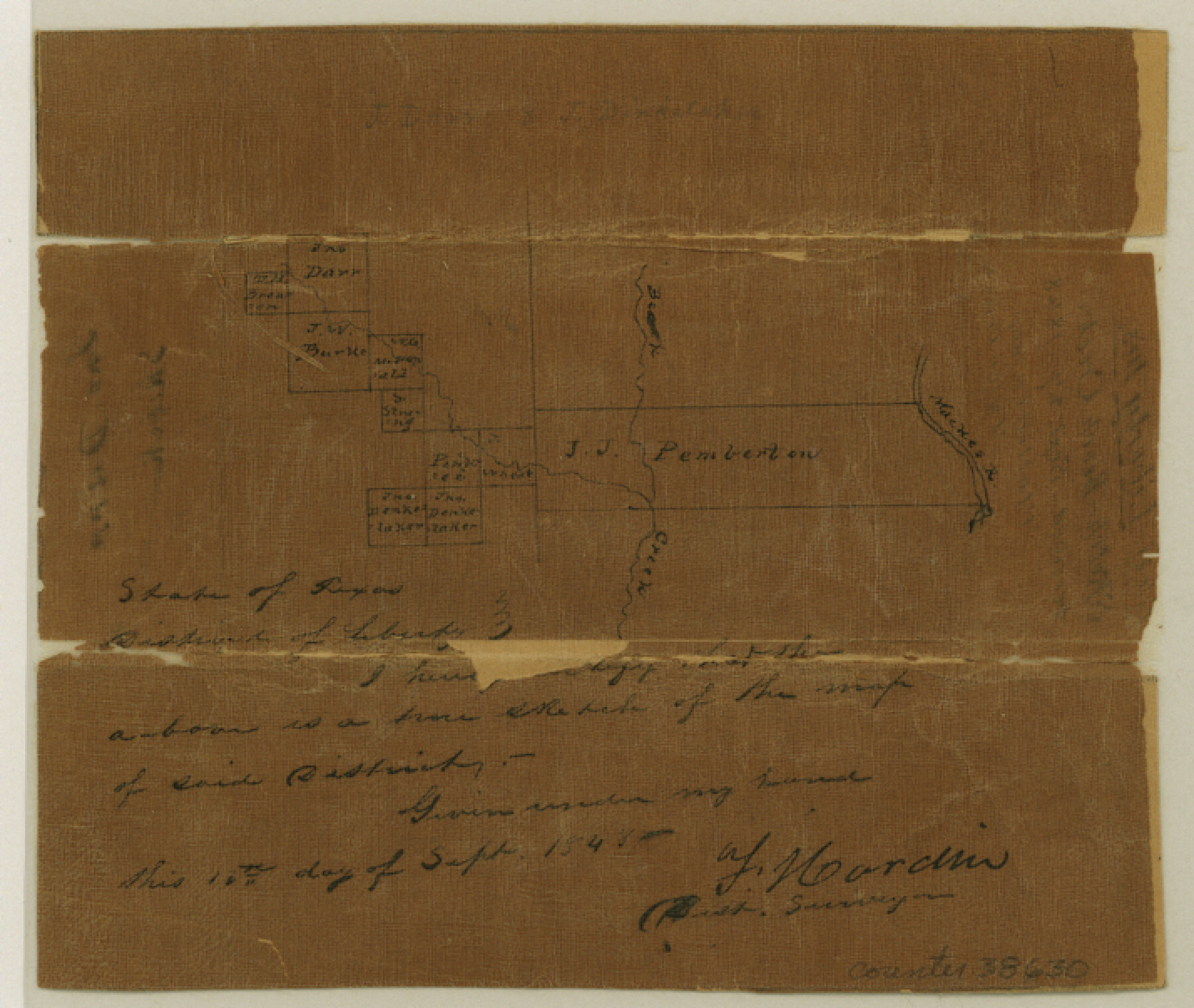
Tyler County Sketch File 6
[Sketch of surveys around Beech Creek and the Pemberton survey on the Neches River in the east part of the county]
-
Map/Doc
38630
-
Collection
General Map Collection
-
Object Dates
9/12/1848 (Creation Date)
9/27/1848 (File Date)
-
People and Organizations
F. Hardin (Surveyor/Engineer)
-
Counties
Tyler
-
Subjects
Surveying Sketch File
-
Height x Width
6.0 x 7.1 inches
15.2 x 18.0 cm
-
Medium
paper, manuscript
-
Features
Beech Creek
Naches [sic] River
Part of: General Map Collection
Kendall County Sketch File 13

Print $4.00
- Digital $50.00
Kendall County Sketch File 13
1860
Size 10.1 x 8.0 inches
Map/Doc 28699

Controlled Mosaic by Jack Amman Photogrammetric Engineers, Inc - Sheet 40

Print $20.00
- Digital $50.00
Controlled Mosaic by Jack Amman Photogrammetric Engineers, Inc - Sheet 40
1954
Size 20.0 x 24.0 inches
Map/Doc 83495
Concho County Sketch File 16

Print $20.00
- Digital $50.00
Concho County Sketch File 16
Size 8.2 x 18.6 inches
Map/Doc 11151
Intracoastal Waterway in Texas - Corpus Christi to Point Isabel including Arroyo Colorado to Mo. Pac. R.R. Bridge Near Harlingen

Print $20.00
- Digital $50.00
Intracoastal Waterway in Texas - Corpus Christi to Point Isabel including Arroyo Colorado to Mo. Pac. R.R. Bridge Near Harlingen
1933
Size 28.1 x 41.0 inches
Map/Doc 61844
Kinney County Working Sketch Graphic Index

Print $40.00
- Digital $50.00
Kinney County Working Sketch Graphic Index
1955
Size 48.6 x 42.5 inches
Map/Doc 76609
Nueces County Rolled Sketch 60

Print $40.00
- Digital $50.00
Nueces County Rolled Sketch 60
Size 95.5 x 32.3 inches
Map/Doc 9607
Howard County Rolled Sketch 11

Print $20.00
- Digital $50.00
Howard County Rolled Sketch 11
1940
Size 21.4 x 30.1 inches
Map/Doc 6242
Montague County Sketch File 19

Print $6.00
- Digital $50.00
Montague County Sketch File 19
1924
Size 11.2 x 8.5 inches
Map/Doc 31748
Trinity River, Post Oak Creek Sheet

Print $4.00
- Digital $50.00
Trinity River, Post Oak Creek Sheet
1930
Size 20.6 x 23.0 inches
Map/Doc 65227
[Surveys along Neils and Turkey Creeks]
![69761, [Surveys along Neils and Turkey Creeks], General Map Collection](https://historictexasmaps.com/wmedia_w700/maps/69761.tif.jpg)
Print $2.00
- Digital $50.00
[Surveys along Neils and Turkey Creeks]
1846
Size 10.8 x 7.9 inches
Map/Doc 69761
Lubbock County

Print $20.00
- Digital $50.00
Lubbock County
1892
Size 20.1 x 19.3 inches
Map/Doc 3828
You may also like
Flight Mission No. CRE-1R, Frame 65, Jackson County

Print $20.00
- Digital $50.00
Flight Mission No. CRE-1R, Frame 65, Jackson County
1956
Size 18.6 x 22.3 inches
Map/Doc 85328
Tom Green County Sketch File 75

Print $20.00
- Digital $50.00
Tom Green County Sketch File 75
1950
Size 18.1 x 22.5 inches
Map/Doc 12449
Crosby County Boundary File 3

Print $2.00
- Digital $50.00
Crosby County Boundary File 3
Size 11.2 x 8.7 inches
Map/Doc 52002
Harrison County Sketch File 17

Print $4.00
- Digital $50.00
Harrison County Sketch File 17
1874
Size 8.8 x 10.5 inches
Map/Doc 26059
Township No. 5 South, Range No. 14 West, Indian Meridian, Oklahoma

Print $4.00
- Digital $50.00
Township No. 5 South, Range No. 14 West, Indian Meridian, Oklahoma
1928
Size 18.0 x 22.6 inches
Map/Doc 75141
Flight Mission No. CRC-3R, Frame 104, Chambers County

Print $20.00
- Digital $50.00
Flight Mission No. CRC-3R, Frame 104, Chambers County
1956
Size 18.6 x 22.3 inches
Map/Doc 84842
Mississippi River to Galveston

Print $40.00
- Digital $50.00
Mississippi River to Galveston
1973
Size 37.2 x 51.2 inches
Map/Doc 69946
Andrews County Boundary File 2c

Print $70.00
- Digital $50.00
Andrews County Boundary File 2c
Size 14.6 x 9.2 inches
Map/Doc 49709
Flight Mission No. CUG-3P, Frame 134, Kleberg County

Print $20.00
- Digital $50.00
Flight Mission No. CUG-3P, Frame 134, Kleberg County
1956
Size 18.5 x 22.3 inches
Map/Doc 86269
Jasper County Sketch File 34

Print $4.00
- Digital $50.00
Jasper County Sketch File 34
1873
Size 12.4 x 8.1 inches
Map/Doc 27868

Reeves County Working Sketch 43

Print $20.00
- Digital $50.00
Reeves County Working Sketch 43
1974
Size 43.2 x 37.1 inches
Map/Doc 63486