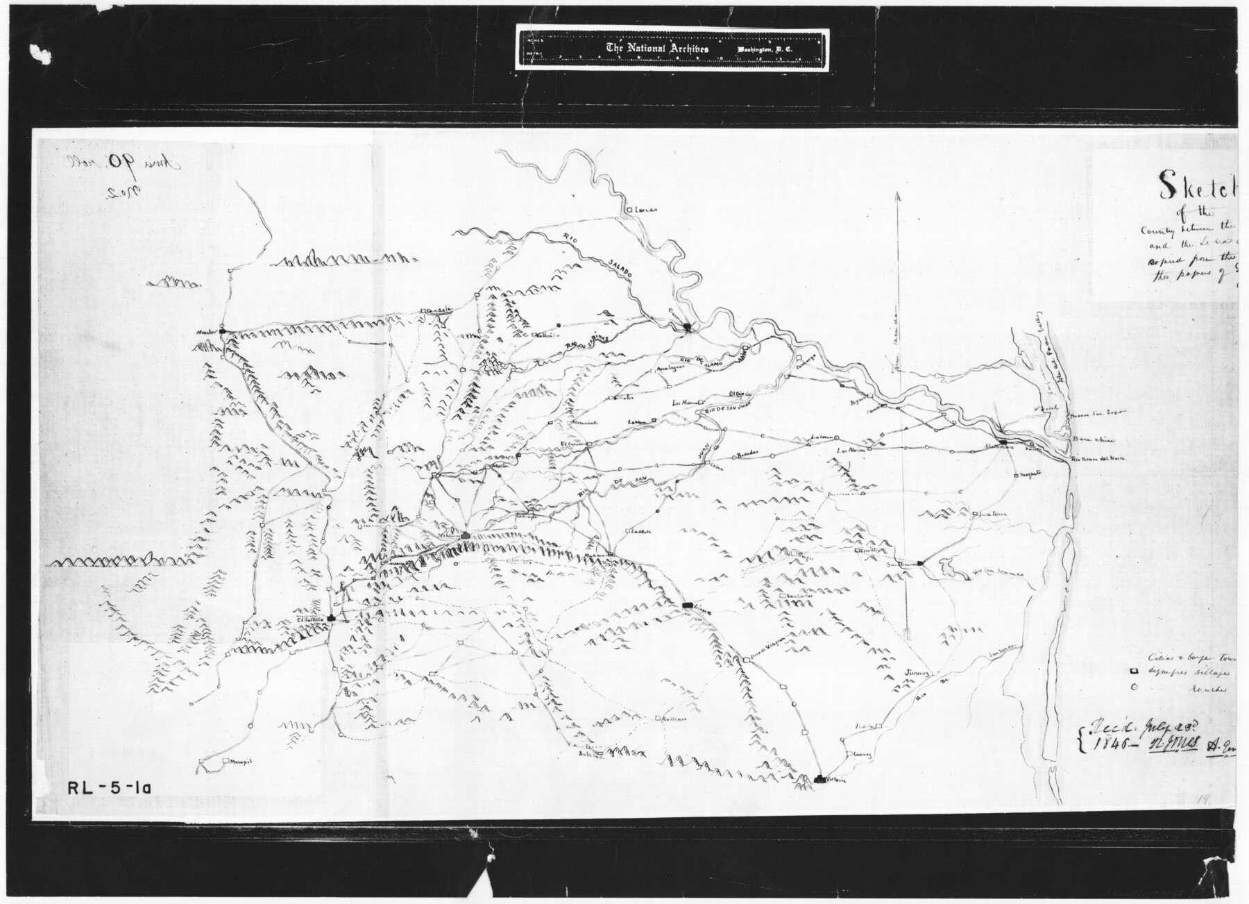
Sketch of the country between the Rio Bravo del Norte and the Luna Madre as high as Monterey copied from the map found among the papers of Genl. Arista
RL-5-1a
-
Map/Doc
73048
-
Collection
General Map Collection
-
Object Dates
1846 (Creation Date)
-
People and Organizations
George G. Meade (Draftsman)
-
Subjects
Military
-
Height x Width
18.2 x 25.1 inches
46.2 x 63.8 cm
-
Comments
B/W photostat copy from National Archives in multiple pieces.
Part of: General Map Collection
Flight Mission No. CGI-3N, Frame 72, Cameron County

Print $20.00
- Digital $50.00
Flight Mission No. CGI-3N, Frame 72, Cameron County
1954
Size 18.5 x 22.3 inches
Map/Doc 84566
Mitchell County Working Sketch 2

Print $20.00
- Digital $50.00
Mitchell County Working Sketch 2
1922
Size 14.8 x 18.1 inches
Map/Doc 71059
Briscoe County Rolled Sketch 14

Print $40.00
- Digital $50.00
Briscoe County Rolled Sketch 14
1913
Size 36.0 x 48.9 inches
Map/Doc 8529
Culberson County Working Sketch 15

Print $20.00
- Digital $50.00
Culberson County Working Sketch 15
1923
Size 19.9 x 21.5 inches
Map/Doc 68467
Jim Hogg County Sketch File 4

Print $8.00
- Digital $50.00
Jim Hogg County Sketch File 4
1926
Size 11.2 x 8.7 inches
Map/Doc 28404
Right of Way and Track Map Houston & Texas Central R.R. operated by the T. and N. O. R.R. Co., Fort Worth Branch

Print $40.00
- Digital $50.00
Right of Way and Track Map Houston & Texas Central R.R. operated by the T. and N. O. R.R. Co., Fort Worth Branch
1918
Size 30.9 x 57.1 inches
Map/Doc 64541
Johnson County Boundary File 2

Print $56.00
- Digital $50.00
Johnson County Boundary File 2
Size 9.5 x 34.9 inches
Map/Doc 55556
Williamson County Sketch File 15

Print $4.00
- Digital $50.00
Williamson County Sketch File 15
Size 10.0 x 8.0 inches
Map/Doc 40334
Map of Orange County

Print $20.00
- Digital $50.00
Map of Orange County
1895
Size 15.5 x 16.2 inches
Map/Doc 3932
Duval County Working Sketch 25

Print $20.00
- Digital $50.00
Duval County Working Sketch 25
1946
Size 23.7 x 20.1 inches
Map/Doc 68749
Fractional Township No. 8 South Range No. 3 West of the indian Meridian, Indian Territory

Print $20.00
- Digital $50.00
Fractional Township No. 8 South Range No. 3 West of the indian Meridian, Indian Territory
1898
Size 19.4 x 24.4 inches
Map/Doc 75194
Cameron County Rolled Sketch Z1

Print $20.00
- Digital $50.00
Cameron County Rolled Sketch Z1
1937
Size 23.4 x 41.4 inches
Map/Doc 5401
You may also like
South Part Presidio County

Print $20.00
- Digital $50.00
South Part Presidio County
1975
Size 35.0 x 40.3 inches
Map/Doc 95617
Old Miscellaneous File 12

Print $14.00
- Digital $50.00
Old Miscellaneous File 12
1899
Size 14.2 x 8.6 inches
Map/Doc 75439
The Judicial District/County of Menard. Abolished, Spring 1842

Print $20.00
The Judicial District/County of Menard. Abolished, Spring 1842
2020
Size 22.4 x 21.7 inches
Map/Doc 96337
Cass County Working Sketch 5

Print $20.00
- Digital $50.00
Cass County Working Sketch 5
1936
Size 45.6 x 43.1 inches
Map/Doc 67908
Somervell County

Print $20.00
- Digital $50.00
Somervell County
1941
Size 29.2 x 27.1 inches
Map/Doc 95642
Uvalde County Sketch File 20a

Print $20.00
- Digital $50.00
Uvalde County Sketch File 20a
1911
Size 22.7 x 23.8 inches
Map/Doc 12532
Flight Mission No. DCL-7C, Frame 56, Kenedy County

Print $20.00
- Digital $50.00
Flight Mission No. DCL-7C, Frame 56, Kenedy County
1943
Size 15.4 x 15.2 inches
Map/Doc 86044
Nacogdoches County Sketch File 19

Print $12.00
- Digital $50.00
Nacogdoches County Sketch File 19
1846
Size 17.0 x 11.0 inches
Map/Doc 32270
Taylor County Sketch File 4

Print $2.00
- Digital $50.00
Taylor County Sketch File 4
Size 7.2 x 9.8 inches
Map/Doc 37780
Reeves County Sketch File 26

Print $4.00
- Digital $50.00
Reeves County Sketch File 26
1964
Size 4.1 x 8.8 inches
Map/Doc 35226

Flight Mission No. CLL-3N, Frame 40, Willacy County

Print $20.00
- Digital $50.00
Flight Mission No. CLL-3N, Frame 40, Willacy County
1954
Size 18.3 x 22.0 inches
Map/Doc 87098