Harris County Rolled Sketch 88
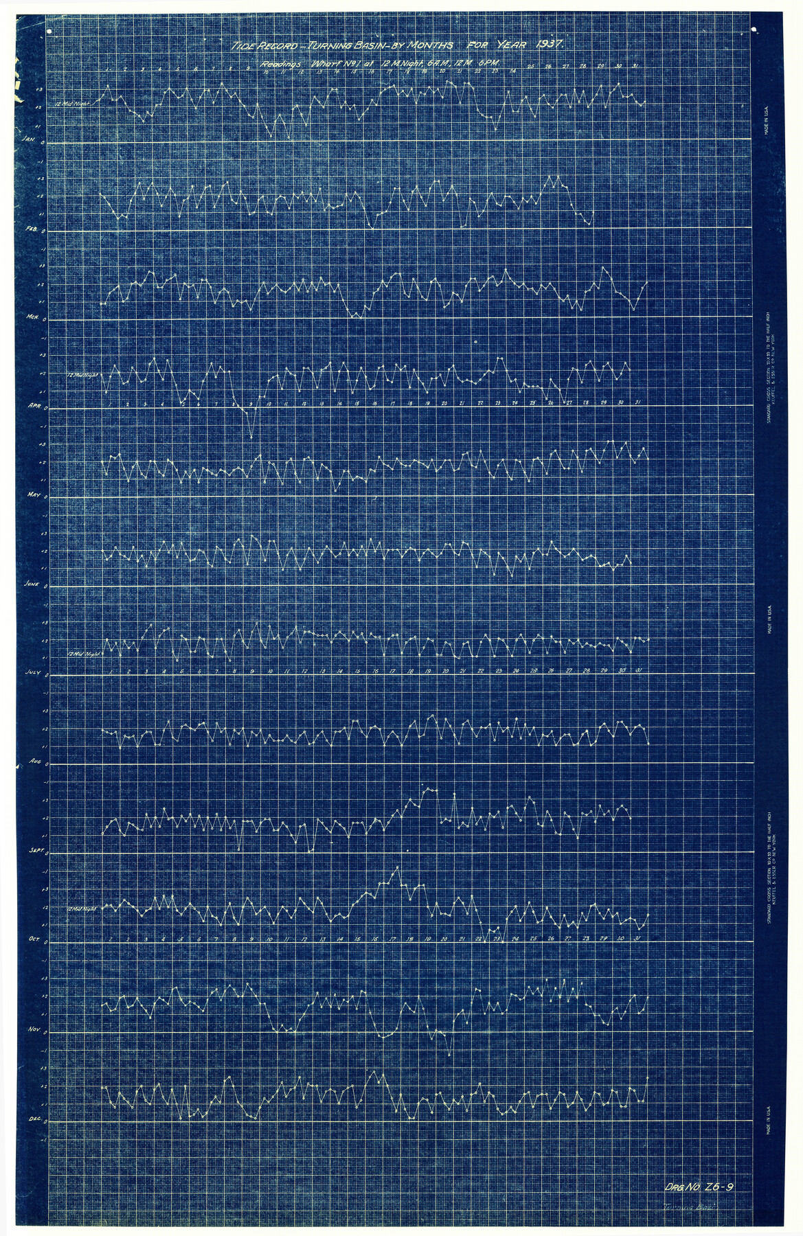
Tide Record - Turning Basin - by months for year 1937 - Readings - Wharf No. 1 at 12 M Night, 6 A.M., 12 M., - 6 P.M.
-
Map/Doc
6126
-
Collection
General Map Collection
-
Object Dates
1937 (Creation Date)
-
Counties
Harris
-
Subjects
Surveying Rolled Sketch
-
Height x Width
34.9 x 22.7 inches
88.7 x 57.7 cm
-
Medium
blueprint/diazo
Part of: General Map Collection
Nueces County Sketch File 31

Print $8.00
- Digital $50.00
Nueces County Sketch File 31
1907
Size 14.1 x 8.6 inches
Map/Doc 32601
Flight Mission No. BQY-4M, Frame 41, Harris County

Print $20.00
- Digital $50.00
Flight Mission No. BQY-4M, Frame 41, Harris County
1953
Size 18.6 x 22.4 inches
Map/Doc 85256
Hardeman County Aerial Photograph Index Sheet 2

Print $20.00
- Digital $50.00
Hardeman County Aerial Photograph Index Sheet 2
1950
Size 20.3 x 16.9 inches
Map/Doc 83698
Bandera County Working Sketch 29

Print $20.00
- Digital $50.00
Bandera County Working Sketch 29
1954
Size 19.6 x 19.3 inches
Map/Doc 67625
Waller County Sketch File 12

Print $6.00
- Digital $50.00
Waller County Sketch File 12
1928
Size 7.6 x 8.8 inches
Map/Doc 39616
Tom Green County Sketch File 55 1/2

Print $20.00
- Digital $50.00
Tom Green County Sketch File 55 1/2
1886
Size 26.4 x 13.6 inches
Map/Doc 12443
United States - Gulf Coast Texas - Southern part of Laguna Madre

Print $20.00
- Digital $50.00
United States - Gulf Coast Texas - Southern part of Laguna Madre
1941
Size 18.2 x 27.7 inches
Map/Doc 72947
"The Texas and Pacific Railway Company Reservation and Land Grant"

Print $38.00
- Digital $50.00
"The Texas and Pacific Railway Company Reservation and Land Grant"
1962
Size 9.3 x 6.5 inches
Map/Doc 62213
Cameron County Sketch File 14

Print $38.00
- Digital $50.00
Cameron County Sketch File 14
1993
Size 11.2 x 8.8 inches
Map/Doc 17311
Waller County Sketch File 1a

Print $20.00
- Digital $50.00
Waller County Sketch File 1a
Size 25.4 x 16.6 inches
Map/Doc 12598
Red River County Sketch File 10

Print $15.00
- Digital $50.00
Red River County Sketch File 10
1863
Size 9.1 x 7.4 inches
Map/Doc 35121
San Augustine County Working Sketch 24

Print $20.00
- Digital $50.00
San Augustine County Working Sketch 24
1975
Size 27.8 x 39.1 inches
Map/Doc 63712
You may also like
Haskell County Working Sketch 11

Print $20.00
- Digital $50.00
Haskell County Working Sketch 11
1976
Size 38.0 x 33.4 inches
Map/Doc 66069
North Sulphur River, Ben Franklin Sheet

Print $40.00
- Digital $50.00
North Sulphur River, Ben Franklin Sheet
1928
Size 24.6 x 57.4 inches
Map/Doc 65172
[John Durst's grant along the Trinity River]
![185, [John Durst's grant along the Trinity River], General Map Collection](https://historictexasmaps.com/wmedia_w700/maps/185.tif.jpg)
Print $2.00
- Digital $50.00
[John Durst's grant along the Trinity River]
Size 12.3 x 8.2 inches
Map/Doc 185
Brazoria County Sketch File 5

Print $4.00
- Digital $50.00
Brazoria County Sketch File 5
1862
Size 13.1 x 8.1 inches
Map/Doc 14929
El Nuevo Mexico y Tierras Adyacentes Mapa Levantado para la demarcacion de los Limites de los Dominios Españoles y de los Estados Unidos

El Nuevo Mexico y Tierras Adyacentes Mapa Levantado para la demarcacion de los Limites de los Dominios Españoles y de los Estados Unidos
1811
Size 27.9 x 36.6 inches
Map/Doc 97483
Flight Mission No. DAG-26K, Frame 83, Matagorda County

Print $20.00
- Digital $50.00
Flight Mission No. DAG-26K, Frame 83, Matagorda County
1953
Size 18.6 x 19.6 inches
Map/Doc 86588

S.B. Burnett's King County Ranch

Print $20.00
- Digital $50.00
S.B. Burnett's King County Ranch
1902
Size 32.3 x 30.6 inches
Map/Doc 4441
Childress County Sketch File 15

Print $8.00
- Digital $50.00
Childress County Sketch File 15
Size 14.3 x 8.3 inches
Map/Doc 18278
Flight Mission No. BRE-2P, Frame 65, Nueces County

Print $20.00
- Digital $50.00
Flight Mission No. BRE-2P, Frame 65, Nueces County
1956
Size 18.4 x 22.3 inches
Map/Doc 86760
Crockett County Rolled Sketch 66

Print $20.00
- Digital $50.00
Crockett County Rolled Sketch 66
1947
Size 22.4 x 23.3 inches
Map/Doc 5609
The Republic County of Nacogdoches. December 29, 1845

Print $20.00
The Republic County of Nacogdoches. December 29, 1845
2020
Size 15.9 x 21.8 inches
Map/Doc 96250