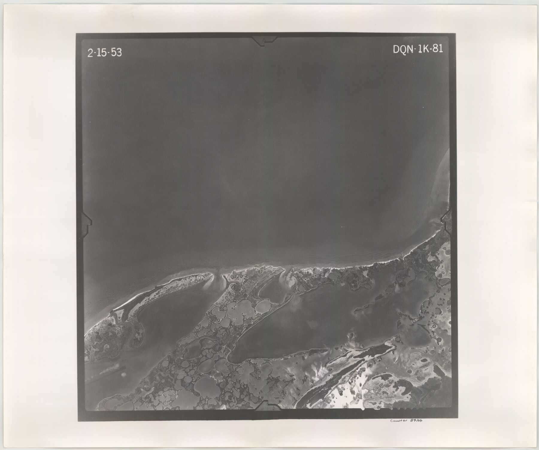
Flight Mission No. DQN-1K, Frame 81, Calhoun County
DQN-1K-81
-
Map/Doc
84166
-
Collection
General Map Collection
-
Object Dates
1953/2/15 (Creation Date)
-
People and Organizations
U. S. Department of Agriculture (Publisher)
-
Counties
Calhoun
-
Subjects
Aerial Photograph
-
Height x Width
18.4 x 22.1 inches
46.7 x 56.1 cm
-
Comments
Flown by Aero Exploration Company of Tulsa, Oklahoma.
Part of: General Map Collection
Sketch of State University Lands and Connections in El Paso Co.

Print $20.00
- Digital $50.00
Sketch of State University Lands and Connections in El Paso Co.
1900
Size 33.1 x 32.4 inches
Map/Doc 2427
Wharton County Working Sketch 16

Print $20.00
- Digital $50.00
Wharton County Working Sketch 16
1952
Size 23.8 x 26.8 inches
Map/Doc 72480
Henderson County Rolled Sketch 11

Print $20.00
- Digital $50.00
Henderson County Rolled Sketch 11
1915
Size 29.4 x 42.2 inches
Map/Doc 75949
Map of Ramsey State Farm

Print $20.00
- Digital $50.00
Map of Ramsey State Farm
1934
Size 30.3 x 38.0 inches
Map/Doc 94284
El Paso County Rolled Sketch 52

Print $20.00
- Digital $50.00
El Paso County Rolled Sketch 52
1929
Size 18.5 x 24.4 inches
Map/Doc 5838
No. 3 Chart of Channel connecting Corpus Christi Bay with Aransas Bay, Texas

Print $20.00
- Digital $50.00
No. 3 Chart of Channel connecting Corpus Christi Bay with Aransas Bay, Texas
1878
Size 27.8 x 18.2 inches
Map/Doc 72778
Brazoria County Rolled Sketch 19

Print $20.00
- Digital $50.00
Brazoria County Rolled Sketch 19
Size 16.9 x 19.0 inches
Map/Doc 5166
Galveston Harbor, Texas - U.S. Harbor Lines - Galveston Harbor, Galveston Channel, Channel from Galveston Harbor to Texas City and Channel to Port Bolivar

Print $20.00
- Digital $50.00
Galveston Harbor, Texas - U.S. Harbor Lines - Galveston Harbor, Galveston Channel, Channel from Galveston Harbor to Texas City and Channel to Port Bolivar
1939
Size 39.4 x 26.7 inches
Map/Doc 73631
Upton County Working Sketch 18

Print $20.00
- Digital $50.00
Upton County Working Sketch 18
1945
Size 19.7 x 19.9 inches
Map/Doc 69514
Webb County Working Sketch 97

Print $20.00
- Digital $50.00
Webb County Working Sketch 97
1994
Size 27.1 x 30.6 inches
Map/Doc 72464
[St. Louis & Southwestern]
![64275, [St. Louis & Southwestern], General Map Collection](https://historictexasmaps.com/wmedia_w700/maps/64275.tif.jpg)
Print $20.00
- Digital $50.00
[St. Louis & Southwestern]
Size 20.8 x 28.6 inches
Map/Doc 64275
Wilbarger Co.

Print $20.00
- Digital $50.00
Wilbarger Co.
1949
Size 46.8 x 38.1 inches
Map/Doc 77458
You may also like
Jefferson County NRC Article 33.136 Sketch 1

Print $20.00
- Digital $50.00
Jefferson County NRC Article 33.136 Sketch 1
2002
Size 24.0 x 36.1 inches
Map/Doc 61601
Jeff Davis County Rolled Sketch 22

Print $399.00
- Digital $50.00
Jeff Davis County Rolled Sketch 22
Size 17.2 x 15.8 inches
Map/Doc 6487
Houston County Sketch File 31

Print $2.00
- Digital $50.00
Houston County Sketch File 31
1888
Size 9.1 x 7.9 inches
Map/Doc 26808
[Blocks W and Z with tie lines]
![90451, [Blocks W and Z with tie lines], Twichell Survey Records](https://historictexasmaps.com/wmedia_w700/maps/90451-1.tif.jpg)
Print $20.00
- Digital $50.00
[Blocks W and Z with tie lines]
1949
Size 14.4 x 14.2 inches
Map/Doc 90451
Kleberg County Rolled Sketch 10-3

Print $20.00
- Digital $50.00
Kleberg County Rolled Sketch 10-3
1951
Size 37.5 x 32.0 inches
Map/Doc 9388
Red River County Rolled Sketch 2

Print $20.00
- Digital $50.00
Red River County Rolled Sketch 2
Size 33.3 x 28.4 inches
Map/Doc 7471
Reeves County Boundary File 73a

Print $16.00
- Digital $50.00
Reeves County Boundary File 73a
Size 13.3 x 8.2 inches
Map/Doc 58208
Dawson County Sketch File 20

Print $20.00
- Digital $50.00
Dawson County Sketch File 20
1951
Size 13.2 x 21.5 inches
Map/Doc 11296
Angelina County Sketch File 22

Print $8.00
- Digital $50.00
Angelina County Sketch File 22
1891
Size 14.0 x 8.7 inches
Map/Doc 13049

Pecos County Working Sketch 100

Print $20.00
- Digital $50.00
Pecos County Working Sketch 100
1970
Size 42.9 x 31.6 inches
Map/Doc 71573
Maps of Gulf Intracoastal Waterway, Texas - Sabine River to the Rio Grande and connecting waterways including ship channels

Print $20.00
- Digital $50.00
Maps of Gulf Intracoastal Waterway, Texas - Sabine River to the Rio Grande and connecting waterways including ship channels
1966
Size 14.5 x 20.8 inches
Map/Doc 61968