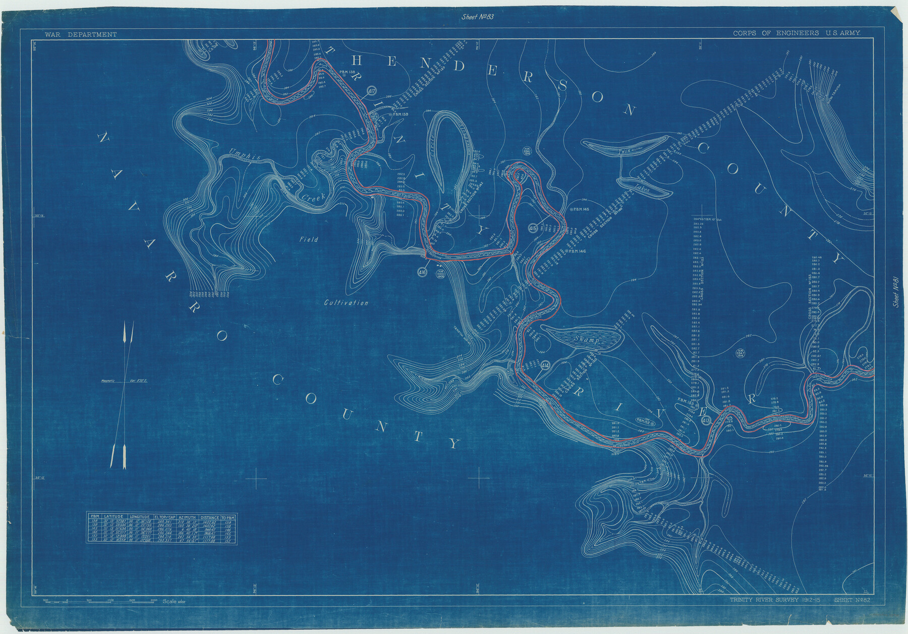
Henderson County Rolled Sketch 11
Trinity River Survey 1912-15, Sheet No. 82
N-1-45
-
Map/Doc
75949
-
Collection
General Map Collection
-
Object Dates
1915 (Creation Date)
1976/2/13 (File Date)
-
People and Organizations
War Department (Publisher)
-
Counties
Henderson Navarro
-
Subjects
River Surveys Surveying Rolled Sketch
-
Height x Width
29.4 x 42.2 inches
74.7 x 107.2 cm
-
Medium
blueprint/diazo
Part of: General Map Collection
Tyler County Sketch File 20

Print $6.00
- Digital $50.00
Tyler County Sketch File 20
1851
Size 6.9 x 5.8 inches
Map/Doc 38674
Garza County Sketch File E1

Print $8.00
- Digital $50.00
Garza County Sketch File E1
1901
Size 11.2 x 8.8 inches
Map/Doc 24022
Henderson County Working Sketch 17

Print $20.00
- Digital $50.00
Henderson County Working Sketch 17
1937
Size 27.3 x 27.4 inches
Map/Doc 66150
[Surveys along the San Antonio Road near Caldwell]
![69760, [Surveys along the San Antonio Road near Caldwell], General Map Collection](https://historictexasmaps.com/wmedia_w700/maps/69760.tif.jpg)
Print $2.00
- Digital $50.00
[Surveys along the San Antonio Road near Caldwell]
1846
Size 9.2 x 7.7 inches
Map/Doc 69760
San Jacinto County Rolled Sketch 10B

Print $40.00
- Digital $50.00
San Jacinto County Rolled Sketch 10B
1944
Size 76.5 x 43.2 inches
Map/Doc 9883
Nautical Chart 885-SC Intracoastal Waterway - Ellender to Galveston Bay, Louisiana-Texas

Print $20.00
- Digital $50.00
Nautical Chart 885-SC Intracoastal Waterway - Ellender to Galveston Bay, Louisiana-Texas
1972
Size 15.9 x 26.8 inches
Map/Doc 75910
[Map of Zapata County]
![4178, [Map of Zapata County], General Map Collection](https://historictexasmaps.com/wmedia_w700/maps/4178.tif.jpg)
Print $20.00
- Digital $50.00
[Map of Zapata County]
1883
Size 20.5 x 20.9 inches
Map/Doc 4178
Armstrong County Sketch File A-15

Print $40.00
- Digital $50.00
Armstrong County Sketch File A-15
Size 17.8 x 14.0 inches
Map/Doc 13716
The North Coast of the Gulf of Mexico from St. Marks to Galveston

Print $20.00
- Digital $50.00
The North Coast of the Gulf of Mexico from St. Marks to Galveston
1844
Size 27.5 x 41.1 inches
Map/Doc 97396
Zapata County Rolled Sketch 7A

Print $20.00
- Digital $50.00
Zapata County Rolled Sketch 7A
1912
Size 17.9 x 26.6 inches
Map/Doc 8309
Jeff Davis County Sketch File 34

Print $16.00
- Digital $50.00
Jeff Davis County Sketch File 34
1915
Size 8.5 x 5.4 inches
Map/Doc 28040
Liberty County Sketch File 16

Print $4.00
- Digital $50.00
Liberty County Sketch File 16
1859
Size 11.4 x 6.7 inches
Map/Doc 29917
You may also like
Ochiltree County Boundary File 4

Print $4.00
- Digital $50.00
Ochiltree County Boundary File 4
Size 11.1 x 8.7 inches
Map/Doc 57682
La Salle County Sketch File 28

Print $6.00
- Digital $50.00
La Salle County Sketch File 28
1882
Size 8.7 x 3.6 inches
Map/Doc 29555
Hood County Sketch File 12

Print $35.00
- Digital $50.00
Hood County Sketch File 12
Size 9.0 x 9.7 inches
Map/Doc 26590
Brewster County Sketch File 18

Print $8.00
- Digital $50.00
Brewster County Sketch File 18
1942
Size 13.8 x 7.6 inches
Map/Doc 15813
Howard County Boundary File 2a

Print $9.00
- Digital $50.00
Howard County Boundary File 2a
Size 14.6 x 11.3 inches
Map/Doc 55118
Preliminary Chart No. 31 of the Sea Coast of the United States from Galveston Bay to Matagorda Bay, Texas

Print $20.00
- Digital $50.00
Preliminary Chart No. 31 of the Sea Coast of the United States from Galveston Bay to Matagorda Bay, Texas
1857
Size 23.3 x 28.1 inches
Map/Doc 69950
Hudspeth County Working Sketch 32a

Print $40.00
- Digital $50.00
Hudspeth County Working Sketch 32a
1975
Size 57.4 x 39.3 inches
Map/Doc 66317
Roberts County Working Sketch 14

Print $20.00
- Digital $50.00
Roberts County Working Sketch 14
1975
Size 23.1 x 24.6 inches
Map/Doc 63540
Evans Addition to Ropes Hockley County, Texas Situated on W. L. Ellwood's Subdivision Number 19 League 9, Donley County School Land

Print $20.00
- Digital $50.00
Evans Addition to Ropes Hockley County, Texas Situated on W. L. Ellwood's Subdivision Number 19 League 9, Donley County School Land
1923
Size 24.2 x 21.0 inches
Map/Doc 92259
Hudspeth County Sketch File 11

Print $14.00
- Digital $50.00
Hudspeth County Sketch File 11
Size 14.5 x 8.9 inches
Map/Doc 26903
[Sutton, Hale & Ector Co. School Land]
![90102, [Sutton, Hale & Ector Co. School Land], Twichell Survey Records](https://historictexasmaps.com/wmedia_w700/maps/90102-1.tif.jpg)
Print $3.00
- Digital $50.00
[Sutton, Hale & Ector Co. School Land]
Size 9.7 x 16.8 inches
Map/Doc 90102
Jeff Davis County Working Sketch 35

Print $20.00
- Digital $50.00
Jeff Davis County Working Sketch 35
1979
Size 34.4 x 36.9 inches
Map/Doc 66530