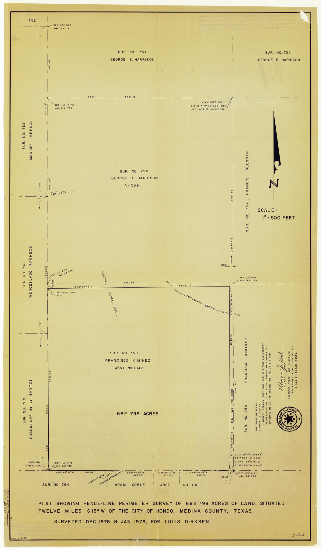
Medina County Rolled Sketch 17
Plat showing fence-line perimeter survey of 662.799 acres of land
-
Map/Doc
6750
-
Collection
General Map Collection
-
Object Dates
1/1979 (Creation Date)
11/1982 (File Date)
-
People and Organizations
Hilmar J. Koch (Surveyor/Engineer)
-
Counties
Medina
-
Subjects
Surveying Rolled Sketch
-
Height x Width
32.3 x 18.9 inches
82.0 x 48.0 cm
-
Medium
van dyke/brownline/sepia
-
Scale
1" = 500 feet
Part of: General Map Collection
Hardin County Sketch File 3

Print $4.00
- Digital $50.00
Hardin County Sketch File 3
Size 7.7 x 4.6 inches
Map/Doc 25086
Edwards County Rolled Sketch 17

Print $20.00
- Digital $50.00
Edwards County Rolled Sketch 17
1945
Size 27.6 x 19.4 inches
Map/Doc 5806
Deaf Smith Co.

Print $40.00
- Digital $50.00
Deaf Smith Co.
1898
Size 37.2 x 48.8 inches
Map/Doc 4930
Culberson County Rolled Sketch 10

Print $20.00
- Digital $50.00
Culberson County Rolled Sketch 10
1893
Size 16.4 x 25.9 inches
Map/Doc 5647
Hidalgo County Working Sketch 2

Print $20.00
- Digital $50.00
Hidalgo County Working Sketch 2
1906
Size 22.0 x 28.0 inches
Map/Doc 66179
Sutton County Sketch File 7

Print $4.00
- Digital $50.00
Sutton County Sketch File 7
Size 10.6 x 8.7 inches
Map/Doc 37365
Johnson County Working Sketch 30

Print $20.00
- Digital $50.00
Johnson County Working Sketch 30
2007
Size 40.9 x 42.0 inches
Map/Doc 83807
King County Sketch File 11

Print $40.00
- Digital $50.00
King County Sketch File 11
1902
Size 13.7 x 9.1 inches
Map/Doc 29085
Trinity River, Bazzette Sheet

Print $20.00
- Digital $50.00
Trinity River, Bazzette Sheet
1925
Size 27.4 x 23.6 inches
Map/Doc 69692
Gulf Intracoastal Waterway - Texas Erosion at the West End of Bolivar Peninsula Comparative Shorelines

Print $20.00
- Digital $50.00
Gulf Intracoastal Waterway - Texas Erosion at the West End of Bolivar Peninsula Comparative Shorelines
1950
Size 29.0 x 40.3 inches
Map/Doc 61826
Oldham County Rolled Sketch T

Print $20.00
- Digital $50.00
Oldham County Rolled Sketch T
1903
Size 42.3 x 46.2 inches
Map/Doc 9642
Map of Bell County

Print $40.00
- Digital $50.00
Map of Bell County
1896
Size 46.7 x 53.7 inches
Map/Doc 4884
You may also like
Mitchell County Boundary File 1a

Print $32.00
- Digital $50.00
Mitchell County Boundary File 1a
Size 13.4 x 8.6 inches
Map/Doc 57344
Victoria County Sketch File 2

Print $7.00
- Digital $50.00
Victoria County Sketch File 2
1873
Size 10.3 x 8.4 inches
Map/Doc 39511
Matagorda County Rolled Sketch H & W

Matagorda County Rolled Sketch H & W
1936
Size 27.1 x 41.2 inches
Map/Doc 61776
Lubbock County Sketch File 10

Print $4.00
- Digital $50.00
Lubbock County Sketch File 10
1914
Size 11.2 x 8.7 inches
Map/Doc 30432
Duval County Rolled Sketch 28

Print $20.00
- Digital $50.00
Duval County Rolled Sketch 28
1947
Size 15.9 x 23.7 inches
Map/Doc 5745
Roberts County Working Sketch 23

Print $20.00
- Digital $50.00
Roberts County Working Sketch 23
1979
Size 19.7 x 12.9 inches
Map/Doc 63549
General Highway Map, Hale County, Texas

Print $20.00
- Digital $50.00
General Highway Map, Hale County, Texas
1949
Size 18.8 x 25.9 inches
Map/Doc 92661
Map of Presidio County

Print $40.00
- Digital $50.00
Map of Presidio County
1895
Size 53.0 x 38.6 inches
Map/Doc 3968
Gregg County Sketch File 4

Print $20.00
- Digital $50.00
Gregg County Sketch File 4
1931
Size 22.1 x 16.6 inches
Map/Doc 11586
Corpus Christi is the Sportsman's Paradise

Print $20.00
Corpus Christi is the Sportsman's Paradise
1942
Size 26.8 x 16.4 inches
Map/Doc 79331
Henderson County Sketch File 15

Print $4.00
- Digital $50.00
Henderson County Sketch File 15
1890
Size 8.1 x 13.1 inches
Map/Doc 26357
Callahan County Sketch File 11

Print $64.00
- Digital $50.00
Callahan County Sketch File 11
Size 11.4 x 8.4 inches
Map/Doc 35887