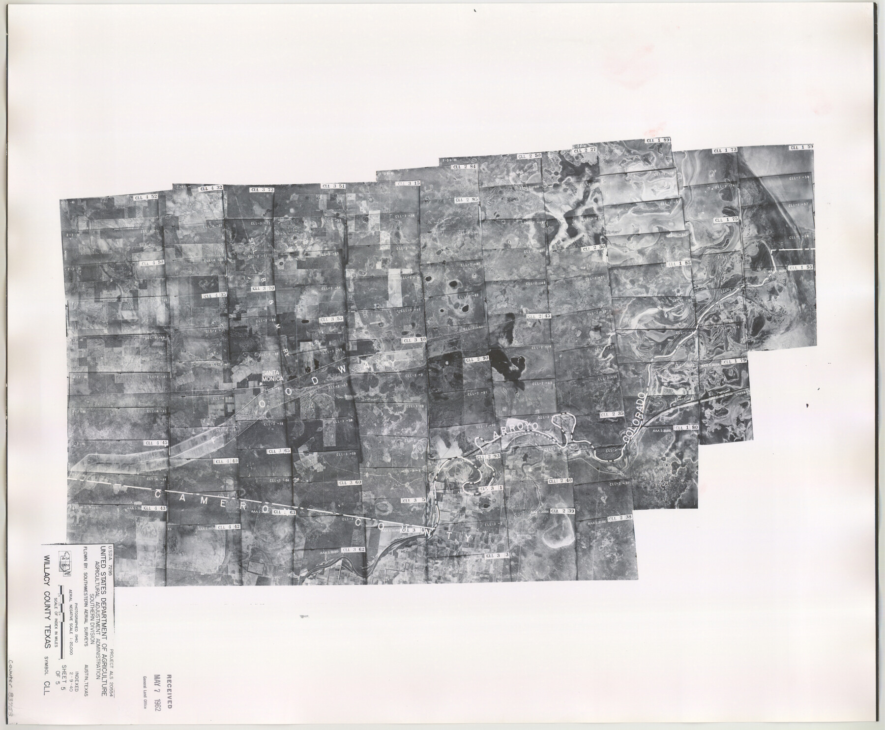
Willacy County Aerial Photograph Index Sheet 5
Willacy County Aerial Photograph Index 4
-
Map/Doc
83758
-
Collection
General Map Collection
-
Object Dates
1940/1/25 (Creation Date)
-
People and Organizations
U. S. Department of Agriculture (Publisher)
-
Counties
Nueces
-
Subjects
Aerial Photograph
-
Height x Width
20.1 x 24.4 inches
51.1 x 62.0 cm
-
Comments
Flying completed January 1940 by Southwestern Aerial Surveys of Austin, Texas.
Received in office May 7, 1962.
Part of: General Map Collection
Lampasas County Boundary File 8

Print $67.00
- Digital $50.00
Lampasas County Boundary File 8
Size 11.0 x 17.0 inches
Map/Doc 56158
Flight Mission No. CRE-1R, Frame 192, Jackson County

Print $20.00
- Digital $50.00
Flight Mission No. CRE-1R, Frame 192, Jackson County
1956
Size 18.5 x 22.3 inches
Map/Doc 85346
Duval County Rolled Sketch WSR

Print $20.00
- Digital $50.00
Duval County Rolled Sketch WSR
1938
Size 39.2 x 26.8 inches
Map/Doc 5772
Lubbock County Sketch File 6

Print $20.00
- Digital $50.00
Lubbock County Sketch File 6
1902
Size 33.0 x 20.8 inches
Map/Doc 12017
Aransas County Working Sketch Graphic Index

Print $20.00
- Digital $50.00
Aransas County Working Sketch Graphic Index
1947
Size 36.8 x 36.6 inches
Map/Doc 76455
Schleicher County Sketch File 12

Print $8.00
- Digital $50.00
Schleicher County Sketch File 12
1915
Size 14.3 x 8.9 inches
Map/Doc 36489
Township 6 North Range 13 West, North Western District, Louisiana

Print $20.00
- Digital $50.00
Township 6 North Range 13 West, North Western District, Louisiana
1841
Size 19.7 x 24.8 inches
Map/Doc 65864
San Jacinto County Working Sketch 42b

Print $3.00
- Digital $50.00
San Jacinto County Working Sketch 42b
1979
Size 10.7 x 14.4 inches
Map/Doc 63756
Hall County Rolled Sketch 6

Print $20.00
- Digital $50.00
Hall County Rolled Sketch 6
Size 24.9 x 41.2 inches
Map/Doc 6050
Map of the Public Land States and Territories constructed from the Public Surveys and other official sources in the General Land Office

Print $20.00
- Digital $50.00
Map of the Public Land States and Territories constructed from the Public Surveys and other official sources in the General Land Office
Size 31.0 x 46.6 inches
Map/Doc 94152
Sutton County Rolled Sketch 51

Print $20.00
- Digital $50.00
Sutton County Rolled Sketch 51
1950
Size 29.6 x 16.4 inches
Map/Doc 7891
Flight Mission No. DQO-13T, Frame 48, Galveston County

Print $20.00
- Digital $50.00
Flight Mission No. DQO-13T, Frame 48, Galveston County
1958
Size 18.5 x 18.2 inches
Map/Doc 85212
You may also like
Stephens County

Print $20.00
- Digital $50.00
Stephens County
1940
Size 42.5 x 40.4 inches
Map/Doc 73293
Webb County Working Sketch 75

Print $40.00
- Digital $50.00
Webb County Working Sketch 75
1975
Size 59.2 x 46.0 inches
Map/Doc 72442
Galveston County NRC Article 33.136 Sketch 13

Print $20.00
- Digital $50.00
Galveston County NRC Article 33.136 Sketch 13
2002
Size 17.9 x 22.4 inches
Map/Doc 77044
Aransas County Rolled Sketch 25

Print $20.00
- Digital $50.00
Aransas County Rolled Sketch 25
1983
Size 18.4 x 24.5 inches
Map/Doc 5061
Lubbock County Working Sketch 5

Print $20.00
- Digital $50.00
Lubbock County Working Sketch 5
1950
Size 14.3 x 31.0 inches
Map/Doc 70665
[Map Showing Surveys in Dimmit & La Salle Counties, Texas]
![75792, [Map Showing Surveys in Dimmit & La Salle Counties, Texas], Maddox Collection](https://historictexasmaps.com/wmedia_w700/maps/75792.tif.jpg)
Print $20.00
- Digital $50.00
[Map Showing Surveys in Dimmit & La Salle Counties, Texas]
1882
Size 32.6 x 28.7 inches
Map/Doc 75792

Garza County Rolled Sketch 9

Print $20.00
- Digital $50.00
Garza County Rolled Sketch 9
1913
Size 33.8 x 43.8 inches
Map/Doc 9054
[F. W. & D. C. Ry. Co. Alignment and Right of Way Map, Clay County]
![64728, [F. W. & D. C. Ry. Co. Alignment and Right of Way Map, Clay County], General Map Collection](https://historictexasmaps.com/wmedia_w700/maps/64728-1.tif.jpg)
Print $20.00
- Digital $50.00
[F. W. & D. C. Ry. Co. Alignment and Right of Way Map, Clay County]
1927
Size 18.8 x 11.7 inches
Map/Doc 64728
Brewster County Rolled Sketch K

Print $20.00
- Digital $50.00
Brewster County Rolled Sketch K
1884
Size 19.6 x 13.9 inches
Map/Doc 5321
Wise County Sketch File 26b

Print $20.00
- Digital $50.00
Wise County Sketch File 26b
1855
Size 13.3 x 19.9 inches
Map/Doc 12700
Floyd County Sketch File 9

Print $20.00
- Digital $50.00
Floyd County Sketch File 9
1901
Size 22.1 x 15.3 inches
Map/Doc 11484