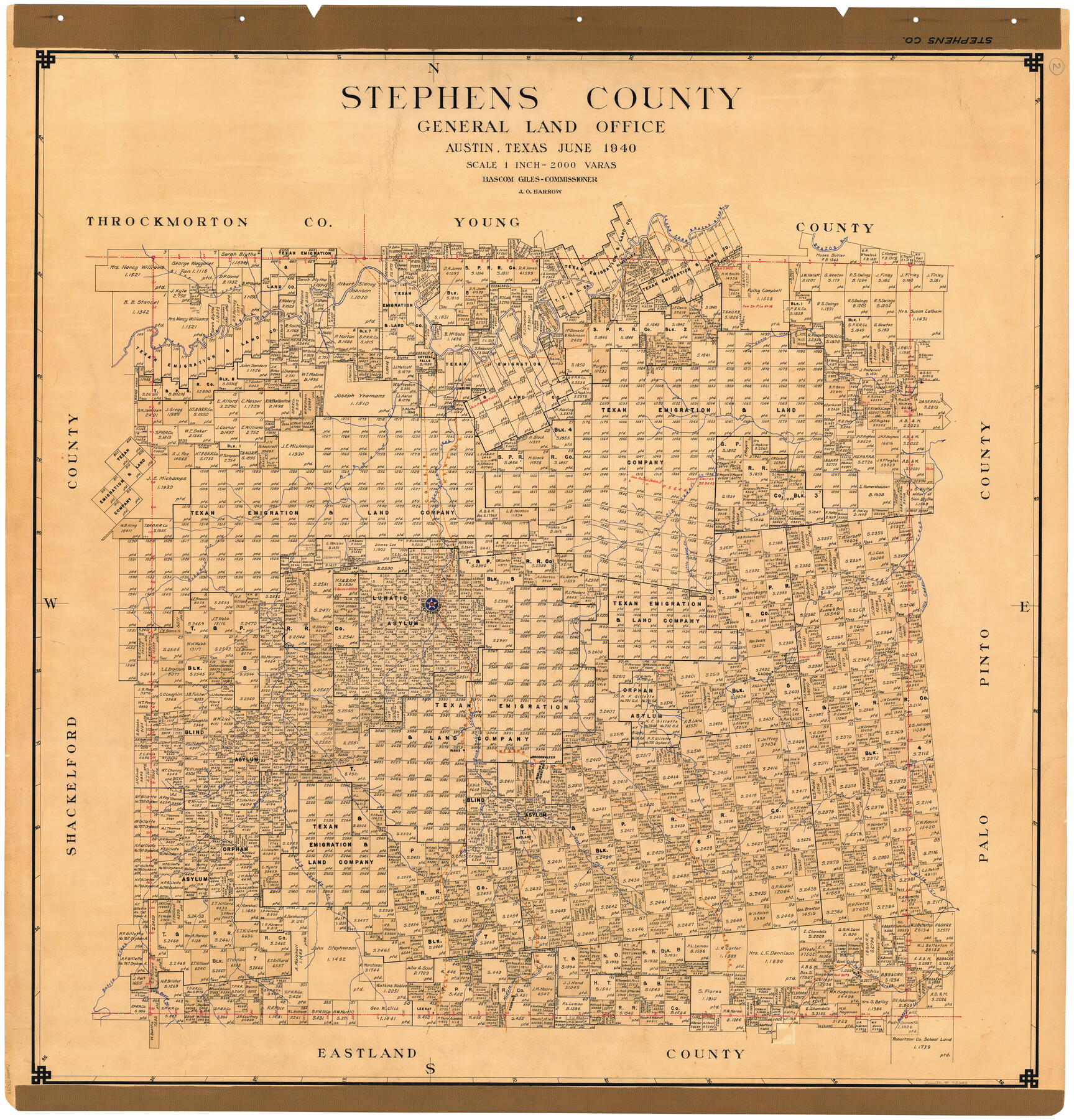
Stephens County
-
Map/Doc
73293
-
Collection
General Map Collection
-
Object Dates
1940 (Creation Date)
-
People and Organizations
Texas General Land Office (Publisher)
Bascom Giles (GLO Commissioner)
J.O. Barrow (Draftsman)
-
Counties
Stephens
-
Subjects
County
-
Height x Width
42.5 x 40.4 inches
108.0 x 102.6 cm
-
Comments
Hand lettered.
Note on reverse side: "In use from November 30, 1940. Replaced [on sticks] by copy June 21, 1946." -
Features
Palo Pinto Creek
Breckwalker
Ringling Junction
Ioni Creek
Big Sandy Creek
Wayland
East Fork of Gonzales Creek
Big Branch of Gonzales Creek
Bills Creek
West Fork of Gonzales Creek
Parks
T&P
Middle Fork of Gonzales Creek
Battle Creek
Board Branch of Battle Creek
Wiles
Russell Creek
Gunsight
Leeray
Gonzales Creek
Eliasville
Clear Fork of Brazos River
Brazos River
Crystal Falls
Veale Creek
Jim Kurn
WF&S
C&NE
Hubbard Creek
Given Creek
Big Cedar Creek
Sandy Creek
Little Cedar Creek
Big Caddo Creek
Little Caddo Creek
Breckenridge
Caddo
Bear Creek
Part of: General Map Collection
Andrews County Working Sketch 27

Print $20.00
- Digital $50.00
Andrews County Working Sketch 27
1984
Size 19.1 x 16.2 inches
Map/Doc 67073
Starr County Rolled Sketch 33

Print $20.00
- Digital $50.00
Starr County Rolled Sketch 33
1944
Size 21.9 x 30.8 inches
Map/Doc 7830
Palo Pinto County Rolled Sketch 10

Print $20.00
- Digital $50.00
Palo Pinto County Rolled Sketch 10
1954
Size 35.4 x 34.1 inches
Map/Doc 9676
Flight Mission No. DAG-21K, Frame 110, Matagorda County

Print $20.00
- Digital $50.00
Flight Mission No. DAG-21K, Frame 110, Matagorda County
1952
Size 18.6 x 22.6 inches
Map/Doc 86438
Lavaca County Sketch File 22

Print $28.00
- Digital $50.00
Lavaca County Sketch File 22
1959
Size 14.2 x 8.7 inches
Map/Doc 29654
Hardeman County

Print $20.00
- Digital $50.00
Hardeman County
1935
Size 46.0 x 42.7 inches
Map/Doc 95520
Brazoria County NRC Article 33.136 Sketch 10

Print $23.00
- Digital $50.00
Brazoria County NRC Article 33.136 Sketch 10
2007
Size 25.7 x 35.7 inches
Map/Doc 87933
Presidio County Working Sketch 70

Print $20.00
- Digital $50.00
Presidio County Working Sketch 70
1961
Size 46.8 x 37.4 inches
Map/Doc 71747
United States, 1956 Revised Edition

Print $40.00
- Digital $50.00
United States, 1956 Revised Edition
1946
Size 48.0 x 36.3 inches
Map/Doc 78631
Dallas County Working Sketch 4

Print $20.00
- Digital $50.00
Dallas County Working Sketch 4
1935
Size 24.1 x 30.4 inches
Map/Doc 68570
Blanco County Rolled Sketch 3

Print $20.00
- Digital $50.00
Blanco County Rolled Sketch 3
Size 14.8 x 13.5 inches
Map/Doc 5142
Flight Mission No. CGI-3N, Frame 97, Cameron County

Print $20.00
- Digital $50.00
Flight Mission No. CGI-3N, Frame 97, Cameron County
1954
Size 18.6 x 22.1 inches
Map/Doc 84577
You may also like
Nueces County Aerial Photograph Index Sheet 22

Print $20.00
- Digital $50.00
Nueces County Aerial Photograph Index Sheet 22
1938
Size 24.5 x 20.3 inches
Map/Doc 86843
McLennan County Working Sketch 3

Print $20.00
- Digital $50.00
McLennan County Working Sketch 3
1941
Size 18.0 x 17.9 inches
Map/Doc 70696
Shelby County Working Sketch 12

Print $40.00
- Digital $50.00
Shelby County Working Sketch 12
1946
Size 53.4 x 36.4 inches
Map/Doc 63865
[Topographical Map]
![92543, [Topographical Map], Twichell Survey Records](https://historictexasmaps.com/wmedia_w700/maps/92543-1.tif.jpg)
Print $20.00
- Digital $50.00
[Topographical Map]
Size 31.2 x 37.5 inches
Map/Doc 92543
Map of Williamson County

Print $20.00
- Digital $50.00
Map of Williamson County
1863
Size 22.7 x 29.7 inches
Map/Doc 4150
Flight Mission No. BQY-14M, Frame 184, Harris County

Print $20.00
- Digital $50.00
Flight Mission No. BQY-14M, Frame 184, Harris County
1953
Size 18.6 x 22.4 inches
Map/Doc 85300
Schleicher County Rolled Sketch 23

Print $20.00
- Digital $50.00
Schleicher County Rolled Sketch 23
1961
Size 30.7 x 22.9 inches
Map/Doc 7762
Webb County Sketch File 46

Print $20.00
- Digital $50.00
Webb County Sketch File 46
1879
Size 19.6 x 14.9 inches
Map/Doc 12644
Crane County State of Texas

Print $20.00
- Digital $50.00
Crane County State of Texas
1889
Size 22.9 x 17.6 inches
Map/Doc 4524
Shamrock, Amended Plat on Section 44, Block 17, Wheeler County, Texas

Print $20.00
- Digital $50.00
Shamrock, Amended Plat on Section 44, Block 17, Wheeler County, Texas
Size 30.0 x 35.5 inches
Map/Doc 92144
Packery Channel

Print $20.00
- Digital $50.00
Packery Channel
1954
Size 16.7 x 19.9 inches
Map/Doc 3002
