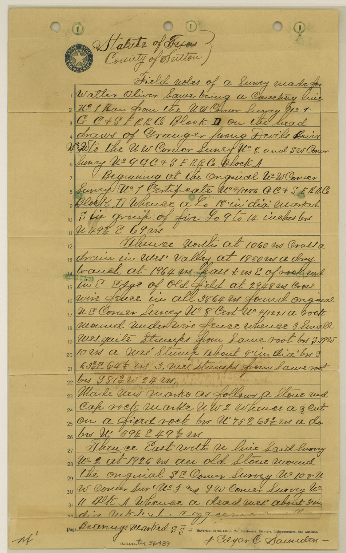
Schleicher County Sketch File 12
[Connecting line - Block A, G.C. & S.F. R.R. Co. in the western part of the county]
-
Map/Doc
36489
-
Collection
General Map Collection
-
Object Dates
12/11/1915 (Creation Date)
4/19/1916 (File Date)
12/10-11/1915 (Survey Date)
-
People and Organizations
Edgar C. Saunders (Surveyor/Engineer)
B.F. Jones (Chainman/Field Personnel)
Garvino Hernandez (Chainman/Field Personnel)
-
Counties
Schleicher
-
Subjects
Surveying Sketch File
-
Height x Width
14.3 x 8.9 inches
36.3 x 22.6 cm
-
Medium
paper, manuscript
-
Features
Granger Prong of Devil's River
Part of: General Map Collection
Leon County Working Sketch 2

Print $20.00
- Digital $50.00
Leon County Working Sketch 2
Size 17.3 x 17.0 inches
Map/Doc 70401
Montague County Rolled Sketch 9

Print $20.00
- Digital $50.00
Montague County Rolled Sketch 9
Size 29.1 x 39.4 inches
Map/Doc 6793
Upper Galveston Bay, Houston Ship Channel, Dollar Pt. to Atkinson I.

Print $40.00
- Digital $50.00
Upper Galveston Bay, Houston Ship Channel, Dollar Pt. to Atkinson I.
1973
Size 49.8 x 36.8 inches
Map/Doc 69896
Andrews County Working Sketch 23

Print $20.00
- Digital $50.00
Andrews County Working Sketch 23
1979
Size 26.6 x 27.7 inches
Map/Doc 67069
Flight Mission No. CUG-1P, Frame 44, Kleberg County

Print $20.00
- Digital $50.00
Flight Mission No. CUG-1P, Frame 44, Kleberg County
1956
Size 18.7 x 22.3 inches
Map/Doc 86122
Red River, Bois D'Arc Creek Floodway Sheet No. 6

Print $20.00
- Digital $50.00
Red River, Bois D'Arc Creek Floodway Sheet No. 6
1917
Size 28.9 x 23.4 inches
Map/Doc 69661
Clay County Boundary File 12

Print $8.00
- Digital $50.00
Clay County Boundary File 12
Size 14.3 x 8.8 inches
Map/Doc 51406
Frio County Working Sketch 28

Print $20.00
- Digital $50.00
Frio County Working Sketch 28
2006
Size 40.8 x 42.0 inches
Map/Doc 83605
Coast Chart No. 210 Aransas Pass and Corpus Christi Bay with the coast to latitude 27° 12' Texas

Print $20.00
- Digital $50.00
Coast Chart No. 210 Aransas Pass and Corpus Christi Bay with the coast to latitude 27° 12' Texas
1887
Size 27.6 x 18.3 inches
Map/Doc 72790
Liberty County Working Sketch 41

Print $20.00
- Digital $50.00
Liberty County Working Sketch 41
1953
Size 21.4 x 20.8 inches
Map/Doc 70500
Map of Blanco County

Print $20.00
- Digital $50.00
Map of Blanco County
1862
Size 28.1 x 18.7 inches
Map/Doc 3303
McLennan County Sketch File 9

Print $4.00
- Digital $50.00
McLennan County Sketch File 9
1849
Size 12.5 x 8.1 inches
Map/Doc 31258
You may also like
Flight Mission No. DQO-8K, Frame 42, Galveston County

Print $20.00
- Digital $50.00
Flight Mission No. DQO-8K, Frame 42, Galveston County
1952
Size 18.5 x 22.3 inches
Map/Doc 85149
Tarrant County Sketch File 35

Print $50.00
Tarrant County Sketch File 35
2018
Size 11.0 x 8.5 inches
Map/Doc 95394
Flight Mission No. CGI-4N, Frame 163, Cameron County

Print $20.00
- Digital $50.00
Flight Mission No. CGI-4N, Frame 163, Cameron County
1955
Size 18.6 x 22.3 inches
Map/Doc 84671
Bowie County Rolled Sketch 4

Print $20.00
- Digital $50.00
Bowie County Rolled Sketch 4
Size 46.1 x 43.6 inches
Map/Doc 8456
Galveston County Sketch File 24

Print $20.00
- Digital $50.00
Galveston County Sketch File 24
Size 15.8 x 18.1 inches
Map/Doc 11531
Brazos River, Koy Bridge Sheet/Mill Creek

Print $20.00
- Digital $50.00
Brazos River, Koy Bridge Sheet/Mill Creek
1933
Size 44.0 x 27.3 inches
Map/Doc 65290
County Map of the Pan-Handle of Texas and the line of the Texas Pan-Handle Route

Print $20.00
- Digital $50.00
County Map of the Pan-Handle of Texas and the line of the Texas Pan-Handle Route
1900
Size 7.2 x 10.3 inches
Map/Doc 95888
Smith County Sketch File 19

Print $42.00
- Digital $50.00
Smith County Sketch File 19
1850
Size 8.1 x 13.0 inches
Map/Doc 36794
[Surveys in the Milam District on Coryell Creek and the Bosque River]
![3171, [Surveys in the Milam District on Coryell Creek and the Bosque River], General Map Collection](https://historictexasmaps.com/wmedia_w700/maps/3171.tif.jpg)
Print $20.00
- Digital $50.00
[Surveys in the Milam District on Coryell Creek and the Bosque River]
1846
Size 14.0 x 15.8 inches
Map/Doc 3171
Lampasas County Sketch File 9b

Print $40.00
- Digital $50.00
Lampasas County Sketch File 9b
1873
Size 7.6 x 20.1 inches
Map/Doc 29412
Presidio County Rolled Sketch 81

Print $20.00
- Digital $50.00
Presidio County Rolled Sketch 81
Size 19.2 x 36.8 inches
Map/Doc 7368
