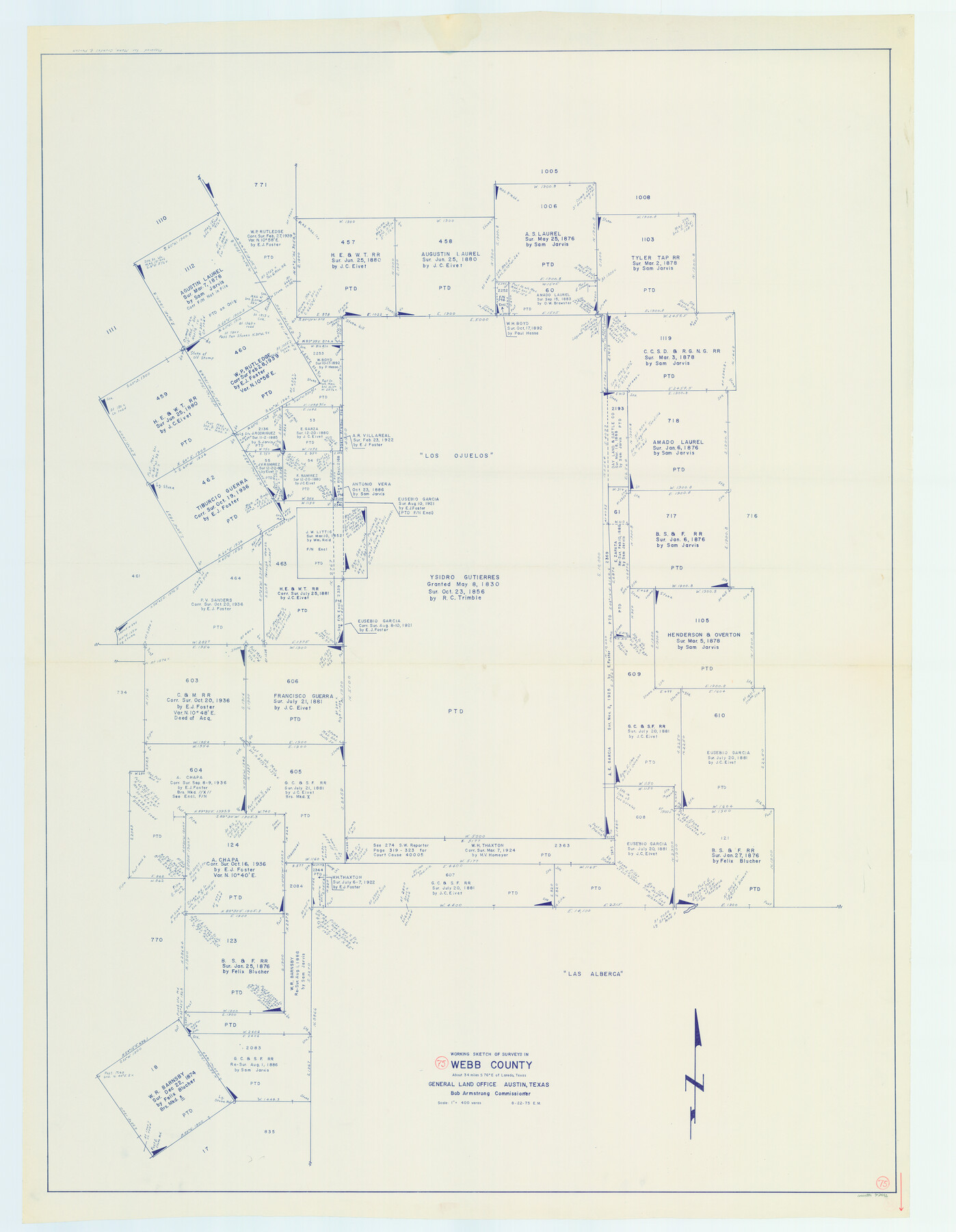
Webb County Working Sketch 75
-
Map/Doc
72442
-
Collection
General Map Collection
-
Object Dates
8/22/1975 (Creation Date)
-
People and Organizations
Elbert Menzel (Draftsman)
-
Counties
Webb
-
Subjects
Surveying Working Sketch
-
Height x Width
59.2 x 46.0 inches
150.4 x 116.8 cm
-
Scale
1" = 400 varas
Part of: General Map Collection
Jefferson County NRC Article 33.136 Sketch 5

Print $4.00
- Digital $50.00
Jefferson County NRC Article 33.136 Sketch 5
2005
Size 14.1 x 8.8 inches
Map/Doc 83170
Morris County Rolled Sketch 2A

Print $20.00
- Digital $50.00
Morris County Rolled Sketch 2A
Size 34.7 x 24.7 inches
Map/Doc 10229
Hockley County Sketch File 19b

Print $28.00
- Digital $50.00
Hockley County Sketch File 19b
Size 11.3 x 8.8 inches
Map/Doc 26555
Erath County Working Sketch 21

Print $20.00
- Digital $50.00
Erath County Working Sketch 21
1965
Size 23.9 x 19.8 inches
Map/Doc 69102

Tarrant County

Print $20.00
- Digital $50.00
Tarrant County
1883
Size 35.5 x 32.8 inches
Map/Doc 4676

Harris County Sketch File 22

Print $4.00
- Digital $50.00
Harris County Sketch File 22
1862
Size 9.1 x 9.4 inches
Map/Doc 25375
Pecos County Working Sketch 48

Print $20.00
- Digital $50.00
Pecos County Working Sketch 48
1947
Size 35.0 x 27.7 inches
Map/Doc 71520
Brewster County Rolled Sketch 95

Print $20.00
- Digital $50.00
Brewster County Rolled Sketch 95
1947
Size 29.4 x 38.0 inches
Map/Doc 5252
Reeves County Rolled Sketch 37

Print $20.00
- Digital $50.00
Reeves County Rolled Sketch 37
2017
Size 22.9 x 17.1 inches
Map/Doc 95203
Fort Bend County Working Sketch 19

Print $20.00
- Digital $50.00
Fort Bend County Working Sketch 19
1959
Size 26.3 x 29.9 inches
Map/Doc 69225
You may also like
Edwards County Working Sketch 79

Print $40.00
- Digital $50.00
Edwards County Working Sketch 79
1962
Size 58.5 x 26.6 inches
Map/Doc 68955
[Surveys along the Colorado River]
![119, [Surveys along the Colorado River], General Map Collection](https://historictexasmaps.com/wmedia_w700/maps/119.tif.jpg)
Print $20.00
- Digital $50.00
[Surveys along the Colorado River]
1840
Size 23.8 x 17.9 inches
Map/Doc 119
Panola County

Print $20.00
- Digital $50.00
Panola County
1947
Size 40.8 x 40.3 inches
Map/Doc 66969
Flight Mission No. DQO-8K, Frame 10, Galveston County

Print $20.00
- Digital $50.00
Flight Mission No. DQO-8K, Frame 10, Galveston County
1952
Size 18.7 x 22.4 inches
Map/Doc 85133
Texas Gulf Coast from Sabine River to Rio Grande As Subdivided for Mineral Development - Obsolete

Print $40.00
- Digital $50.00
Texas Gulf Coast from Sabine River to Rio Grande As Subdivided for Mineral Development - Obsolete
1948
Size 42.0 x 70.8 inches
Map/Doc 2946
Galveston County Working Sketch 8

Print $20.00
- Digital $50.00
Galveston County Working Sketch 8
1939
Size 43.4 x 39.6 inches
Map/Doc 69345
Castro County Sketch File 10

Print $6.00
- Digital $50.00
Castro County Sketch File 10
1916
Size 8.2 x 5.4 inches
Map/Doc 17501

[Titles along the Trinity River]
![175, [Titles along the Trinity River], General Map Collection](https://historictexasmaps.com/wmedia_w700/maps/175.tif.jpg)
Print $3.00
- Digital $50.00
[Titles along the Trinity River]
Size 10.6 x 15.8 inches
Map/Doc 175
Swisher County Rolled Sketch 6

Print $20.00
- Digital $50.00
Swisher County Rolled Sketch 6
1941
Size 43.0 x 27.6 inches
Map/Doc 7907
Ward County Working Sketch 17

Print $20.00
- Digital $50.00
Ward County Working Sketch 17
1948
Size 30.1 x 32.5 inches
Map/Doc 72323
Archer County Working Sketch 4

Print $40.00
- Digital $50.00
Archer County Working Sketch 4
1918
Size 49.9 x 68.3 inches
Map/Doc 67144