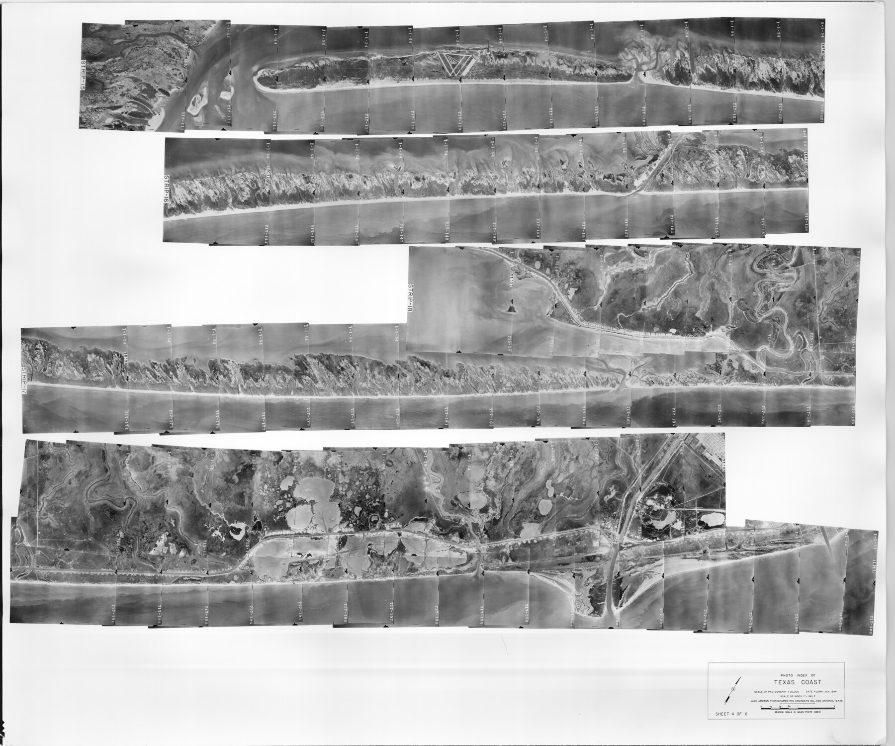
Photo Index of Texas Coast - Sheet 4 of 6
-
Map/Doc
83442
-
Collection
General Map Collection
-
Object Dates
1954 (Creation Date)
-
Subjects
Aerial Photograph
-
Height x Width
20.0 x 24.0 inches
50.8 x 61.0 cm
-
Comments
Statement on reverse side: "The reverse reflects the data shown thereon which was obtained by aerial survey made from December 31, 1953 to March 17, 1954 by Jack Ammann Photogrammetric Engineers, Inc."
Part of: General Map Collection
Leon County Working Sketch 10

Print $20.00
- Digital $50.00
Leon County Working Sketch 10
1951
Size 21.5 x 17.3 inches
Map/Doc 70409
Sketches of Surveys in Jefferson County

Print $2.00
- Digital $50.00
Sketches of Surveys in Jefferson County
1841
Size 7.5 x 7.0 inches
Map/Doc 326
Glasscock County Sketch File 2

Print $20.00
- Digital $50.00
Glasscock County Sketch File 2
1931
Size 35.1 x 16.2 inches
Map/Doc 11559
Flight Mission No. BRE-1P, Frame 148, Nueces County

Print $20.00
- Digital $50.00
Flight Mission No. BRE-1P, Frame 148, Nueces County
1956
Size 18.6 x 22.7 inches
Map/Doc 86708
Houston County Working Sketch 30

Print $20.00
- Digital $50.00
Houston County Working Sketch 30
1990
Size 36.9 x 37.0 inches
Map/Doc 66260
Topographical Map of the Rio Grande, Sheet No. 27

Print $20.00
- Digital $50.00
Topographical Map of the Rio Grande, Sheet No. 27
1912
Map/Doc 89551
El Paso County Working Sketch 23

Print $20.00
- Digital $50.00
El Paso County Working Sketch 23
1961
Size 22.3 x 28.8 inches
Map/Doc 69045
Morris County Rolled Sketch 2A

Print $20.00
- Digital $50.00
Morris County Rolled Sketch 2A
Size 24.0 x 18.8 inches
Map/Doc 10240
Terrell County Working Sketch 77

Print $20.00
- Digital $50.00
Terrell County Working Sketch 77
1983
Size 22.9 x 33.7 inches
Map/Doc 69598
Flight Mission No. DQN-2K, Frame 76, Calhoun County

Print $20.00
- Digital $50.00
Flight Mission No. DQN-2K, Frame 76, Calhoun County
1953
Size 18.8 x 22.3 inches
Map/Doc 84268
Jefferson County Rolled Sketch 52

Print $40.00
- Digital $50.00
Jefferson County Rolled Sketch 52
Size 28.2 x 52.9 inches
Map/Doc 9308
Webb County Rolled Sketch 3

Print $20.00
- Digital $50.00
Webb County Rolled Sketch 3
1884
Size 19.7 x 24.8 inches
Map/Doc 8170
You may also like
[G. C. & S. F. Ry. Northern-Division, Alignment and Right of Way Map, Weatherford Branch, Johnson and Hood Counties, Texas]
![64648, [G. C. & S. F. Ry. Northern-Division, Alignment and Right of Way Map, Weatherford Branch, Johnson and Hood Counties, Texas], General Map Collection](https://historictexasmaps.com/wmedia_w700/maps/64648.tif.jpg)
Print $40.00
- Digital $50.00
[G. C. & S. F. Ry. Northern-Division, Alignment and Right of Way Map, Weatherford Branch, Johnson and Hood Counties, Texas]
1935
Size 37.4 x 120.9 inches
Map/Doc 64648
Duval County Sketch File 87

Print $12.00
- Digital $50.00
Duval County Sketch File 87
1991
Size 11.0 x 8.5 inches
Map/Doc 21549
Kinney County Sketch File 15

Print $20.00
- Digital $50.00
Kinney County Sketch File 15
1887
Size 13.0 x 19.0 inches
Map/Doc 11940
Van Zandt County Sketch File 46

Print $2.00
- Digital $50.00
Van Zandt County Sketch File 46
Size 8.0 x 12.7 inches
Map/Doc 39503
La Salle County Working Sketch 38

Print $20.00
- Digital $50.00
La Salle County Working Sketch 38
1961
Size 26.6 x 18.4 inches
Map/Doc 70339
[Sketch for Mineral Application 36486 and 38244 - Liberty County]
![65622, [Sketch for Mineral Application 36486 and 38244 - Liberty County], General Map Collection](https://historictexasmaps.com/wmedia_w700/maps/65622.tif.jpg)
Print $20.00
- Digital $50.00
[Sketch for Mineral Application 36486 and 38244 - Liberty County]
1976
Size 24.0 x 43.9 inches
Map/Doc 65622
General Highway Map, Jones County, Texas

Print $20.00
General Highway Map, Jones County, Texas
1940
Size 18.5 x 24.8 inches
Map/Doc 79150
Coleman County Sketch File 35

Print $2.00
- Digital $50.00
Coleman County Sketch File 35
Size 8.4 x 8.2 inches
Map/Doc 18740
Willacy County Aerial Photograph Index Sheet 1

Print $20.00
- Digital $50.00
Willacy County Aerial Photograph Index Sheet 1
1940
Size 24.3 x 20.2 inches
Map/Doc 83756
Flight Mission No. BRA-7M, Frame 198, Jefferson County

Print $20.00
- Digital $50.00
Flight Mission No. BRA-7M, Frame 198, Jefferson County
1953
Size 18.7 x 22.4 inches
Map/Doc 85566
Morris County Rolled Sketch 2A

Print $20.00
- Digital $50.00
Morris County Rolled Sketch 2A
Size 24.2 x 19.1 inches
Map/Doc 10267
Upton County Rolled Sketch 14

Print $20.00
- Digital $50.00
Upton County Rolled Sketch 14
Size 43.2 x 32.0 inches
Map/Doc 10038