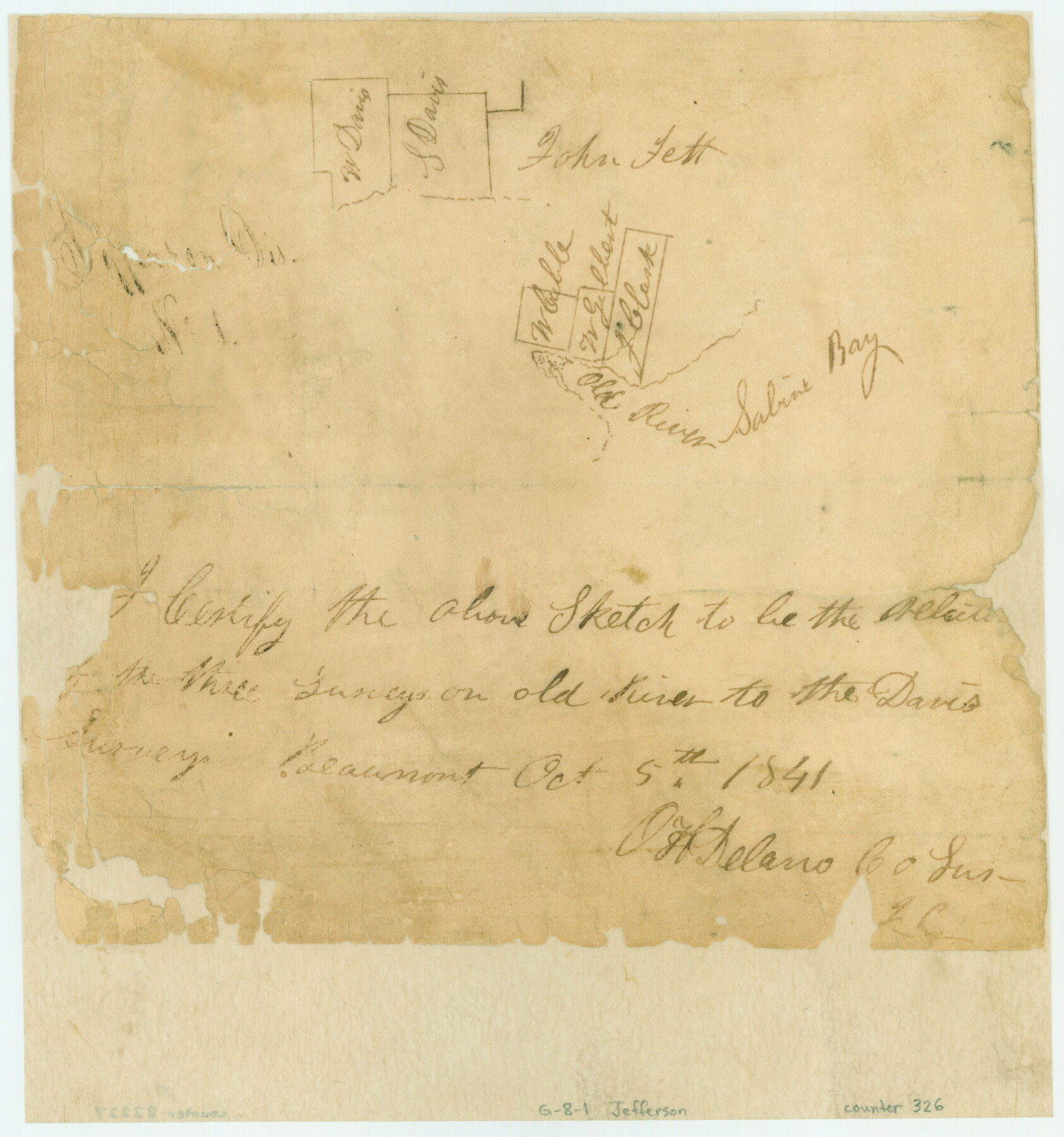
Sketches of Surveys in Jefferson County
Atlas G, Page 8, Sketch 1 (G-8-1)
G-8-1
-
Map/Doc
326
-
Collection
General Map Collection
-
Object Dates
1841 (Creation Date)
-
People and Organizations
O.H. Delano (Surveyor/Engineer)
-
Counties
Orange
-
Subjects
Atlas
-
Height x Width
7.5 x 7.0 inches
19.1 x 17.8 cm
-
Medium
paper, manuscript
-
Comments
Conserved in 2003.
-
Features
Old River
Sabine Bay
Part of: General Map Collection
Flight Mission No. DQO-2K, Frame 142, Galveston County

Print $20.00
- Digital $50.00
Flight Mission No. DQO-2K, Frame 142, Galveston County
1952
Size 18.8 x 22.4 inches
Map/Doc 85039
[Atchison, Topeka & Santa Fe from Paisano to south of Plata]
![64713, [Atchison, Topeka & Santa Fe from Paisano to south of Plata], General Map Collection](https://historictexasmaps.com/wmedia_w700/maps/64713-1.tif.jpg)
Print $40.00
- Digital $50.00
[Atchison, Topeka & Santa Fe from Paisano to south of Plata]
Size 32.2 x 116.3 inches
Map/Doc 64713
Matagorda County NRC Article 33.136 Sketch 18

Print $24.00
Matagorda County NRC Article 33.136 Sketch 18
2023
Map/Doc 97283
Real County Sketch File 3

Print $16.00
- Digital $50.00
Real County Sketch File 3
1906
Size 9.2 x 8.2 inches
Map/Doc 35039
[F. W. & D. C. Ry. Co. Alignment and Right of Way Map, Clay County]
![64734, [F. W. & D. C. Ry. Co. Alignment and Right of Way Map, Clay County], General Map Collection](https://historictexasmaps.com/wmedia_w700/maps/64734-GC.tif.jpg)
Print $20.00
- Digital $50.00
[F. W. & D. C. Ry. Co. Alignment and Right of Way Map, Clay County]
1927
Size 18.6 x 11.8 inches
Map/Doc 64734
Young County Rolled Sketch 2

Print $20.00
- Digital $50.00
Young County Rolled Sketch 2
Size 26.2 x 25.0 inches
Map/Doc 8292
Chambers County Sketch File 4a

Print $19.00
- Digital $50.00
Chambers County Sketch File 4a
1839
Size 11.4 x 17.8 inches
Map/Doc 17523
Northwest Part of Webb County

Print $40.00
- Digital $50.00
Northwest Part of Webb County
1984
Size 43.2 x 52.9 inches
Map/Doc 95669
State Highway System of Texas Showing Condition of Improvement

Print $5.00
- Digital $50.00
State Highway System of Texas Showing Condition of Improvement
1929
Size 28.5 x 30.9 inches
Map/Doc 93720
Reeves County Sketch File 3

Print $8.00
- Digital $50.00
Reeves County Sketch File 3
Size 14.4 x 8.8 inches
Map/Doc 35188
Howard County Sketch File 10

Print $20.00
- Digital $50.00
Howard County Sketch File 10
Size 22.5 x 22.0 inches
Map/Doc 11798
Rusk County Sketch File 40

Print $20.00
Rusk County Sketch File 40
1951
Size 23.2 x 26.6 inches
Map/Doc 12276
You may also like
Flight Mission No. BQR-22K, Frame 36, Brazoria County

Print $20.00
- Digital $50.00
Flight Mission No. BQR-22K, Frame 36, Brazoria County
1953
Size 18.6 x 22.4 inches
Map/Doc 84120
Winkler County Rolled Sketch 16

Print $20.00
- Digital $50.00
Winkler County Rolled Sketch 16
1927
Size 22.5 x 32.6 inches
Map/Doc 8276
Guadalupe-Blanco River Authority Master Plan

Print $20.00
Guadalupe-Blanco River Authority Master Plan
Size 23.1 x 29.8 inches
Map/Doc 97506
Plat of Jasper, Sabine, San Augustine, Shelby, Harrison and South Part of Nacogdoches Counties

Print $2.00
- Digital $50.00
Plat of Jasper, Sabine, San Augustine, Shelby, Harrison and South Part of Nacogdoches Counties
1841
Size 13.7 x 9.2 inches
Map/Doc 3174
Presidio County Working Sketch 57

Print $20.00
- Digital $50.00
Presidio County Working Sketch 57
1955
Size 47.3 x 39.3 inches
Map/Doc 71734
Aransas County Sketch File 25

Print $20.00
- Digital $50.00
Aransas County Sketch File 25
Size 17.0 x 17.5 inches
Map/Doc 13218
Land of the Maya, a Traveler's Map

Land of the Maya, a Traveler's Map
Size 27.2 x 20.5 inches
Map/Doc 95933
Jefferson County NRC Article 33.136 Sketch 7

Print $24.00
- Digital $50.00
Jefferson County NRC Article 33.136 Sketch 7
2009
Size 30.8 x 43.0 inches
Map/Doc 94711
[Sketch showing C. D. & W. A. Murphy's Pasture and Wint Barfield's Pasture]
![90885, [Sketch showing C. D. & W. A. Murphy's Pasture and Wint Barfield's Pasture], Twichell Survey Records](https://historictexasmaps.com/wmedia_w700/maps/90885-1.tif.jpg)
Print $20.00
- Digital $50.00
[Sketch showing C. D. & W. A. Murphy's Pasture and Wint Barfield's Pasture]
Size 31.9 x 27.4 inches
Map/Doc 90885
[Southwest part of County]
![90921, [Southwest part of County], Twichell Survey Records](https://historictexasmaps.com/wmedia_w700/maps/90921-1.tif.jpg)
Print $20.00
- Digital $50.00
[Southwest part of County]
Size 29.0 x 18.3 inches
Map/Doc 90921
Sutton County Working Sketch 24

Print $20.00
- Digital $50.00
Sutton County Working Sketch 24
1985
Size 32.6 x 42.5 inches
Map/Doc 62367
Cogdell Ranch Kent County, Texas

Print $20.00
- Digital $50.00
Cogdell Ranch Kent County, Texas
1950
Size 24.8 x 13.5 inches
Map/Doc 92189