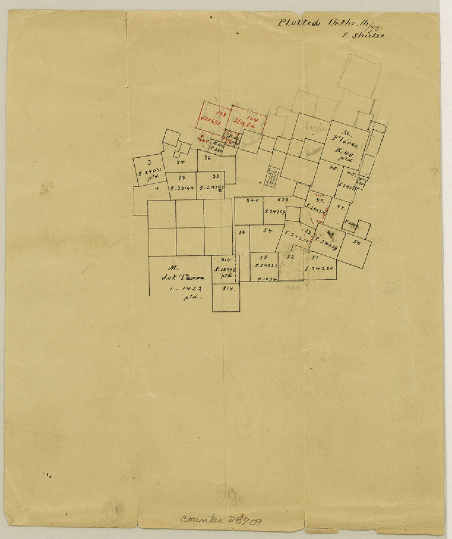
Kendall County Sketch File 17
[Office sketch north of Boerne]
-
Map/Doc
28709
-
Collection
General Map Collection
-
Object Dates
10/16/1878 (Creation Date)
10/16/1878 (File Date)
-
People and Organizations
E. Schutze (Draftsman)
-
Counties
Kendall
-
Subjects
Surveying Sketch File
-
Height x Width
9.1 x 7.6 inches
23.1 x 19.3 cm
-
Medium
paper, manuscript
Part of: General Map Collection
[Surveys in Austin's Colony along the San Antonio Road and the Navasota River]
![202, [Surveys in Austin's Colony along the San Antonio Road and the Navasota River], General Map Collection](https://historictexasmaps.com/wmedia_w700/maps/202.tif.jpg)
Print $20.00
- Digital $50.00
[Surveys in Austin's Colony along the San Antonio Road and the Navasota River]
1833
Size 16.1 x 34.7 inches
Map/Doc 202
Hemphill County Rolled Sketch 13

Print $20.00
- Digital $50.00
Hemphill County Rolled Sketch 13
1905
Size 20.7 x 28.9 inches
Map/Doc 6193
Falls County Sketch File 32

Print $20.00
- Digital $50.00
Falls County Sketch File 32
Size 36.3 x 24.7 inches
Map/Doc 11468
Flight Mission No. DIX-6P, Frame 198, Aransas County

Print $20.00
- Digital $50.00
Flight Mission No. DIX-6P, Frame 198, Aransas County
1956
Size 19.1 x 22.9 inches
Map/Doc 83860
Laguna Madre, Register No. 1477A

Print $40.00
- Digital $50.00
Laguna Madre, Register No. 1477A
1880
Size 34.3 x 56.0 inches
Map/Doc 73606
Jefferson County Working Sketch 36

Print $40.00
- Digital $50.00
Jefferson County Working Sketch 36
1982
Size 69.1 x 33.2 inches
Map/Doc 66580
Mills County Sketch File 14

Print $4.00
- Digital $50.00
Mills County Sketch File 14
1871
Size 6.8 x 8.0 inches
Map/Doc 31661
Henderson County Boundary File 3c

Print $40.00
- Digital $50.00
Henderson County Boundary File 3c
Size 22.5 x 80.6 inches
Map/Doc 54707
Hunt County Sketch File 11

Print $4.00
- Digital $50.00
Hunt County Sketch File 11
1860
Size 12.1 x 7.6 inches
Map/Doc 27102
Orange County Working Sketch 50

Print $20.00
- Digital $50.00
Orange County Working Sketch 50
1991
Size 36.0 x 43.6 inches
Map/Doc 71382
Hardin County Rolled Sketch 21

Print $20.00
- Digital $50.00
Hardin County Rolled Sketch 21
1966
Size 18.8 x 22.7 inches
Map/Doc 6090
Parker County Sketch File 11

Print $4.00
- Digital $50.00
Parker County Sketch File 11
1859
Size 12.8 x 8.1 inches
Map/Doc 33542
You may also like
Houston County Working Sketch 36

Print $40.00
- Digital $50.00
Houston County Working Sketch 36
1987
Size 61.2 x 43.6 inches
Map/Doc 78231
San Augustine County Working Sketch 8

Print $20.00
- Digital $50.00
San Augustine County Working Sketch 8
1935
Size 24.8 x 35.0 inches
Map/Doc 63695
Mrs. W. H. Bledsoe Farm NE 100.2 Acres of Section 37, Block AK

Print $20.00
- Digital $50.00
Mrs. W. H. Bledsoe Farm NE 100.2 Acres of Section 37, Block AK
Size 15.9 x 13.0 inches
Map/Doc 92274
Map of the United States

Print $20.00
- Digital $50.00
Map of the United States
1851
Size 25.1 x 25.3 inches
Map/Doc 93899
New Hobbs, Lea County, New Mexico

Print $20.00
- Digital $50.00
New Hobbs, Lea County, New Mexico
Size 15.7 x 20.1 inches
Map/Doc 92424
[Blks. B9, J, D19, John Walker]
![90482, [Blks. B9, J, D19, John Walker], Twichell Survey Records](https://historictexasmaps.com/wmedia_w700/maps/90482-1.tif.jpg)
Print $20.00
- Digital $50.00
[Blks. B9, J, D19, John Walker]
Size 27.8 x 15.9 inches
Map/Doc 90482
Henderson County Sketch File 18

Print $20.00
- Digital $50.00
Henderson County Sketch File 18
1936
Size 16.7 x 18.3 inches
Map/Doc 11756
Loving County Working Sketch 9

Print $20.00
- Digital $50.00
Loving County Working Sketch 9
1952
Size 24.8 x 45.8 inches
Map/Doc 70641
Deaf Smith County

Print $20.00
- Digital $50.00
Deaf Smith County
1926
Size 32.9 x 41.3 inches
Map/Doc 77260
El Paso County Working Sketch 35

Print $20.00
- Digital $50.00
El Paso County Working Sketch 35
1977
Size 19.8 x 30.3 inches
Map/Doc 69057
Terry County Working Sketch 3

Print $40.00
- Digital $50.00
Terry County Working Sketch 3
1953
Size 125.9 x 28.4 inches
Map/Doc 62108
Bray Subdivision and McElroy Subdivision

Print $20.00
- Digital $50.00
Bray Subdivision and McElroy Subdivision
Size 19.3 x 25.2 inches
Map/Doc 92746