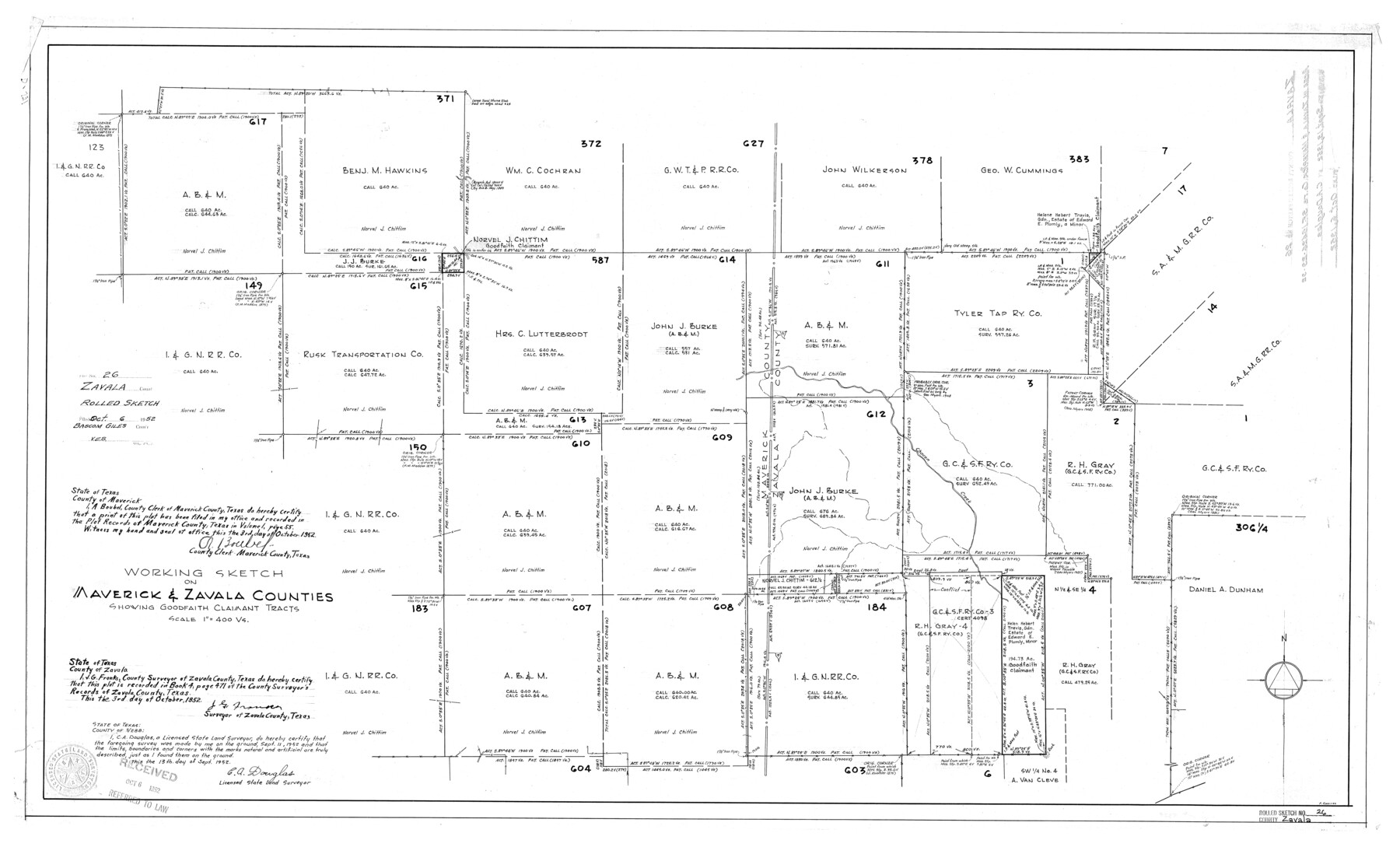
Zavala County Rolled Sketch 26
Working sketch on Maverick & Zavala Counties showing Good Faith Claimant tracts
-
Map/Doc
8328
-
Collection
General Map Collection
-
Object Dates
1952/9/13 (Creation Date)
1952/10/6 (File Date)
1952/9/11 (Survey Date)
-
People and Organizations
C.A. Douglas (Surveyor/Engineer)
-
Counties
Zavala Maverick
-
Subjects
Surveying Rolled Sketch
-
Height x Width
25.3 x 41.8 inches
64.3 x 106.2 cm
-
Medium
linen, manuscript
-
Scale
1" = 400 varas
Part of: General Map Collection
Flight Mission No. CLL-1N, Frame 81, Willacy County

Print $20.00
- Digital $50.00
Flight Mission No. CLL-1N, Frame 81, Willacy County
1954
Size 18.3 x 22.1 inches
Map/Doc 87027
Archer County Sketch File 28-1

Print $40.00
- Digital $50.00
Archer County Sketch File 28-1
1928
Size 23.8 x 22.0 inches
Map/Doc 10834
King County Rolled Sketch 13

Print $40.00
- Digital $50.00
King County Rolled Sketch 13
Size 50.5 x 29.3 inches
Map/Doc 9353
Wilbarger Co.

Print $40.00
- Digital $50.00
Wilbarger Co.
1949
Size 48.2 x 38.8 inches
Map/Doc 95674
Kinney County Working Sketch 33

Print $20.00
- Digital $50.00
Kinney County Working Sketch 33
1962
Size 39.0 x 44.2 inches
Map/Doc 70215
Wise County Rolled Sketch 5

Print $20.00
- Digital $50.00
Wise County Rolled Sketch 5
Size 19.4 x 21.4 inches
Map/Doc 8271
Hudspeth County Working Sketch 36

Print $40.00
- Digital $50.00
Hudspeth County Working Sketch 36
1977
Size 63.1 x 37.2 inches
Map/Doc 66321
Maverick County Sketch File 3a

Print $34.00
- Digital $50.00
Maverick County Sketch File 3a
Size 10.0 x 8.0 inches
Map/Doc 31035
Brazoria County NRC Article 33.136 Sketch 6

Print $22.00
- Digital $50.00
Brazoria County NRC Article 33.136 Sketch 6
2004
Size 24.6 x 35.2 inches
Map/Doc 82904

Brewster County Rolled Sketch 114

Print $20.00
- Digital $50.00
Brewster County Rolled Sketch 114
1964
Size 11.1 x 18.4 inches
Map/Doc 5270
[Galveston, Harrisburg & San Antonio Railroad from Cuero to Stockdale]
![64194, [Galveston, Harrisburg & San Antonio Railroad from Cuero to Stockdale], General Map Collection](https://historictexasmaps.com/wmedia_w700/maps/64194.tif.jpg)
Print $20.00
- Digital $50.00
[Galveston, Harrisburg & San Antonio Railroad from Cuero to Stockdale]
1907
Size 13.6 x 34.0 inches
Map/Doc 64194
You may also like
Nueces County Rolled Sketch 129

Print $20.00
- Digital $50.00
Nueces County Rolled Sketch 129
1998
Size 18.1 x 24.5 inches
Map/Doc 7164
Cass County Working Sketch 42

Print $20.00
- Digital $50.00
Cass County Working Sketch 42
1986
Size 36.4 x 37.5 inches
Map/Doc 67945
Flight Mission No. BRE-1P, Frame 55, Nueces County

Print $20.00
- Digital $50.00
Flight Mission No. BRE-1P, Frame 55, Nueces County
1956
Size 18.3 x 22.2 inches
Map/Doc 86644
Tom Green County Sketch File 77

Print $6.00
- Digital $50.00
Tom Green County Sketch File 77
Size 10.0 x 8.5 inches
Map/Doc 38253
Dr. S. C. Arnett Farm Part Section 5, Block E2

Print $20.00
- Digital $50.00
Dr. S. C. Arnett Farm Part Section 5, Block E2
Size 12.7 x 15.8 inches
Map/Doc 92296
Kimble County Sketch File 31

Print $20.00
- Digital $50.00
Kimble County Sketch File 31
1890
Size 26.0 x 24.3 inches
Map/Doc 11929
Hood County Sketch File 17

Print $4.00
- Digital $50.00
Hood County Sketch File 17
1860
Size 8.2 x 9.4 inches
Map/Doc 26599
Plat made for W. D. Twichell

Print $20.00
- Digital $50.00
Plat made for W. D. Twichell
1919
Size 25.0 x 15.7 inches
Map/Doc 91916
Nueces County Sketch File 32

Print $32.00
- Digital $50.00
Nueces County Sketch File 32
1907
Size 14.2 x 8.7 inches
Map/Doc 32605
[Leagues 656-666, 671-676, 684-688, 692-695]
![91007, [Leagues 656-666, 671-676, 684-688, 692-695], Twichell Survey Records](https://historictexasmaps.com/wmedia_w700/maps/91007-1.tif.jpg)
Print $20.00
- Digital $50.00
[Leagues 656-666, 671-676, 684-688, 692-695]
Size 30.6 x 20.7 inches
Map/Doc 91007
Val Verde County Rolled Sketch 56

Print $20.00
- Digital $50.00
Val Verde County Rolled Sketch 56
1941
Size 39.3 x 22.8 inches
Map/Doc 8125
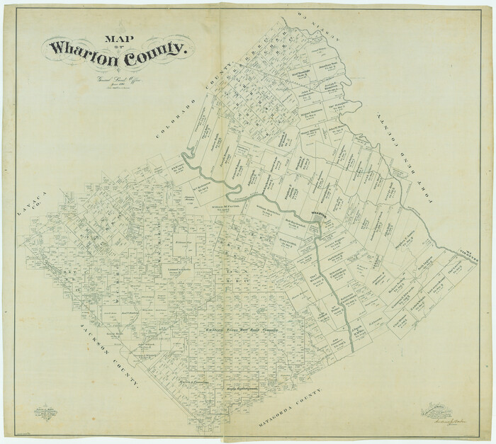
Map of Wharton County
Print $40.00
- Digital $50.00
Map of Wharton County
1895
Size 48.2 x 53.8 inches
Map/Doc 82055