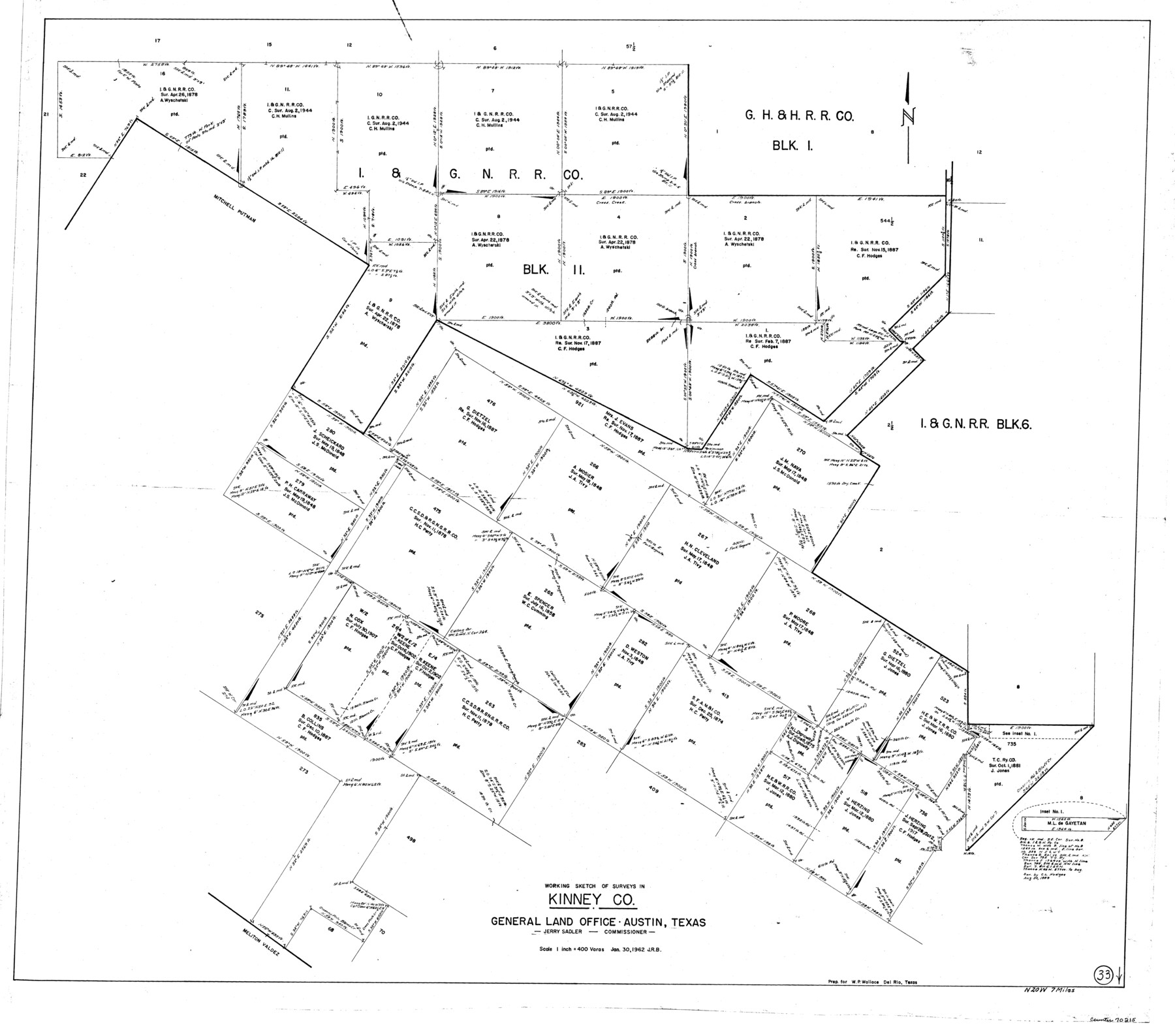
Kinney County Working Sketch 33
-
Map/Doc
70215
-
Collection
General Map Collection
-
Object Dates
1/30/1962 (Creation Date)
-
Counties
Kinney
-
Subjects
Surveying Working Sketch
-
Height x Width
39.0 x 44.2 inches
99.1 x 112.3 cm
-
Scale
1" = 400 varas
Part of: General Map Collection
Crockett County Rolled Sketch 42

Print $20.00
- Digital $50.00
Crockett County Rolled Sketch 42
Size 24.4 x 24.7 inches
Map/Doc 5592
Edwards County Working Sketch 74

Print $20.00
- Digital $50.00
Edwards County Working Sketch 74
1959
Size 23.6 x 38.4 inches
Map/Doc 68950
Flight Mission No. BRA-7M, Frame 141, Jefferson County

Print $20.00
- Digital $50.00
Flight Mission No. BRA-7M, Frame 141, Jefferson County
1953
Size 18.6 x 22.4 inches
Map/Doc 85535
Dimmit County Working Sketch 10

Print $20.00
- Digital $50.00
Dimmit County Working Sketch 10
1934
Size 24.2 x 40.3 inches
Map/Doc 68671
[Sketch for Mineral Application 33721 - 33725 Incl. - Padre and Mustang Island]
![2876, [Sketch for Mineral Application 33721 - 33725 Incl. - Padre and Mustang Island], General Map Collection](https://historictexasmaps.com/wmedia_w700/maps/2876.tif.jpg)
Print $20.00
- Digital $50.00
[Sketch for Mineral Application 33721 - 33725 Incl. - Padre and Mustang Island]
1942
Size 29.1 x 23.0 inches
Map/Doc 2876
Nueces County NRC Article 33.136 Sketch 15

Print $40.00
- Digital $50.00
Nueces County NRC Article 33.136 Sketch 15
2012
Size 18.0 x 24.0 inches
Map/Doc 93357
Fort Bend County Sketch File 36

Print $6.00
- Digital $50.00
Fort Bend County Sketch File 36
1997
Size 11.4 x 8.9 inches
Map/Doc 23007
Ochiltree County Boundary File 1

Print $14.00
- Digital $50.00
Ochiltree County Boundary File 1
Size 12.7 x 8.2 inches
Map/Doc 57657
Township No. 2 South Range No. 20 West of the Indian Meridian

Print $20.00
- Digital $50.00
Township No. 2 South Range No. 20 West of the Indian Meridian
1875
Size 19.2 x 24.5 inches
Map/Doc 75180
Mills County Working Sketch 4

Print $3.00
- Digital $50.00
Mills County Working Sketch 4
1906
Size 10.7 x 11.7 inches
Map/Doc 71034
Mills County Rolled Sketch 5

Print $20.00
- Digital $50.00
Mills County Rolled Sketch 5
2001
Size 27.1 x 21.6 inches
Map/Doc 6783
[Surveys near Carancahua Bay]
![106, [Surveys near Carancahua Bay], General Map Collection](https://historictexasmaps.com/wmedia_w700/maps/106.tif.jpg)
Print $2.00
- Digital $50.00
[Surveys near Carancahua Bay]
1844
Size 13.1 x 8.0 inches
Map/Doc 106
You may also like
Wharton County Sketch File A3

Print $26.00
- Digital $50.00
Wharton County Sketch File A3
1899
Size 18.2 x 18.6 inches
Map/Doc 12671
Matagorda County Rolled Sketch 11

Print $40.00
- Digital $50.00
Matagorda County Rolled Sketch 11
Size 39.8 x 62.0 inches
Map/Doc 8348
Stephens County Working Sketch 31

Print $20.00
- Digital $50.00
Stephens County Working Sketch 31
1978
Size 41.9 x 30.8 inches
Map/Doc 63974
Foard County Sketch File 35

Print $20.00
- Digital $50.00
Foard County Sketch File 35
Size 25.2 x 24.8 inches
Map/Doc 6067
Terrell County Rolled Sketch 27

Print $20.00
- Digital $50.00
Terrell County Rolled Sketch 27
Size 24.8 x 20.7 inches
Map/Doc 7934
Kleberg County Boundary File 2c

Print $40.00
- Digital $50.00
Kleberg County Boundary File 2c
Size 8.8 x 49.6 inches
Map/Doc 64979
Slaton-Tex Sewer System

Print $20.00
- Digital $50.00
Slaton-Tex Sewer System
1922
Size 44.3 x 30.6 inches
Map/Doc 92819
Polk County Working Sketch 21

Print $20.00
- Digital $50.00
Polk County Working Sketch 21
1953
Size 22.6 x 24.2 inches
Map/Doc 71636
Lavaca County Working Sketch 20

Print $20.00
- Digital $50.00
Lavaca County Working Sketch 20
1980
Size 19.2 x 26.0 inches
Map/Doc 70373
Pecos County Sketch File 89

Print $40.00
- Digital $50.00
Pecos County Sketch File 89
1949
Size 15.2 x 12.2 inches
Map/Doc 33986
Crockett County Sketch File 87

Print $12.00
- Digital $50.00
Crockett County Sketch File 87
Size 12.3 x 9.0 inches
Map/Doc 19910
Harris County Working Sketch 95

Print $20.00
- Digital $50.00
Harris County Working Sketch 95
1978
Size 26.6 x 44.1 inches
Map/Doc 65987