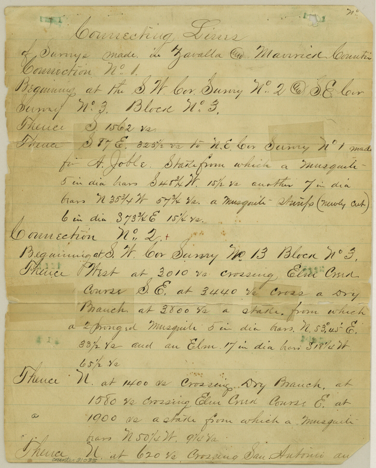
Maverick County Sketch File 3a
[Certified copy of field notes showing the connecting lines of I. & G. N. R.R. Co. surveys in Zavala and Maverick Counties]
-
Map/Doc
31035
-
Collection
General Map Collection
-
Object Dates
12/18/1875 (File Date)
-
People and Organizations
F.M. Maddox (Surveyor/Engineer)
-
Counties
Maverick Zavala
-
Subjects
Surveying Sketch File
-
Height x Width
10.0 x 8.0 inches
25.4 x 20.3 cm
-
Medium
paper, manuscript
-
Features
Dry Branch Creek
Elm Creek
San Antonio and Eagle Pass Road
Las Mores Creek
Rio Grande
Canyon Grande
Saus Creek
Eagle Pass and Pendencia Road
Comanche Creek
Dry Slough
Salado Creek
Part of: General Map Collection
Proposed bombing and machine gun restricted areas along Gulf of Mexico from San Luis Pass to Aransas Pass

Print $20.00
- Digital $50.00
Proposed bombing and machine gun restricted areas along Gulf of Mexico from San Luis Pass to Aransas Pass
1941
Size 11.1 x 24.1 inches
Map/Doc 3024
Plat of a survey of the North part of section 16, Block 362, Martha McBride, Presidio County, Texas

Print $6.00
- Digital $50.00
Plat of a survey of the North part of section 16, Block 362, Martha McBride, Presidio County, Texas
1989
Size 25.5 x 35.0 inches
Map/Doc 60521
A Map of the British Empire in America with the French and Spanish Settlements adjacent thereto

Print $20.00
- Digital $50.00
A Map of the British Empire in America with the French and Spanish Settlements adjacent thereto
Size 20.7 x 20.6 inches
Map/Doc 95704
Starr County Working Sketch 20

Print $20.00
- Digital $50.00
Starr County Working Sketch 20
1982
Size 29.5 x 35.2 inches
Map/Doc 63936
Chambers County NRC Article 33.136 Sketch 4

Print $48.00
- Digital $50.00
Chambers County NRC Article 33.136 Sketch 4
2003
Size 18.2 x 24.3 inches
Map/Doc 78569
Atascosa County Working Sketch 3

Print $20.00
- Digital $50.00
Atascosa County Working Sketch 3
1912
Size 26.3 x 13.2 inches
Map/Doc 67198
Flight Mission No. DQN-1K, Frame 146, Calhoun County

Print $20.00
- Digital $50.00
Flight Mission No. DQN-1K, Frame 146, Calhoun County
1953
Size 18.7 x 22.3 inches
Map/Doc 84209
Upton County Sketch File 25

Print $20.00
- Digital $50.00
Upton County Sketch File 25
1928
Size 27.1 x 44.4 inches
Map/Doc 10415
Presidio County Rolled Sketch 53

Print $20.00
- Digital $50.00
Presidio County Rolled Sketch 53
1911
Size 13.0 x 22.2 inches
Map/Doc 7346
Dimmit County Working Sketch 38

Print $40.00
- Digital $50.00
Dimmit County Working Sketch 38
1966
Size 59.4 x 43.0 inches
Map/Doc 68699
Brooks County Sketch File 6

Print $12.00
- Digital $50.00
Brooks County Sketch File 6
1941
Size 13.2 x 8.3 inches
Map/Doc 16560
El Paso County Boundary File 21

Print $6.00
- Digital $50.00
El Paso County Boundary File 21
Size 15.1 x 9.5 inches
Map/Doc 53214
You may also like
Flight Mission No. DAG-14K, Frame 135, Matagorda County

Print $20.00
- Digital $50.00
Flight Mission No. DAG-14K, Frame 135, Matagorda County
1952
Size 17.7 x 17.5 inches
Map/Doc 86306
General Highway Map. Detail of Cities and Towns in Hutchinson County, Texas [Borger, Stinnett and vicinity]
![79530, General Highway Map. Detail of Cities and Towns in Hutchinson County, Texas [Borger, Stinnett and vicinity], Texas State Library and Archives](https://historictexasmaps.com/wmedia_w700/maps/79530.tif.jpg)
Print $20.00
General Highway Map. Detail of Cities and Towns in Hutchinson County, Texas [Borger, Stinnett and vicinity]
1961
Size 24.6 x 18.3 inches
Map/Doc 79530
Flight Mission No. DIX-6P, Frame 127, Aransas County

Print $20.00
- Digital $50.00
Flight Mission No. DIX-6P, Frame 127, Aransas County
1956
Size 19.1 x 23.0 inches
Map/Doc 83833


El Paso County Boundary File 7a

Print $20.00
- Digital $50.00
El Paso County Boundary File 7a
Size 14.2 x 8.3 inches
Map/Doc 53094
Liberty County Sketch File 49

Print $2.00
- Digital $50.00
Liberty County Sketch File 49
1857
Size 11.8 x 8.3 inches
Map/Doc 30013
Fractional Township No. 9 South Range No. 25 East of the Indian Meridian, Indian Territory

Print $20.00
- Digital $50.00
Fractional Township No. 9 South Range No. 25 East of the Indian Meridian, Indian Territory
1898
Size 19.2 x 24.3 inches
Map/Doc 75243
Webb County Working Sketch 86

Print $20.00
- Digital $50.00
Webb County Working Sketch 86
1981
Size 44.3 x 37.0 inches
Map/Doc 72453
[Canadian River North]
![91826, [Canadian River North], Twichell Survey Records](https://historictexasmaps.com/wmedia_w700/maps/91826-1.tif.jpg)
Print $3.00
- Digital $50.00
[Canadian River North]
Size 17.9 x 11.7 inches
Map/Doc 91826
Nueces County Sketch File 4

Print $4.00
- Digital $50.00
Nueces County Sketch File 4
1848
Size 10.1 x 8.0 inches
Map/Doc 32505
Brewster County Sketch File N-19

Print $40.00
- Digital $50.00
Brewster County Sketch File N-19
1946
Size 18.7 x 26.2 inches
Map/Doc 10966