Castro County Sketch File 4m
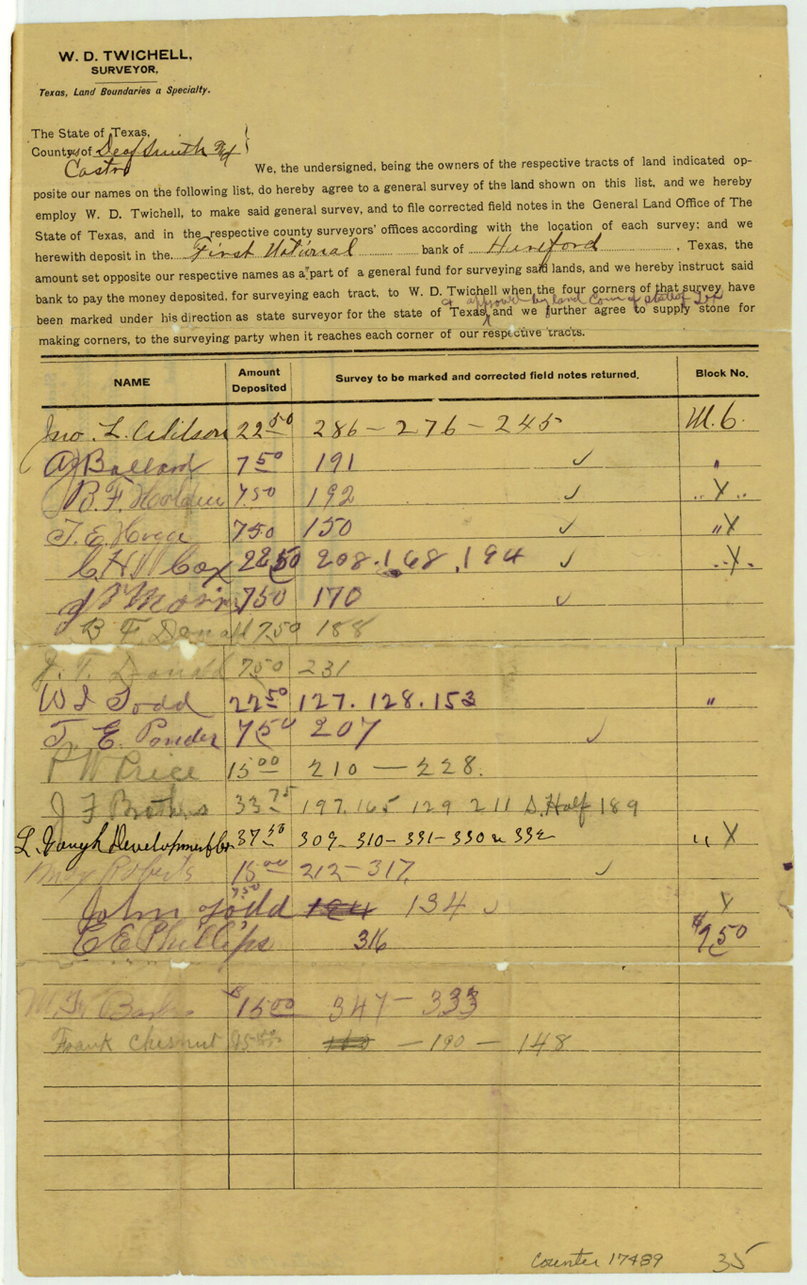
[Agreement for W.D. Twichell to survey mulitple sections within Block M6 in Deaf Smith and Castro Counties]
-
Map/Doc
17489
-
Collection
General Map Collection
-
People and Organizations
W.D. Twichell (Surveyor/Engineer)
-
Counties
Castro Deaf Smith Randall
-
Subjects
Surveying Sketch File
-
Height x Width
13.6 x 8.6 inches
34.5 x 21.8 cm
-
Medium
paper, print with manuscript additions
Part of: General Map Collection
Bexar County Sketch File 29

Print $40.00
- Digital $50.00
Bexar County Sketch File 29
Size 11.3 x 36.7 inches
Map/Doc 10919
Presidio County Rolled Sketch 102

Print $20.00
- Digital $50.00
Presidio County Rolled Sketch 102
1957
Size 22.8 x 17.4 inches
Map/Doc 7384
Young County Working Sketch 19

Print $20.00
- Digital $50.00
Young County Working Sketch 19
1961
Size 27.2 x 23.7 inches
Map/Doc 62042
Pecos County Rolled Sketch 82

Print $20.00
- Digital $50.00
Pecos County Rolled Sketch 82
1930
Size 28.3 x 25.8 inches
Map/Doc 10191
Newton County Rolled Sketch 27

Print $20.00
- Digital $50.00
Newton County Rolled Sketch 27
1961
Size 36.0 x 27.3 inches
Map/Doc 6856
Fannin County Working Sketch 9

Print $20.00
- Digital $50.00
Fannin County Working Sketch 9
1973
Size 28.1 x 21.9 inches
Map/Doc 69163
Kimble County Sketch File B

Print $22.00
- Digital $50.00
Kimble County Sketch File B
Size 14.3 x 12.7 inches
Map/Doc 28963
Glasscock County Working Sketch 12

Print $40.00
- Digital $50.00
Glasscock County Working Sketch 12
1971
Size 51.2 x 39.0 inches
Map/Doc 63185
Hale County Boundary File 4

Print $40.00
- Digital $50.00
Hale County Boundary File 4
Size 8.8 x 4.2 inches
Map/Doc 54048
Flight Mission No. BRE-2P, Frame 111, Nueces County

Print $20.00
- Digital $50.00
Flight Mission No. BRE-2P, Frame 111, Nueces County
1956
Size 18.4 x 22.6 inches
Map/Doc 86797
Matagorda County Sketch File 42a

Print $18.00
- Digital $50.00
Matagorda County Sketch File 42a
1914
Size 11.2 x 8.6 inches
Map/Doc 30853
Dallas County Sketch File 5

Print $18.00
- Digital $50.00
Dallas County Sketch File 5
1858
Size 10.5 x 8.4 inches
Map/Doc 20400
You may also like
Flight Mission No. DIX-8P, Frame 61, Aransas County

Print $20.00
- Digital $50.00
Flight Mission No. DIX-8P, Frame 61, Aransas County
1956
Size 18.8 x 22.6 inches
Map/Doc 83892
Map of Bee County State of Texas

Print $20.00
- Digital $50.00
Map of Bee County State of Texas
1863
Size 31.1 x 25.3 inches
Map/Doc 3286

Howard County Boundary File 1

Print $51.00
- Digital $50.00
Howard County Boundary File 1
Size 14.4 x 8.8 inches
Map/Doc 55086
Winkler County Sketch File 4

Print $8.00
- Digital $50.00
Winkler County Sketch File 4
Size 14.3 x 8.8 inches
Map/Doc 40463
[Jacob Masters league and those adjoining and Surveys on Elkhart Creek]
![183, [Jacob Masters league and those adjoining and Surveys on Elkhart Creek], General Map Collection](https://historictexasmaps.com/wmedia_w700/maps/183.tif.jpg)
Print $20.00
- Digital $50.00
[Jacob Masters league and those adjoining and Surveys on Elkhart Creek]
1846
Size 20.3 x 8.0 inches
Map/Doc 183
Upshur County Sketch File 11

Print $22.00
- Digital $50.00
Upshur County Sketch File 11
Size 8.4 x 10.4 inches
Map/Doc 38750
Stonewall County Rolled Sketch 11A

Print $20.00
- Digital $50.00
Stonewall County Rolled Sketch 11A
Size 33.4 x 28.2 inches
Map/Doc 7868
Flight Mission No. CRK-3P, Frame 174, Refugio County

Print $20.00
- Digital $50.00
Flight Mission No. CRK-3P, Frame 174, Refugio County
1956
Size 18.6 x 22.3 inches
Map/Doc 86921
Jasper County Sketch File 11

Print $5.00
- Digital $50.00
Jasper County Sketch File 11
Size 11.1 x 9.6 inches
Map/Doc 27790
Throckmorton County Rolled Sketch 3C

Print $20.00
- Digital $50.00
Throckmorton County Rolled Sketch 3C
Size 31.1 x 37.1 inches
Map/Doc 7989
Hutchinson County Working Sketch 46

Print $20.00
- Digital $50.00
Hutchinson County Working Sketch 46
1979
Size 20.4 x 22.3 inches
Map/Doc 66406