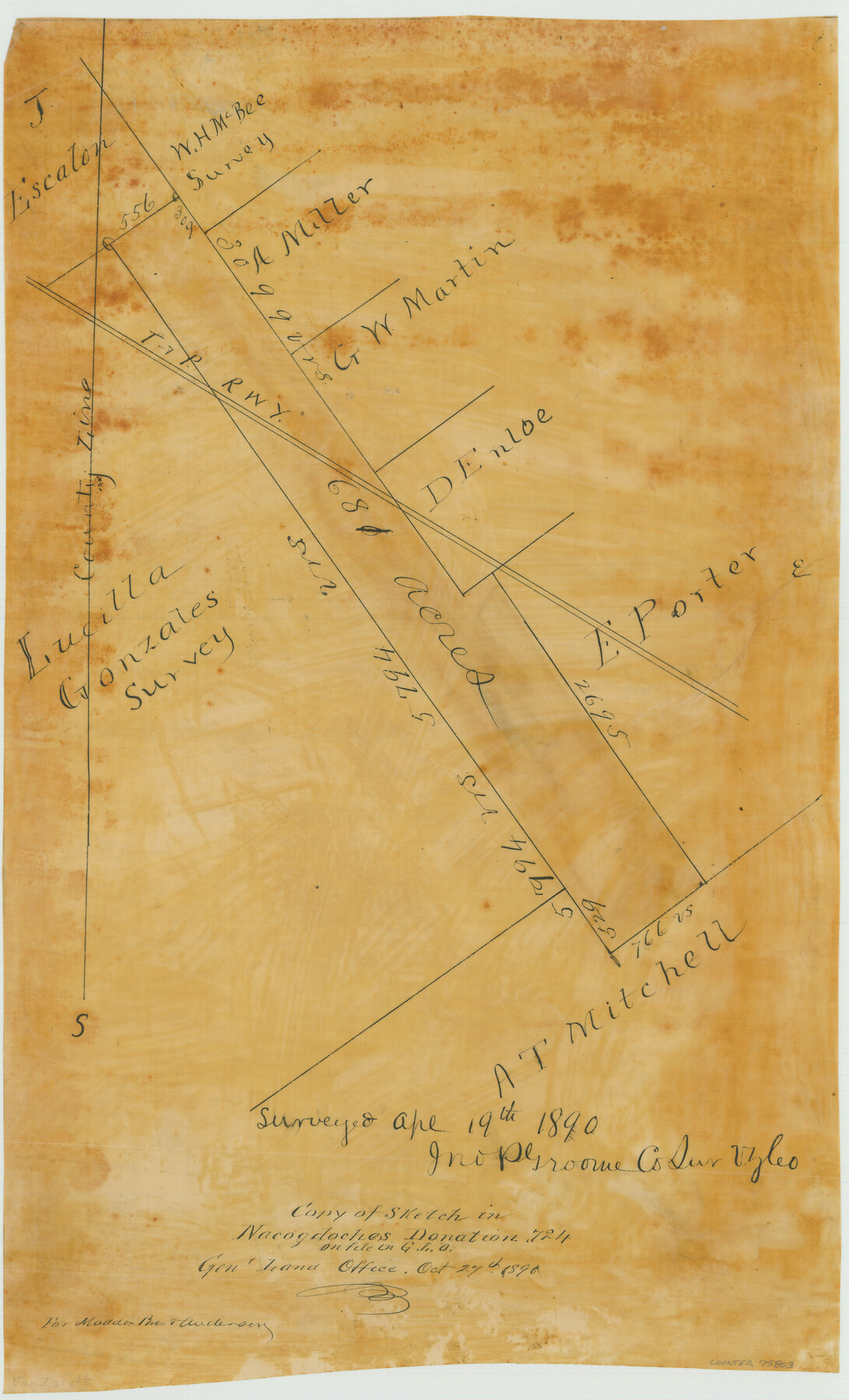
Copy of sketch in Nacogdoches Donation 724 on file in GLO
-
Map/Doc
75803
-
Collection
Maddox Collection
-
Object Dates
1890/10/27 (Creation Date)
1890/4/19 (Survey Date)
1890/10/27 (File Date)
-
People and Organizations
Jno. P. Groome (Surveyor/Engineer)
General Land Office (Author)
-
Counties
Van Zandt Kaufman
-
Subjects
County
-
Height x Width
18.0 x 10.9 inches
45.7 x 27.7 cm
-
Medium
linen, non-manuscript
-
Comments
Copied for Maddox Bros. & Anderson.
-
Features
T&P
Part of: Maddox Collection
[Sketch of surveys north of "Las Animas" grant, Webb County]
![668, [Sketch of surveys north of "Las Animas" grant, Webb County], Maddox Collection](https://historictexasmaps.com/wmedia_w700/maps/668.tif.jpg)
Print $3.00
- Digital $50.00
[Sketch of surveys north of "Las Animas" grant, Webb County]
1908
Size 16.9 x 10.7 inches
Map/Doc 668
Map of Brazoria County, Texas

Print $20.00
- Digital $50.00
Map of Brazoria County, Texas
1879
Size 28.0 x 26.5 inches
Map/Doc 589
Hall County, Texas

Print $20.00
- Digital $50.00
Hall County, Texas
1880
Size 24.9 x 20.4 inches
Map/Doc 480
Working Sketch Cottle County

Print $20.00
- Digital $50.00
Working Sketch Cottle County
1916
Size 31.7 x 29.6 inches
Map/Doc 4434
[Map of Townsite of Swearingen, Cottle County, Texas]
![4465, [Map of Townsite of Swearingen, Cottle County, Texas], Maddox Collection](https://historictexasmaps.com/wmedia_w700/maps/4465.tif.jpg)
Print $20.00
- Digital $50.00
[Map of Townsite of Swearingen, Cottle County, Texas]
Size 28.8 x 17.8 inches
Map/Doc 4465
San Patricio County, Texas

Print $20.00
- Digital $50.00
San Patricio County, Texas
1879
Size 18.1 x 22.8 inches
Map/Doc 611
Sketch of the Designation of Route of the Aransas Channel Harbor & Dock Company's Deep Water Channel

Print $3.00
- Digital $50.00
Sketch of the Designation of Route of the Aransas Channel Harbor & Dock Company's Deep Water Channel
Size 13.2 x 10.0 inches
Map/Doc 4495
Sketch of Garza Co.

Print $3.00
- Digital $50.00
Sketch of Garza Co.
1884
Size 12.3 x 10.2 inches
Map/Doc 468
Foard County, Texas

Print $20.00
- Digital $50.00
Foard County, Texas
1891
Size 19.5 x 20.7 inches
Map/Doc 727
Map of Duval County, Texas

Print $20.00
- Digital $50.00
Map of Duval County, Texas
1880
Size 29.8 x 22.6 inches
Map/Doc 712
[Sketch Showing Railroad land surveys in Dallam & Sherman Counties, Texas]
![75786, [Sketch Showing Railroad land surveys in Dallam & Sherman Counties, Texas], Maddox Collection](https://historictexasmaps.com/wmedia_w700/maps/75786.tif.jpg)
Print $20.00
- Digital $50.00
[Sketch Showing Railroad land surveys in Dallam & Sherman Counties, Texas]
Size 19.4 x 13.4 inches
Map/Doc 75786
Sketch H, Dickens County, Texas

Print $20.00
- Digital $50.00
Sketch H, Dickens County, Texas
1902
Size 16.0 x 14.3 inches
Map/Doc 4365
You may also like
Map showing connections and corners made on ground in south part of Yoakum County and north part of Gaines County, Texas

Print $20.00
- Digital $50.00
Map showing connections and corners made on ground in south part of Yoakum County and north part of Gaines County, Texas
1938
Size 43.7 x 36.5 inches
Map/Doc 93255
Maverick County Working Sketch 11

Print $20.00
- Digital $50.00
Maverick County Working Sketch 11
1965
Size 41.4 x 35.8 inches
Map/Doc 70903
Brooks County Boundary File Index

Print $2.00
- Digital $50.00
Brooks County Boundary File Index
Size 8.6 x 3.1 inches
Map/Doc 50808
Leon County Rolled Sketch 29

Print $20.00
- Digital $50.00
Leon County Rolled Sketch 29
1992
Size 34.6 x 32.9 inches
Map/Doc 6612
Galveston County Sketch File 68

Print $62.00
- Digital $50.00
Galveston County Sketch File 68
Size 4.4 x 9.7 inches
Map/Doc 23784
Val Verde County Working Sketch 51

Print $20.00
- Digital $50.00
Val Verde County Working Sketch 51
1952
Size 24.5 x 30.0 inches
Map/Doc 72186
Lubbock County Boundary File 1

Print $64.00
- Digital $50.00
Lubbock County Boundary File 1
Size 8.8 x 8.6 inches
Map/Doc 56455
[Map of the Stockdale-Cuero Extension G.H. & S.A. Ry.]
![64096, [Map of the Stockdale-Cuero Extension G.H. & S.A. Ry.], General Map Collection](https://historictexasmaps.com/wmedia_w700/maps/64096.tif.jpg)
Print $40.00
- Digital $50.00
[Map of the Stockdale-Cuero Extension G.H. & S.A. Ry.]
1905
Size 19.4 x 118.2 inches
Map/Doc 64096
Hartley County

Print $20.00
- Digital $50.00
Hartley County
1891
Size 25.9 x 27.8 inches
Map/Doc 3639
Wichita County Sketch File 25

Print $20.00
- Digital $50.00
Wichita County Sketch File 25
1919
Size 17.6 x 22.3 inches
Map/Doc 12685
Missouri, Kansas, and Texas Railway

Print $20.00
Missouri, Kansas, and Texas Railway
1878
Size 16.5 x 12.2 inches
Map/Doc 76188
Flight Mission No. CRK-5P, Frame 125, Refugio County

Print $20.00
- Digital $50.00
Flight Mission No. CRK-5P, Frame 125, Refugio County
1956
Size 18.3 x 22.3 inches
Map/Doc 86928