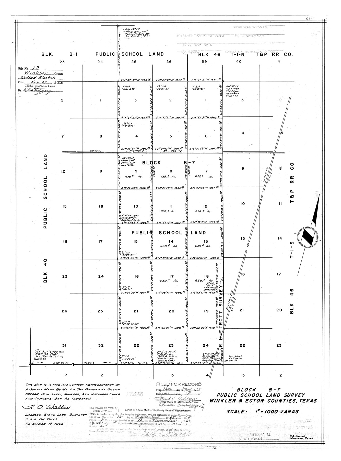
Winkler County Rolled Sketch 12
Block B-7 Public School Land survey, Winkler & Ector Counties, Texas
-
Map/Doc
8279
-
Collection
General Map Collection
-
Object Dates
1965/11/13 (Creation Date)
1965/11/27 (File Date)
-
People and Organizations
T.O. Wallis (Surveyor/Engineer)
-
Counties
Winkler Ector
-
Subjects
Surveying Rolled Sketch
-
Height x Width
24.9 x 18.5 inches
63.2 x 47.0 cm
-
Scale
1" = 1000 varas
Part of: General Map Collection
Crane County Sketch File 11

Print $40.00
- Digital $50.00
Crane County Sketch File 11
Size 18.5 x 8.9 inches
Map/Doc 19569
Hill County Sketch File 21a

Print $4.00
- Digital $50.00
Hill County Sketch File 21a
1887
Size 10.8 x 8.4 inches
Map/Doc 26503
Freestone County Sketch File 10

Print $40.00
- Digital $50.00
Freestone County Sketch File 10
Size 13.0 x 13.5 inches
Map/Doc 23058
Matagorda County Working Sketch Graphic Index, Sheet 1 (Sketches 1 to 16)

Print $40.00
- Digital $50.00
Matagorda County Working Sketch Graphic Index, Sheet 1 (Sketches 1 to 16)
1920
Size 40.0 x 48.8 inches
Map/Doc 76633
[Corpus Christi Bay, Padre Island, Mustang Island, Laguna de la Madre, King and Kenedy's Pasture]
![73043, [Corpus Christi Bay, Padre Island, Mustang Island, Laguna de la Madre, King and Kenedy's Pasture], General Map Collection](https://historictexasmaps.com/wmedia_w700/maps/73043.tif.jpg)
Print $20.00
- Digital $50.00
[Corpus Christi Bay, Padre Island, Mustang Island, Laguna de la Madre, King and Kenedy's Pasture]
Size 27.0 x 18.2 inches
Map/Doc 73043
Harris County Working Sketch 89

Print $20.00
- Digital $50.00
Harris County Working Sketch 89
1972
Size 37.3 x 39.0 inches
Map/Doc 65981
Pecos County Sketch File 41

Print $32.00
- Digital $50.00
Pecos County Sketch File 41
1919
Size 11.2 x 8.8 inches
Map/Doc 33729
Terrell County Working Sketch 78

Print $20.00
- Digital $50.00
Terrell County Working Sketch 78
1983
Size 41.0 x 37.2 inches
Map/Doc 69599
Guadalupe County Sketch File 7

Print $20.00
- Digital $50.00
Guadalupe County Sketch File 7
Size 15.6 x 19.5 inches
Map/Doc 11590
Aransas County Rolled Sketch 27C

Print $20.00
- Digital $50.00
Aransas County Rolled Sketch 27C
1979
Size 17.3 x 19.3 inches
Map/Doc 5056
Trinity River, Grapevine Sheet/Denton Creek

Print $6.00
- Digital $50.00
Trinity River, Grapevine Sheet/Denton Creek
1938
Size 22.2 x 34.7 inches
Map/Doc 65243
Leon County Sketch File 37

Print $90.00
- Digital $50.00
Leon County Sketch File 37
1965
Size 11.2 x 8.8 inches
Map/Doc 29853
You may also like
Irion County Sketch File 17

Print $20.00
- Digital $50.00
Irion County Sketch File 17
Size 26.7 x 40.5 inches
Map/Doc 10617
Map showing survey for proposed ship channel from Brownsville to Brazos Santiago Pass

Print $20.00
- Digital $50.00
Map showing survey for proposed ship channel from Brownsville to Brazos Santiago Pass
1912
Size 18.2 x 26.9 inches
Map/Doc 72898
Webb County Working Sketch 49

Print $20.00
- Digital $50.00
Webb County Working Sketch 49
1949
Size 22.7 x 27.8 inches
Map/Doc 72414
[South part Block AX and A21 and part of Block C44 and League 305]
![90798, [South part Block AX and A21 and part of Block C44 and League 305], Twichell Survey Records](https://historictexasmaps.com/wmedia_w700/maps/90798-1.tif.jpg)
Print $40.00
- Digital $50.00
[South part Block AX and A21 and part of Block C44 and League 305]
Size 49.3 x 23.5 inches
Map/Doc 90798
Harris County Working Sketch 59

Print $20.00
- Digital $50.00
Harris County Working Sketch 59
1953
Size 36.9 x 24.8 inches
Map/Doc 65951
Outer Continental Shelf Leasing Maps (Louisiana Offshore Operations)

Print $20.00
- Digital $50.00
Outer Continental Shelf Leasing Maps (Louisiana Offshore Operations)
1959
Size 13.7 x 17.4 inches
Map/Doc 76116
Map of The Surveyed Part of Peters Colony Texas

Print $40.00
- Digital $50.00
Map of The Surveyed Part of Peters Colony Texas
1852
Size 54.0 x 28.8 inches
Map/Doc 3155
East Part of West Bay and Southwest Part of Galveston Bay, Galveston County, showing Subdivision for Mineral Development

Print $40.00
- Digital $50.00
East Part of West Bay and Southwest Part of Galveston Bay, Galveston County, showing Subdivision for Mineral Development
1963
Size 42.2 x 58.2 inches
Map/Doc 1906
Houston County Sketch File 6a

Print $4.00
- Digital $50.00
Houston County Sketch File 6a
Size 10.2 x 8.1 inches
Map/Doc 26762
San Patricio County Sketch File 37

Print $94.00
- Digital $50.00
San Patricio County Sketch File 37
1915
Size 10.5 x 6.4 inches
Map/Doc 36142
Glasscock County Sketch File 4

Print $6.00
- Digital $50.00
Glasscock County Sketch File 4
Size 13.3 x 8.8 inches
Map/Doc 24161