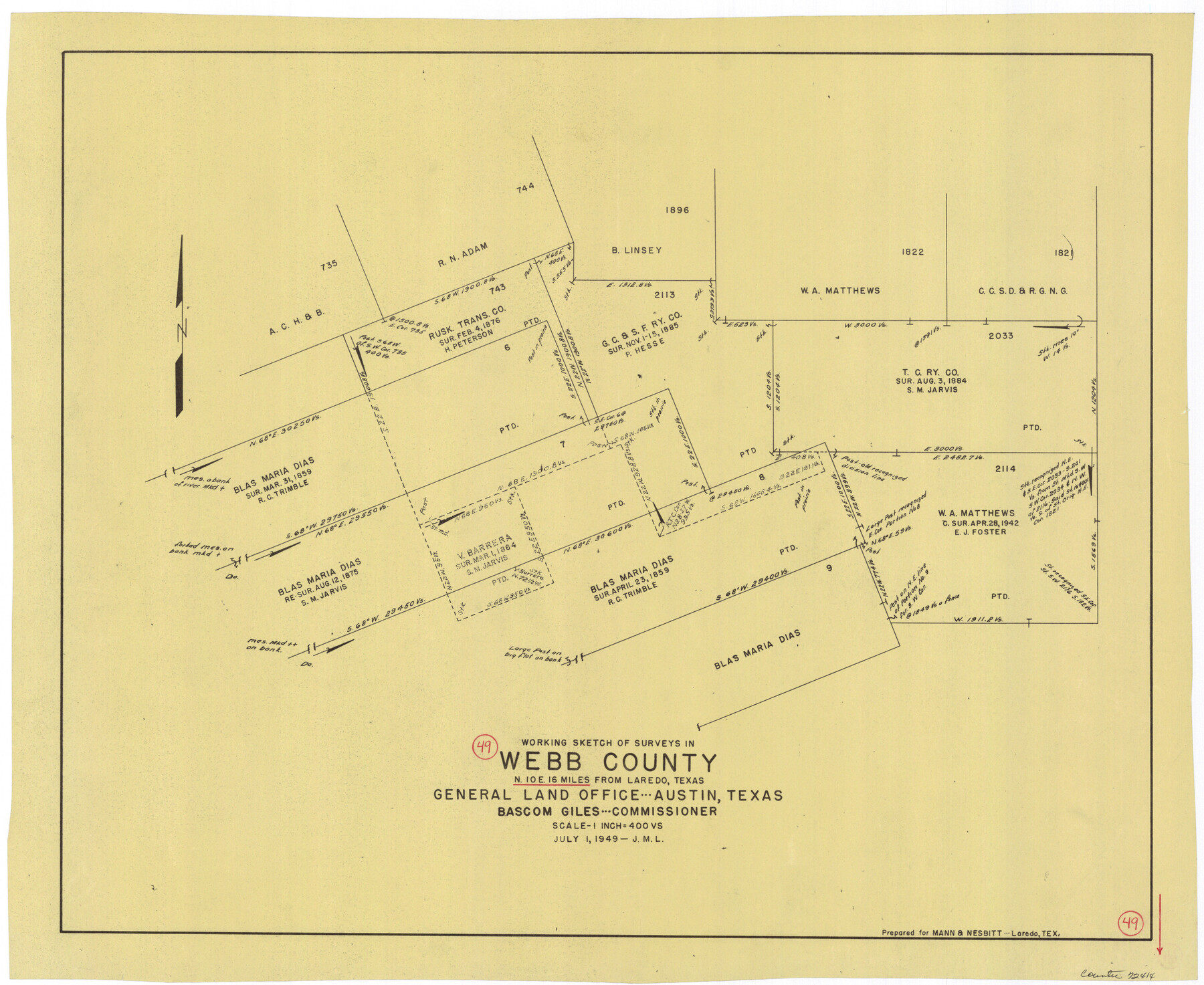
Webb County Working Sketch 49
-
Map/Doc
72414
-
Collection
General Map Collection
-
Object Dates
71/1949 (Creation Date)
-
Counties
Webb
-
Subjects
Surveying Working Sketch
-
Height x Width
22.7 x 27.8 inches
57.7 x 70.6 cm
-
Scale
1" = 400 varas
Part of: General Map Collection
Atlas Geográfico, Estadístico é Histórico de la República Mexicana

Atlas Geográfico, Estadístico é Histórico de la República Mexicana
Map/Doc 95689
Hall County Working Sketch 6

Print $20.00
- Digital $50.00
Hall County Working Sketch 6
1954
Size 21.8 x 21.6 inches
Map/Doc 63334
Crockett County Rolled Sketch 86

Print $20.00
- Digital $50.00
Crockett County Rolled Sketch 86
1947
Size 31.2 x 27.1 inches
Map/Doc 5626
Matagorda County NRC Article 33.136 Sketch 15

Print $42.00
- Digital $50.00
Matagorda County NRC Article 33.136 Sketch 15
Size 23.8 x 35.9 inches
Map/Doc 95739
Concho County Sketch File 29

Print $12.00
- Digital $50.00
Concho County Sketch File 29
1886
Size 11.7 x 9.0 inches
Map/Doc 19169
Burnet County Sketch File 3

Print $4.00
- Digital $50.00
Burnet County Sketch File 3
Size 12.3 x 8.1 inches
Map/Doc 16674
Terrell County Rolled Sketch 60

Print $20.00
- Digital $50.00
Terrell County Rolled Sketch 60
1998
Size 13.2 x 38.1 inches
Map/Doc 7976
Map Showing the Barranco Blanco, Rincon del Oso, and Rincon de Corpus Christi Grants

Print $40.00
- Digital $50.00
Map Showing the Barranco Blanco, Rincon del Oso, and Rincon de Corpus Christi Grants
1886
Size 58.8 x 80.1 inches
Map/Doc 16781
Tarrant County Sketch File 1a

Print $4.00
- Digital $50.00
Tarrant County Sketch File 1a
1851
Size 10.2 x 7.8 inches
Map/Doc 37670
Hudspeth County Rolled Sketch 43B

Print $20.00
- Digital $50.00
Hudspeth County Rolled Sketch 43B
1935
Size 11.0 x 17.3 inches
Map/Doc 6253
Polk County Working Sketch 13

Print $20.00
- Digital $50.00
Polk County Working Sketch 13
1942
Size 17.1 x 20.6 inches
Map/Doc 71628
Kimble County Rolled Sketch 33

Print $20.00
- Digital $50.00
Kimble County Rolled Sketch 33
1973
Size 26.7 x 20.1 inches
Map/Doc 6523
You may also like
Terlingua Special Map, The University of Texas Mineral Survey, Brewster County, Texas

Print $20.00
- Digital $50.00
Terlingua Special Map, The University of Texas Mineral Survey, Brewster County, Texas
1902
Size 20.4 x 22.6 inches
Map/Doc 482
Shelby County Sketch File 15

Print $6.00
- Digital $50.00
Shelby County Sketch File 15
1872
Size 10.2 x 15.5 inches
Map/Doc 36624
Baylor County Rolled Sketch 9

Print $20.00
- Digital $50.00
Baylor County Rolled Sketch 9
1892
Size 18.2 x 26.1 inches
Map/Doc 5125
Bailey County Rolled Sketch RSH

Print $20.00
- Digital $50.00
Bailey County Rolled Sketch RSH
1907
Size 34.3 x 23.3 inches
Map/Doc 5112
Randall County Sketch File 9

Print $22.00
- Digital $50.00
Randall County Sketch File 9
Size 13.9 x 17.0 inches
Map/Doc 34970
Parker County Sketch File 9

Print $4.00
- Digital $50.00
Parker County Sketch File 9
Size 8.1 x 10.0 inches
Map/Doc 33538
Fisher County Sketch File 5

Print $20.00
- Digital $50.00
Fisher County Sketch File 5
1887
Size 35.3 x 47.6 inches
Map/Doc 10449
Lynn County Boundary File 7

Print $10.00
- Digital $50.00
Lynn County Boundary File 7
Size 11.5 x 8.8 inches
Map/Doc 56642
Dallas County Sketch File 1

Print $4.00
- Digital $50.00
Dallas County Sketch File 1
1853
Size 7.2 x 7.0 inches
Map/Doc 20394
Intracoastal Waterway - Galveston Bay to West Bay including Galveston Bay Entrance

Print $20.00
- Digital $50.00
Intracoastal Waterway - Galveston Bay to West Bay including Galveston Bay Entrance
1962
Size 26.8 x 38.4 inches
Map/Doc 69937
Dimmit County Sketch File 22a

Print $2.00
- Digital $50.00
Dimmit County Sketch File 22a
Size 10.0 x 8.6 inches
Map/Doc 21132
Reeves County Rolled Sketch 33
Print $20.00
- Digital $50.00
Reeves County Rolled Sketch 33
Size 24.7 x 36.9 inches
Map/Doc 7501