Glasscock County Sketch File 4
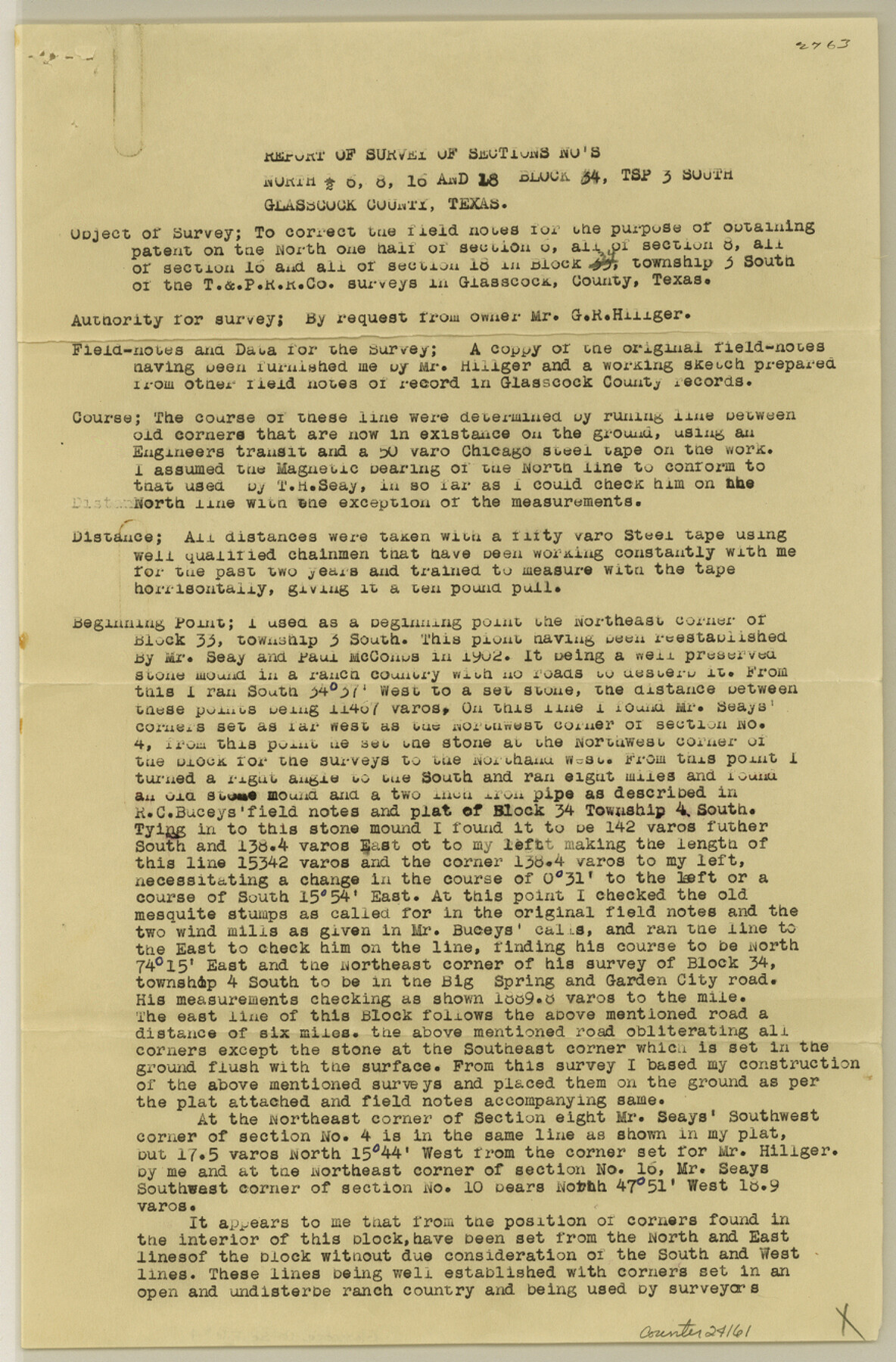
[Report of survey of north half of section 6, sections 8, 16 and 18, Block 34, Township 3 South]
- 
                          Map/Doc
24161
 - 
                            Collection
General Map Collection
 - 
                            Object Dates
1930/9/16 (File Date)
1902 (Survey Date)
 - 
                            People and Organizations
R.E. Morris (Surveyor/Engineer)
T.H. Seay (Surveyor/Engineer)
Paul McCombs (Surveyor/Engineer)
R.C. Bucey (Surveyor/Engineer)
 - 
                            Counties
Glasscock
 - 
                            Subjects
Surveying Sketch File
 - 
                            Height x Width
13.3 x 8.8 inches
33.8 x 22.4 cm
 - 
                            Medium
paper, print
 - 
                            Features
Big Spring and Garden City Road
Big Spring Road
Garden City Road
 
Part of: General Map Collection
            Camp County Working Sketch 2


                                            Print $20.00                    
                                             -                         Digital $50.00                                    
                Camp County Working Sketch 2
1975
Size 24.8 x 24.5 inches
                                Map/Doc 67878
            
            Galveston County NRC Article 33.136 Sketch 17


                                            Print $22.00                    
                                             -                         Digital $50.00                                    
                Galveston County NRC Article 33.136 Sketch 17
2002
Size 24.1 x 36.4 inches
                                Map/Doc 78584
            
            Austin Street Map & Guide


                                                                    Digital $50.00                                    
                Austin Street Map & Guide
Size 35.4 x 23.1 inches
                                Map/Doc 94435
            
            Bandera County Working Sketch 46


                                            Print $20.00                    
                                             -                         Digital $50.00                                    
                Bandera County Working Sketch 46
1981
Size 28.0 x 37.4 inches
                                Map/Doc 67642
            
            Potter County Working Sketch 11


                                            Print $20.00                    
                                             -                         Digital $50.00                                    
                Potter County Working Sketch 11
1972
Size 27.4 x 26.4 inches
                                Map/Doc 71671
            
            Map of Nacogdoches County


                                            Print $20.00                    
                                             -                         Digital $50.00                                    
                Map of Nacogdoches County
1857
Size 22.9 x 24.3 inches
                                Map/Doc 3907
            
            Loving County Rolled Sketch 15


                                            Print $20.00                    
                                             -                         Digital $50.00                                    
                Loving County Rolled Sketch 15
2015
Size 36.2 x 24.4 inches
                                Map/Doc 93793
            
            Angelina County Boundary File 1


                                            Print $16.00                    
                                             -                         Digital $50.00                                    
                Angelina County Boundary File 1
Size 12.9 x 8.3 inches
                                Map/Doc 49765
            
            Flight Mission No. DQN-3K, Frame 32, Calhoun County


                                            Print $20.00                    
                                             -                         Digital $50.00                                    
                Flight Mission No. DQN-3K, Frame 32, Calhoun County
1953
Size 18.6 x 22.3 inches
                                Map/Doc 84345
            
            Proceedings of The International (Water) Boundary Commission United States and Mexico Treaties of 1884 and 1889, Volume 1


            Proceedings of The International (Water) Boundary Commission United States and Mexico Treaties of 1884 and 1889, Volume 1
Map/Doc 83144
            
            [Surveys in the Jefferson District on the Sabine River]


                                            Print $2.00                    
                                             -                         Digital $50.00                                    
                [Surveys in the Jefferson District on the Sabine River]
1841
Size 8.7 x 7.8 inches
                                Map/Doc 325
            
            Hardeman County Working Sketch 15


                                            Print $40.00                    
                                             -                         Digital $50.00                                    
                Hardeman County Working Sketch 15
1981
Size 42.9 x 49.1 inches
                                Map/Doc 63396
            You may also like
            Briscoe County Sketch File L


                                            Print $40.00                    
                                             -                         Digital $50.00                                    
                Briscoe County Sketch File L
1935
Size 30.4 x 27.4 inches
                                Map/Doc 11009
            
            Duval County Working Sketch 11


                                            Print $20.00                    
                                             -                         Digital $50.00                                    
                Duval County Working Sketch 11
1937
Size 24.3 x 19.4 inches
                                Map/Doc 68724
            
            Archer County Sketch File 16


                                            Print $6.00                    
                                             -                         Digital $50.00                                    
                Archer County Sketch File 16
1889
Size 12.8 x 8.3 inches
                                Map/Doc 13650
            
            The Judicial District/County of Burleson. Created, January 15, 1842


                                            Print $20.00                    
                                    
                The Judicial District/County of Burleson. Created, January 15, 1842
2020
Size 14.1 x 21.7 inches
                                Map/Doc 96320
            
            [Right of Way & Track Map, The Texas & Pacific Ry. Co. Main Line]


                                            Print $20.00                    
                                             -                         Digital $50.00                                    
                [Right of Way & Track Map, The Texas & Pacific Ry. Co. Main Line]
Size 11.0 x 19.0 inches
                                Map/Doc 64689
            
            La Salle County Rolled Sketch 28


                                            Print $90.00                    
                                             -                         Digital $50.00                                    
                La Salle County Rolled Sketch 28
1956
Size 51.1 x 49.1 inches
                                Map/Doc 9561
            
            Wharton County Working Sketch 23


                                            Print $20.00                    
                                             -                         Digital $50.00                                    
                Wharton County Working Sketch 23
1919
Size 22.0 x 36.0 inches
                                Map/Doc 72487
            
            Ward County Rolled Sketch 29


                                            Print $20.00                    
                                             -                         Digital $50.00                                    
                Ward County Rolled Sketch 29
Size 31.8 x 27.4 inches
                                Map/Doc 89287
            
            Fort Bend County State Real Property Sketch 9


                                            Print $40.00                    
                                             -                         Digital $50.00                                    
                Fort Bend County State Real Property Sketch 9
1986
Size 34.7 x 43.2 inches
                                Map/Doc 61683
            
            Map of Limestone County


                                            Print $20.00                    
                                             -                         Digital $50.00                                    
                Map of Limestone County
1877
Size 24.1 x 26.9 inches
                                Map/Doc 83012
            
            Travis County Sketch File 8


                                            Print $4.00                    
                                             -                         Digital $50.00                                    
                Travis County Sketch File 8
Size 10.2 x 8.1 inches
                                Map/Doc 38288