Aransas County Rolled Sketch 27C
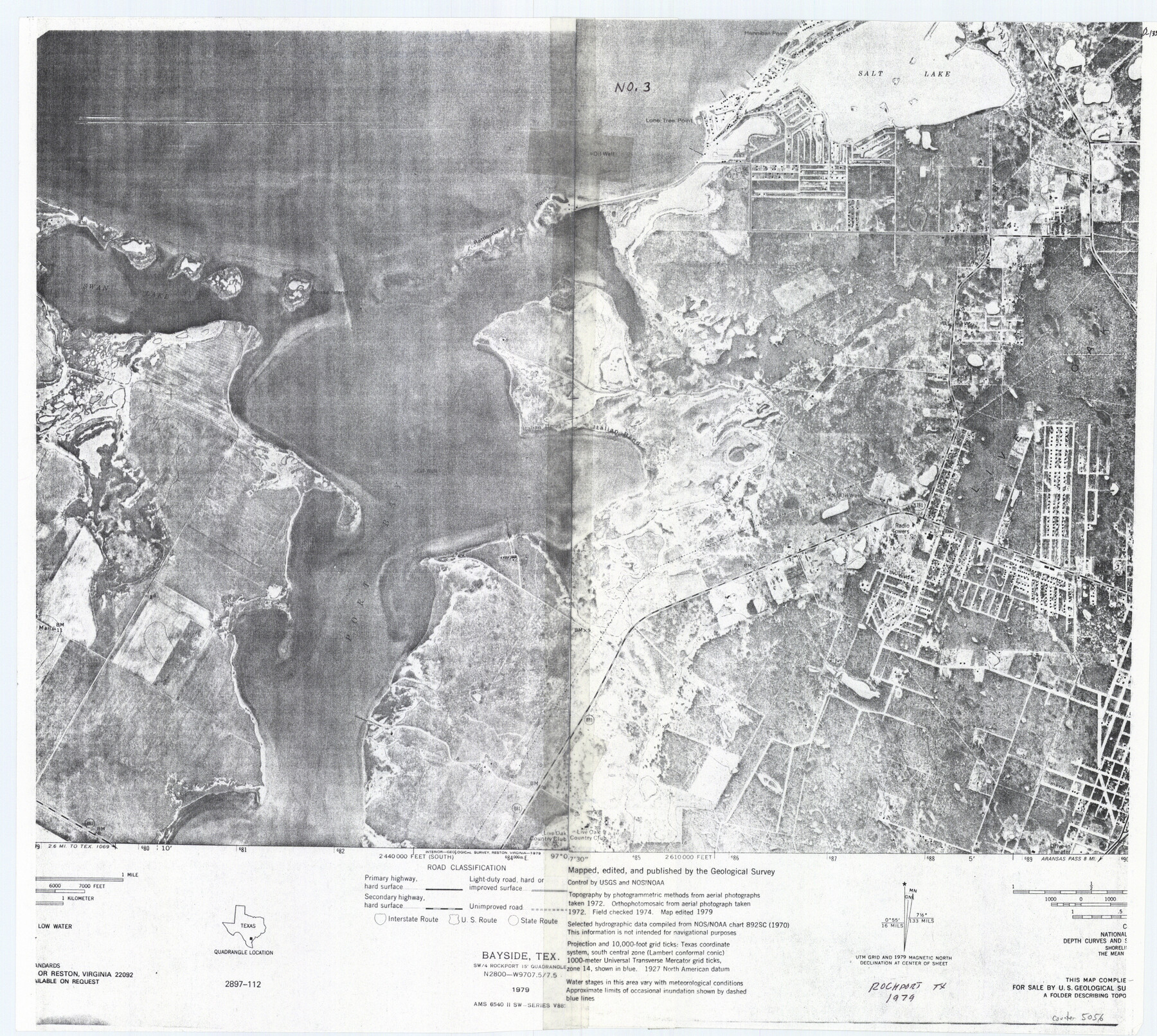
[1979 Orthophotomosaic from aerial photograph, partial Bayside, Tex. USGS quad]
-
Map/Doc
5056
-
Collection
General Map Collection
-
Object Dates
1979 (Creation Date)
1983/10/6 (File Date)
-
Counties
Aransas
-
Subjects
Aerial Photograph Surveying Rolled Sketch
-
Height x Width
17.3 x 19.3 inches
43.9 x 49.0 cm
-
Comments
See Aransas County Rolled Sketches 27 (5059), 27A (5058), 27B (5057), 27D (8418), 27E (8419), and 27G (8421) for related sketch and other aerial photographs.
Related maps
Aransas County Rolled Sketch 27B

Print $2.00
- Digital $50.00
Aransas County Rolled Sketch 27B
1958
Size 9.1 x 9.1 inches
Map/Doc 5057
Aransas County Rolled Sketch 27A

Print $2.00
- Digital $50.00
Aransas County Rolled Sketch 27A
1930
Size 8.9 x 7.2 inches
Map/Doc 5058
Aransas County Rolled Sketch 27

Print $20.00
- Digital $50.00
Aransas County Rolled Sketch 27
1983
Size 24.9 x 35.4 inches
Map/Doc 5059
Aransas County Rolled Sketch 27D

Print $20.00
- Digital $50.00
Aransas County Rolled Sketch 27D
1930
Size 40.5 x 40.2 inches
Map/Doc 8418
Aransas County Rolled Sketch 27E

Print $20.00
- Digital $50.00
Aransas County Rolled Sketch 27E
1958
Size 30.2 x 30.9 inches
Map/Doc 8419
Aransas County Rolled Sketch 27G

Print $20.00
- Digital $50.00
Aransas County Rolled Sketch 27G
1983
Size 32.8 x 33.0 inches
Map/Doc 8421
Part of: General Map Collection
DeWitt County Working Sketch 8

Print $20.00
- Digital $50.00
DeWitt County Working Sketch 8
1979
Size 35.7 x 41.9 inches
Map/Doc 68598
Childress County Sketch File 16a

Print $16.00
- Digital $50.00
Childress County Sketch File 16a
1901
Size 13.3 x 8.3 inches
Map/Doc 18309
Flight Mission No. DCL-4C, Frame 121, Kenedy County

Print $20.00
- Digital $50.00
Flight Mission No. DCL-4C, Frame 121, Kenedy County
1943
Size 18.6 x 22.3 inches
Map/Doc 85820
Eastland County Working Sketch 5

Print $20.00
- Digital $50.00
Eastland County Working Sketch 5
1918
Size 16.1 x 19.3 inches
Map/Doc 68786
Medina County Rolled Sketch 13

Print $20.00
- Digital $50.00
Medina County Rolled Sketch 13
1979
Size 28.2 x 18.3 inches
Map/Doc 6747
Hill County Sketch File 22

Print $8.00
- Digital $50.00
Hill County Sketch File 22
1860
Size 7.7 x 8.2 inches
Map/Doc 26505
Map of Copano, St. Charles, Aransas & Red Fish Bays in Aransas & Nueces Counties showing subdivision thereof for Mineral Development

Print $20.00
- Digital $50.00
Map of Copano, St. Charles, Aransas & Red Fish Bays in Aransas & Nueces Counties showing subdivision thereof for Mineral Development
1948
Size 35.9 x 34.0 inches
Map/Doc 2923
Plano General de la Ciudad de Mexico. Levantado Por el Teniente Coronel Don Diego Garcia Conde en el Año de 1793. Aumentado y corregido en lo mas notable Por el Teniente Coronel retirado, Don Rafael Maria Calvo En el de 1830

Print $20.00
- Digital $50.00
Plano General de la Ciudad de Mexico. Levantado Por el Teniente Coronel Don Diego Garcia Conde en el Año de 1793. Aumentado y corregido en lo mas notable Por el Teniente Coronel retirado, Don Rafael Maria Calvo En el de 1830
1793
Size 19.7 x 21.8 inches
Map/Doc 95354
Presidio County Rolled Sketch 145

Print $20.00
- Digital $50.00
Presidio County Rolled Sketch 145
2012
Size 36.6 x 24.5 inches
Map/Doc 93380
Ector County Working Sketch 32

Print $20.00
- Digital $50.00
Ector County Working Sketch 32
1981
Size 26.2 x 17.0 inches
Map/Doc 68875
Castro County Sketch File 4

Print $6.00
- Digital $50.00
Castro County Sketch File 4
1908
Size 6.9 x 8.9 inches
Map/Doc 17462
Van Zandt County Working Sketch Graphic Index

Print $20.00
- Digital $50.00
Van Zandt County Working Sketch Graphic Index
1972
Size 46.2 x 40.7 inches
Map/Doc 76727
You may also like
Walker County Sketch File 1

Print $4.00
- Digital $50.00
Walker County Sketch File 1
1853
Size 9.7 x 8.3 inches
Map/Doc 39547
Briscoe County Sketch File D-2

Print $40.00
- Digital $50.00
Briscoe County Sketch File D-2
1901
Size 18.5 x 7.8 inches
Map/Doc 16411
Presidio County Working Sketch 97

Print $20.00
- Digital $50.00
Presidio County Working Sketch 97
1978
Size 28.2 x 28.0 inches
Map/Doc 71774
Throckmorton County Sketch File 13

Print $20.00
- Digital $50.00
Throckmorton County Sketch File 13
1994
Size 11.3 x 9.1 inches
Map/Doc 38120
Flight Mission No. DAG-18K, Frame 76, Matagorda County

Print $20.00
- Digital $50.00
Flight Mission No. DAG-18K, Frame 76, Matagorda County
1952
Size 17.5 x 22.1 inches
Map/Doc 86369
Polk County Working Sketch 8

Print $20.00
- Digital $50.00
Polk County Working Sketch 8
1934
Size 24.2 x 30.5 inches
Map/Doc 71623
S.P.O. Co. No. 7, State Submerged Tract No. 12, Laguna Madre, Nueces Co., Texas

Print $20.00
- Digital $50.00
S.P.O. Co. No. 7, State Submerged Tract No. 12, Laguna Madre, Nueces Co., Texas
1937
Size 27.9 x 27.4 inches
Map/Doc 3026
Topographical Map of the Rio Grande, Sheet No. 17

Print $20.00
- Digital $50.00
Topographical Map of the Rio Grande, Sheet No. 17
1912
Map/Doc 89541
Map of Cooke County originally Fannin Land District

Print $20.00
- Digital $50.00
Map of Cooke County originally Fannin Land District
1858
Size 25.4 x 18.9 inches
Map/Doc 950
Working Sketch in Gray, Donley, and Carson Counties, Texas

Print $20.00
- Digital $50.00
Working Sketch in Gray, Donley, and Carson Counties, Texas
1909
Size 22.7 x 27.0 inches
Map/Doc 90779

Maps of Gulf Intracoastal Waterway, Texas - Sabine River to the Rio Grande and connecting waterways including ship channels

Print $20.00
- Digital $50.00
Maps of Gulf Intracoastal Waterway, Texas - Sabine River to the Rio Grande and connecting waterways including ship channels
1966
Size 14.5 x 22.3 inches
Map/Doc 61944