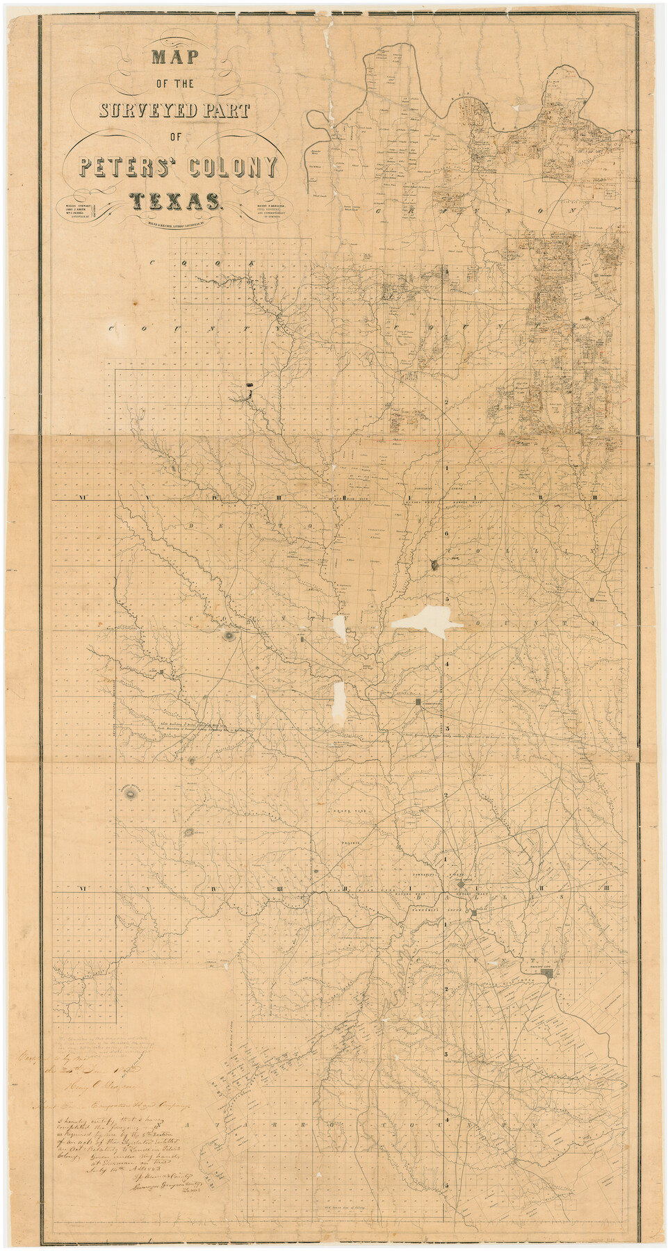
Map of The Surveyed Part of Peters Colony Texas
K-5-46
-
Map/Doc
3155
-
Collection
General Map Collection
-
Object Dates
1852 (Creation Date)
-
People and Organizations
Milne and Bruder Lithographers (Printer)
Henry O. Hedgcoxe (Author)
-
Counties
Collin Cooke Dallas Denton Grayson Tarrant
-
Subjects
Colony
-
Height x Width
54.0 x 28.8 inches
137.2 x 73.2 cm
-
Comments
Certified on June 24, 1852 by Henry O. Hedgcoxe, Agent of the Texas Emigration Land Company.
Conservation funded in 2002 with donations from Farmers Branch Historical Park.
Part of: General Map Collection
Chambers County Sketch File 47

Print $211.00
- Digital $50.00
Chambers County Sketch File 47
1927
Size 14.3 x 9.0 inches
Map/Doc 17899
Red River Co.

Print $40.00
- Digital $50.00
Red River Co.
1897
Size 48.0 x 39.4 inches
Map/Doc 66993
Hill County Sketch File 1

Print $4.00
- Digital $50.00
Hill County Sketch File 1
1857
Size 9.0 x 7.9 inches
Map/Doc 26459
Kimble County Sketch File 9a

Print $4.00
- Digital $50.00
Kimble County Sketch File 9a
Size 12.4 x 9.2 inches
Map/Doc 28929
Hudspeth County Working Sketch 52

Print $20.00
- Digital $50.00
Hudspeth County Working Sketch 52
1985
Size 29.8 x 36.6 inches
Map/Doc 66337
Travis County Sketch File 6

Print $8.00
- Digital $50.00
Travis County Sketch File 6
1841
Size 13.8 x 10.9 inches
Map/Doc 38283
G.C. & S.F. Ry. Alinement and Right of Way map of Dallas Branch, Ellis County, Texas

Print $40.00
- Digital $50.00
G.C. & S.F. Ry. Alinement and Right of Way map of Dallas Branch, Ellis County, Texas
1925
Size 31.4 x 120.7 inches
Map/Doc 64547
Culberson County Working Sketch 2

Print $20.00
- Digital $50.00
Culberson County Working Sketch 2
Size 27.7 x 18.7 inches
Map/Doc 68454
Val Verde County Rolled Sketch 30

Print $20.00
- Digital $50.00
Val Verde County Rolled Sketch 30
1884
Size 43.8 x 26.4 inches
Map/Doc 8111
Map of Chocolate Bay, west portion of West Bay & vicinity, Brazoria & Galveston Counties showing subdivision for mineral development

Print $40.00
- Digital $50.00
Map of Chocolate Bay, west portion of West Bay & vicinity, Brazoria & Galveston Counties showing subdivision for mineral development
1948
Size 42.2 x 55.2 inches
Map/Doc 2974
Shelby County Working Sketch 30

Print $20.00
- Digital $50.00
Shelby County Working Sketch 30
Size 35.9 x 44.7 inches
Map/Doc 63885
Concho County Working Sketch 6
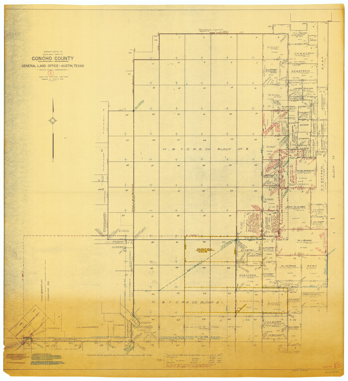
Print $20.00
- Digital $50.00
Concho County Working Sketch 6
1948
Size 47.3 x 43.2 inches
Map/Doc 68188
You may also like
Grayson County Sketch File 13

Print $40.00
- Digital $50.00
Grayson County Sketch File 13
1853
Size 16.2 x 14.4 inches
Map/Doc 24480
Terrell County Working Sketch 7

Print $20.00
- Digital $50.00
Terrell County Working Sketch 7
Size 42.2 x 31.3 inches
Map/Doc 62156
Rusk County Sketch File 39

Print $6.00
Rusk County Sketch File 39
1951
Size 11.3 x 8.9 inches
Map/Doc 35579
Jeff Davis County Sketch File 43

Print $10.00
- Digital $50.00
Jeff Davis County Sketch File 43
1970
Size 14.2 x 8.6 inches
Map/Doc 28066
Travis County Working Sketch 30

Print $6.00
- Digital $50.00
Travis County Working Sketch 30
Size 30.5 x 35.1 inches
Map/Doc 69414
Pecos County Working Sketch 61

Print $20.00
- Digital $50.00
Pecos County Working Sketch 61
1952
Size 28.4 x 22.7 inches
Map/Doc 71533
Foard County Sketch File 26

Print $40.00
- Digital $50.00
Foard County Sketch File 26
Size 13.5 x 17.7 inches
Map/Doc 22856
Victoria County Sketch File 4

Print $7.00
- Digital $50.00
Victoria County Sketch File 4
1876
Size 10.1 x 8.2 inches
Map/Doc 39517
Fisher County Sketch File 20

Print $66.00
- Digital $50.00
Fisher County Sketch File 20
Size 9.3 x 9.1 inches
Map/Doc 22616
McKinney Bayou Sheet, Bowie County, Red River

Print $20.00
- Digital $50.00
McKinney Bayou Sheet, Bowie County, Red River
1933
Size 37.1 x 33.5 inches
Map/Doc 75272
Map of section no. 7 of a survey of Padre Island made for the Office of the Attorney General of the State of Texas

Print $40.00
- Digital $50.00
Map of section no. 7 of a survey of Padre Island made for the Office of the Attorney General of the State of Texas
1941
Size 56.3 x 41.2 inches
Map/Doc 2263
Clarke and Courts' Map of Jefferson County and Beaumont and Sour Lake Oil Fields

Print $20.00
Clarke and Courts' Map of Jefferson County and Beaumont and Sour Lake Oil Fields
1901
Size 28.2 x 24.3 inches
Map/Doc 79289