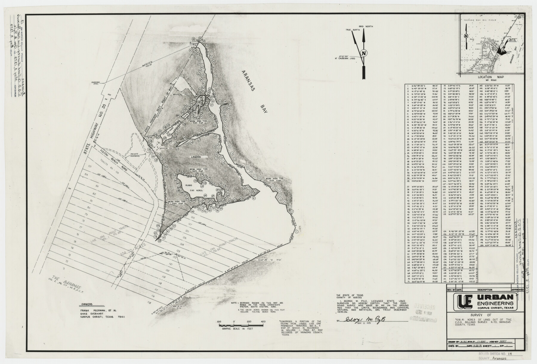
Aransas County Rolled Sketch 19
Survey of 108.41 acres of land out of the C.O.D. Gilland survey A-70, Aransas County, Texas
-
Map/Doc
82559
-
Collection
General Map Collection
-
Object Dates
1979/4/25 (Creation Date)
1979/5/9 (File Date)
-
People and Organizations
George M. Pyle (Surveyor/Engineer)
Frank Peerman (Landowner)
-
Counties
Aransas
-
Subjects
Surveying Rolled Sketch
-
Height x Width
24.8 x 36.7 inches
63.0 x 93.2 cm
-
Medium
mylar, print
-
Scale
1" = 200'
-
Comments
See Aransas County Rolled Sketches 19A (76068), 19B (76077), and 19C (5063).
Related maps
Aransas County Rolled Sketch 19C

Print $20.00
- Digital $50.00
Aransas County Rolled Sketch 19C
Size 40.9 x 30.6 inches
Map/Doc 5063
Aransas County Rolled Sketch 19A

Print $20.00
- Digital $50.00
Aransas County Rolled Sketch 19A
1979
Size 32.0 x 24.8 inches
Map/Doc 76068
Aransas County Rolled Sketch 19B

Print $20.00
- Digital $50.00
Aransas County Rolled Sketch 19B
1979
Size 25.7 x 18.7 inches
Map/Doc 76077
Part of: General Map Collection
Flight Mission No. DQO-2K, Frame 92, Galveston County

Print $20.00
- Digital $50.00
Flight Mission No. DQO-2K, Frame 92, Galveston County
1952
Size 18.8 x 22.5 inches
Map/Doc 85019
Sabine County Working Sketch 7

Print $20.00
- Digital $50.00
Sabine County Working Sketch 7
1922
Size 15.3 x 19.4 inches
Map/Doc 63678
Uvalde County Sketch File 30

Print $12.00
- Digital $50.00
Uvalde County Sketch File 30
1990
Size 4.4 x 9.9 inches
Map/Doc 39032
Howard County Working Sketch 2

Print $20.00
- Digital $50.00
Howard County Working Sketch 2
1903
Size 21.7 x 20.9 inches
Map/Doc 66268
Morris County Rolled Sketch 2A

Print $20.00
- Digital $50.00
Morris County Rolled Sketch 2A
Size 24.1 x 18.9 inches
Map/Doc 10278
Sherman County Rolled Sketch 5

Print $20.00
- Digital $50.00
Sherman County Rolled Sketch 5
1919
Size 36.9 x 41.4 inches
Map/Doc 9928
Terrell County Working Sketch 72

Print $20.00
- Digital $50.00
Terrell County Working Sketch 72
1980
Size 14.3 x 24.8 inches
Map/Doc 69593
Fractional Township No. 8 South Range No. 13 East of the Indian Meridian, Indian Territory

Print $20.00
- Digital $50.00
Fractional Township No. 8 South Range No. 13 East of the Indian Meridian, Indian Territory
1896
Size 19.1 x 24.3 inches
Map/Doc 75224
Galveston County

Print $40.00
- Digital $50.00
Galveston County
1939
Size 44.6 x 59.1 inches
Map/Doc 66835
Reeves County Working Sketch 12

Print $20.00
- Digital $50.00
Reeves County Working Sketch 12
1958
Size 34.2 x 24.5 inches
Map/Doc 63455
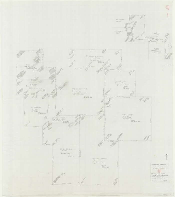
Cass County Working Sketch 50
Print $20.00
- Digital $50.00
Cass County Working Sketch 50
Size 42.6 x 37.7 inches
Map/Doc 67953
Jim Hogg County Sketch File 9

Print $24.00
- Digital $50.00
Jim Hogg County Sketch File 9
1941
Size 14.2 x 8.7 inches
Map/Doc 28411
You may also like
Colorado River, Bay City to Matagorda Sheet 2

Print $40.00
- Digital $50.00
Colorado River, Bay City to Matagorda Sheet 2
1924
Size 86.2 x 32.8 inches
Map/Doc 65260
Presidio County Rolled Sketch 131A

Print $20.00
- Digital $50.00
Presidio County Rolled Sketch 131A
Size 25.5 x 26.3 inches
Map/Doc 10712
Harrison County

Print $20.00
- Digital $50.00
Harrison County
1920
Size 42.8 x 39.8 inches
Map/Doc 73173
[Corpus Christi Bay, Padre Island, Mustang Island, Laguna de la Madre, King and Kenedy's Pasture]
![73045, [Corpus Christi Bay, Padre Island, Mustang Island, Laguna de la Madre, King and Kenedy's Pasture], General Map Collection](https://historictexasmaps.com/wmedia_w700/maps/73045.tif.jpg)
Print $20.00
- Digital $50.00
[Corpus Christi Bay, Padre Island, Mustang Island, Laguna de la Madre, King and Kenedy's Pasture]
Size 26.6 x 18.1 inches
Map/Doc 73045
General Highway Map, Medina County, Texas

Print $20.00
General Highway Map, Medina County, Texas
1940
Size 18.3 x 24.5 inches
Map/Doc 79194
Pecos County Working Sketch 71

Print $20.00
- Digital $50.00
Pecos County Working Sketch 71
1957
Size 41.6 x 26.0 inches
Map/Doc 71543
Burnet County Rolled Sketch 4

Print $20.00
- Digital $50.00
Burnet County Rolled Sketch 4
1949
Size 31.9 x 17.5 inches
Map/Doc 5356
Carte d'Amerique, Divisee en ses Principaux Pays, Dressee sur les Memoires les plus recents, et sur differents Voyages, et assujettie aux observations Astronomiques de Mrs. de l'Academie Royale des Sciences

Print $40.00
- Digital $50.00
Carte d'Amerique, Divisee en ses Principaux Pays, Dressee sur les Memoires les plus recents, et sur differents Voyages, et assujettie aux observations Astronomiques de Mrs. de l'Academie Royale des Sciences
1787
Size 43.5 x 51.3 inches
Map/Doc 96430
Aransas County Rolled Sketch 5

Print $53.00
- Digital $50.00
Aransas County Rolled Sketch 5
1953
Size 10.5 x 15.4 inches
Map/Doc 42075
Harris County Working Sketch 48

Print $20.00
- Digital $50.00
Harris County Working Sketch 48
1943
Size 26.8 x 16.0 inches
Map/Doc 65940
Marion County Working Sketch 5

Print $20.00
- Digital $50.00
Marion County Working Sketch 5
1910
Size 24.5 x 15.2 inches
Map/Doc 70780
