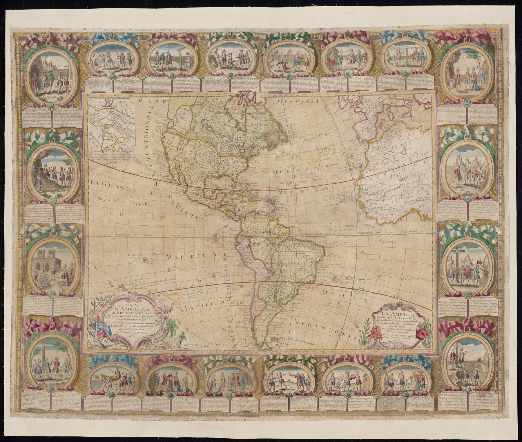
Carte d'Amerique, Divisee en ses Principaux Pays, Dressee sur les Memoires les plus recents, et sur differents Voyages, et assujettie aux observations Astronomiques de Mrs. de l'Academie Royale des Sciences
La America Dividida segun lo dilatado de sus principales partes cuyos puntos principales estan delineados sobre las ultimas observationes
-
Map/Doc
96430
-
Collection
Holcomb Digital Map Collection
-
Object Dates
1787 (Creation Date)
-
People and Organizations
Jean-Baptiste Louis Clouet (Cartographer)
-
Subjects
North America South America
-
Height x Width
43.5 x 51.3 inches
110.5 x 130.3 cm
-
Medium
digital image
-
Comments
Courtesy of Frank and Carol Holcomb.
Part of: Holcomb Digital Map Collection
Map of Texas compiled from surveys recorded in the Land Office of Texas, and other official surveys

Print $20.00
- Digital $50.00
Map of Texas compiled from surveys recorded in the Land Office of Texas, and other official surveys
1843
Size 27.1 x 22.5 inches
Map/Doc 93863
Map of the British Isles designed to accompany Smith's Geography for Schools

Print $20.00
- Digital $50.00
Map of the British Isles designed to accompany Smith's Geography for Schools
1850
Size 12.1 x 9.8 inches
Map/Doc 93894
Tanner's Travelling Map of Mexico

Print $2.00
- Digital $50.00
Tanner's Travelling Map of Mexico
1847
Size 6.2 x 4.1 inches
Map/Doc 93877
Texas (verso)

Print $20.00
- Digital $50.00
Texas (verso)
1833
Size 19.1 x 22.8 inches
Map/Doc 93837
A General Map of North America; In which is Express'd the several New Roads, Forts, Engagements, & c. taken from Actual Surveys and Observations Made in the Army employ'd there

Print $20.00
- Digital $50.00
A General Map of North America; In which is Express'd the several New Roads, Forts, Engagements, & c. taken from Actual Surveys and Observations Made in the Army employ'd there
1761
Size 37.6 x 38.6 inches
Map/Doc 93827
Carte Generale du Royaume de la Nouvelle Espagne depuis le Parallele de 16° jusqu'au Parallele de 38° (Latitude Nord)

Print $20.00
- Digital $50.00
Carte Generale du Royaume de la Nouvelle Espagne depuis le Parallele de 16° jusqu'au Parallele de 38° (Latitude Nord)
1804
Size 41.5 x 29.5 inches
Map/Doc 96510
J. De Cordova's Map of the State of Texas Compiled from the records of the General Land Office of the State

Print $2.00
- Digital $50.00
J. De Cordova's Map of the State of Texas Compiled from the records of the General Land Office of the State
1855
Size 6.8 x 4.0 inches
Map/Doc 93912
Qvarte Partie Dv Monde

Print $20.00
- Digital $50.00
Qvarte Partie Dv Monde
1575
Size 15.3 x 18.9 inches
Map/Doc 93806
Map of Africa designed to accompany Smith's Geography for Schools

Print $20.00
- Digital $50.00
Map of Africa designed to accompany Smith's Geography for Schools
1850
Size 9.7 x 12.0 inches
Map/Doc 93897
Nova et Acurata Totius Americae Tabula

Print $40.00
Nova et Acurata Totius Americae Tabula
1608
Size 40.8 x 56.5 inches
Map/Doc 97019
Map of Europe designed to accompany Smith's Geography for Schools

Print $20.00
- Digital $50.00
Map of Europe designed to accompany Smith's Geography for Schools
1850
Size 9.8 x 12.1 inches
Map/Doc 93892
Carte du Mexique et de la Floride des Terres Angloises et des Isles Antilles du cours et des environs de la Riviere de Mississipi

Print $20.00
- Digital $50.00
Carte du Mexique et de la Floride des Terres Angloises et des Isles Antilles du cours et des environs de la Riviere de Mississipi
1703
Size 19.0 x 25.8 inches
Map/Doc 96519
You may also like
Terrell County Sketch File 22A

Print $20.00
- Digital $50.00
Terrell County Sketch File 22A
Size 21.7 x 11.4 inches
Map/Doc 12422
Coke County Sketch File 4

Print $46.00
- Digital $50.00
Coke County Sketch File 4
1884
Size 9.2 x 7.7 inches
Map/Doc 18566
Freestone County Working Sketch 25

Print $20.00
- Digital $50.00
Freestone County Working Sketch 25
1984
Size 43.5 x 38.4 inches
Map/Doc 69267
Johnson County Sketch File 3

Print $4.00
- Digital $50.00
Johnson County Sketch File 3
Size 10.1 x 8.0 inches
Map/Doc 28433
Flight Mission No. CRK-3P, Frame 129, Refugio County

Print $20.00
- Digital $50.00
Flight Mission No. CRK-3P, Frame 129, Refugio County
1956
Size 18.5 x 22.4 inches
Map/Doc 86917
Flight Mission No. DQO-2K, Frame 101, Galveston County

Print $20.00
- Digital $50.00
Flight Mission No. DQO-2K, Frame 101, Galveston County
1952
Size 18.8 x 22.5 inches
Map/Doc 85028
Texas City Channel, Texas, Channel and Turning Basin Dredging - Sheet 1

Print $20.00
- Digital $50.00
Texas City Channel, Texas, Channel and Turning Basin Dredging - Sheet 1
1958
Size 29.3 x 40.8 inches
Map/Doc 61831
Shelby County Shelby District

Print $20.00
- Digital $50.00
Shelby County Shelby District
1880
Size 20.5 x 25.3 inches
Map/Doc 4030
Shackelford County Working Sketch 12

Print $20.00
- Digital $50.00
Shackelford County Working Sketch 12
1998
Size 27.0 x 22.3 inches
Map/Doc 63852
Upton County Sketch File 43

Print $22.00
- Digital $50.00
Upton County Sketch File 43
1988
Size 11.4 x 8.8 inches
Map/Doc 38920
East Part of Edwards County

Print $40.00
- Digital $50.00
East Part of Edwards County
1975
Size 55.7 x 40.5 inches
Map/Doc 73138
Blanco County Working Sketch 24

Print $20.00
- Digital $50.00
Blanco County Working Sketch 24
1963
Size 30.2 x 31.2 inches
Map/Doc 67384