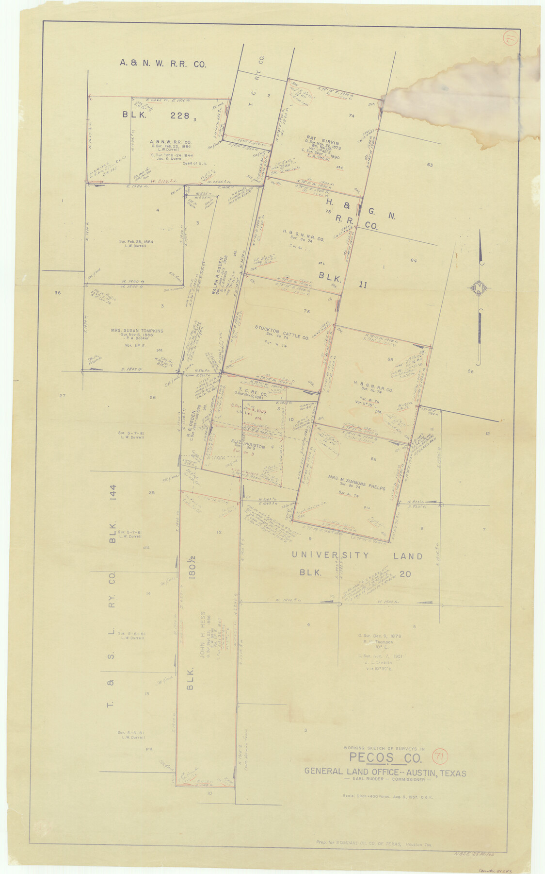
Pecos County Working Sketch 71
-
Map/Doc
71543
-
Collection
General Map Collection
-
Object Dates
8/8/1957 (Creation Date)
-
People and Organizations
Otto G. Kurio (Draftsman)
-
Counties
Pecos
-
Subjects
Surveying Working Sketch
-
Height x Width
41.6 x 26.0 inches
105.7 x 66.0 cm
-
Scale
1" = 400 varas
Part of: General Map Collection
Houston County Rolled Sketch 6

Print $40.00
- Digital $50.00
Houston County Rolled Sketch 6
1963
Size 48.0 x 34.3 inches
Map/Doc 9182
Refugio County Sketch File 16

Print $4.00
- Digital $50.00
Refugio County Sketch File 16
Size 7.1 x 8.2 inches
Map/Doc 35270
Flight Mission No. CUG-1P, Frame 81, Kleberg County

Print $20.00
- Digital $50.00
Flight Mission No. CUG-1P, Frame 81, Kleberg County
1956
Size 18.5 x 22.2 inches
Map/Doc 86146
Castro County Sketch File 17

Print $20.00
- Digital $50.00
Castro County Sketch File 17
1981
Size 14.8 x 25.7 inches
Map/Doc 11063

Wharton County Sketch File 4

Print $20.00
- Digital $50.00
Wharton County Sketch File 4
Size 26.9 x 16.2 inches
Map/Doc 12659
Austin County

Print $20.00
- Digital $50.00
Austin County
1943
Size 40.2 x 43.0 inches
Map/Doc 95422
Sutton County Boundary File 6

Print $10.00
- Digital $50.00
Sutton County Boundary File 6
Size 14.4 x 8.8 inches
Map/Doc 59070
Williamson County

Print $40.00
- Digital $50.00
Williamson County
1888
Size 39.7 x 56.3 inches
Map/Doc 63129
Flight Mission No. BRE-2P, Frame 16, Nueces County

Print $20.00
- Digital $50.00
Flight Mission No. BRE-2P, Frame 16, Nueces County
1956
Size 18.3 x 22.2 inches
Map/Doc 86725
Leon County Sketch File 38

Print $10.00
- Digital $50.00
Leon County Sketch File 38
1999
Size 11.0 x 8.5 inches
Map/Doc 29878
Dimmit County Sketch File 57

Print $6.00
- Digital $50.00
Dimmit County Sketch File 57
1941
Size 14.3 x 8.8 inches
Map/Doc 21190
You may also like
Jim Wells County Working Sketch 8

Print $20.00
- Digital $50.00
Jim Wells County Working Sketch 8
1947
Size 23.8 x 26.0 inches
Map/Doc 66606
Brewster County Rolled Sketch 57

Print $20.00
- Digital $50.00
Brewster County Rolled Sketch 57
1937
Size 43.1 x 37.8 inches
Map/Doc 8482
[Right of Way and Track Map, the Missouri, Kansas and Texas Ry. of Texas - Henrietta Division]
![64758, [Right of Way and Track Map, the Missouri, Kansas and Texas Ry. of Texas - Henrietta Division], General Map Collection](https://historictexasmaps.com/wmedia_w700/maps/64758.tif.jpg)
Print $20.00
- Digital $50.00
[Right of Way and Track Map, the Missouri, Kansas and Texas Ry. of Texas - Henrietta Division]
1918
Size 11.8 x 26.8 inches
Map/Doc 64758
Fannin County Boundary File 9

Print $14.00
- Digital $50.00
Fannin County Boundary File 9
Size 13.2 x 8.8 inches
Map/Doc 53318
Topographic Map of Big Bend Area

Print $20.00
Topographic Map of Big Bend Area
1923
Size 40.1 x 40.3 inches
Map/Doc 79759
Glasscock County Working Sketch 15

Print $40.00
- Digital $50.00
Glasscock County Working Sketch 15
1984
Size 65.6 x 42.1 inches
Map/Doc 63188
Callahan County Sketch File 10

Print $40.00
- Digital $50.00
Callahan County Sketch File 10
Size 21.7 x 24.7 inches
Map/Doc 11039

Hartley County

Print $20.00
- Digital $50.00
Hartley County
1892
Size 25.0 x 20.0 inches
Map/Doc 90670
Brewster County Rolled Sketch RSH

Print $20.00
- Digital $50.00
Brewster County Rolled Sketch RSH
Size 31.9 x 28.3 inches
Map/Doc 5324
Texas Official Travel Map [Major Metropolitan Areas]
![96830, Texas Official Travel Map [Major Metropolitan Areas], General Map Collection](https://historictexasmaps.com/wmedia_w700/maps/96830.tif.jpg)
Texas Official Travel Map [Major Metropolitan Areas]
2008
Size 33.2 x 36.1 inches
Map/Doc 96830
Van Zandt County Sketch File 31

Print $4.00
- Digital $50.00
Van Zandt County Sketch File 31
1860
Size 12.6 x 8.1 inches
Map/Doc 39463