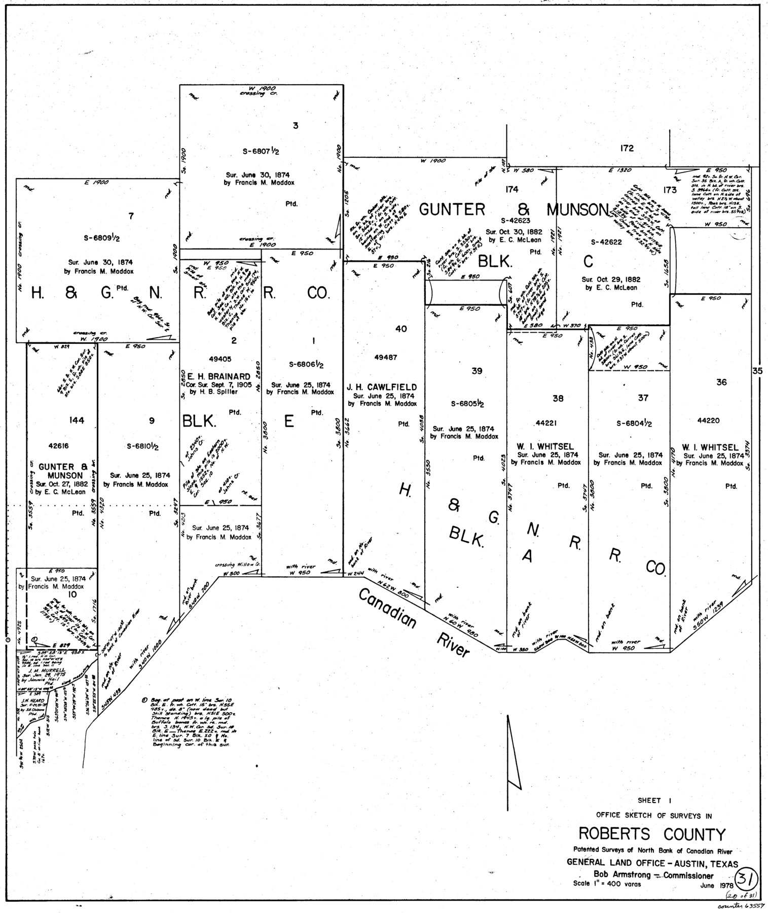
Roberts County Working Sketch 31
-
Map/Doc
63557
-
Collection
General Map Collection
-
Object Dates
6/1978 (Creation Date)
-
Counties
Roberts
-
Subjects
Surveying Working Sketch
-
Height x Width
26.6 x 22.4 inches
67.6 x 56.9 cm
-
Scale
1" = 400 varas
Part of: General Map Collection
Fort Bend County Working Sketch 2

Print $20.00
- Digital $50.00
Fort Bend County Working Sketch 2
1897
Size 18.3 x 28.4 inches
Map/Doc 69208
Crosby County Working Sketch 16

Print $40.00
- Digital $50.00
Crosby County Working Sketch 16
1979
Size 37.4 x 59.3 inches
Map/Doc 68450
Wilson County Boundary File 1

Print $58.00
- Digital $50.00
Wilson County Boundary File 1
Size 9.6 x 4.5 inches
Map/Doc 60058
Orange County - West one half of Sabine River showing leases 5 & 6 traced from U. S. C. & G. S. chart no. 533

Print $20.00
- Digital $50.00
Orange County - West one half of Sabine River showing leases 5 & 6 traced from U. S. C. & G. S. chart no. 533
1957
Size 30.6 x 35.4 inches
Map/Doc 2899
Montgomery County Rolled Sketch 42

Print $20.00
- Digital $50.00
Montgomery County Rolled Sketch 42
1939
Size 13.9 x 20.2 inches
Map/Doc 6820
Atascosa County Sketch File 40

Print $40.00
- Digital $50.00
Atascosa County Sketch File 40
1881
Size 15.2 x 12.6 inches
Map/Doc 13835
Flight Mission No. CLL-1N, Frame 86, Willacy County

Print $20.00
- Digital $50.00
Flight Mission No. CLL-1N, Frame 86, Willacy County
1954
Size 18.4 x 22.1 inches
Map/Doc 87032
Kimble County Sketch File A

Print $20.00
- Digital $50.00
Kimble County Sketch File A
1895
Size 17.9 x 18.7 inches
Map/Doc 11933
Flight Mission No. BRA-6M, Frame 143, Jefferson County

Print $20.00
- Digital $50.00
Flight Mission No. BRA-6M, Frame 143, Jefferson County
1953
Size 18.5 x 22.2 inches
Map/Doc 85444
Starr County Sketch File 44

Print $8.00
- Digital $50.00
Starr County Sketch File 44
1944
Size 14.1 x 8.8 inches
Map/Doc 36995
Matagorda County Rolled Sketch PHL

Print $20.00
- Digital $50.00
Matagorda County Rolled Sketch PHL
1937
Size 37.3 x 40.0 inches
Map/Doc 9476
Brooks County Sketch File 3a

Print $5.00
- Digital $50.00
Brooks County Sketch File 3a
Size 14.2 x 9.5 inches
Map/Doc 16542
You may also like
Right of Way San Antonio and Aransas Pass Railway

Print $4.00
- Digital $50.00
Right of Way San Antonio and Aransas Pass Railway
1919
Size 11.6 x 18.5 inches
Map/Doc 62561
Mills County Sketch File 28

Print $8.00
- Digital $50.00
Mills County Sketch File 28
2000
Size 14.3 x 8.7 inches
Map/Doc 31684

Stonewall County Rolled Sketch 34

Print $20.00
- Digital $50.00
Stonewall County Rolled Sketch 34
Size 37.5 x 30.2 inches
Map/Doc 7878
Baylor County Rolled Sketch 10

Print $20.00
- Digital $50.00
Baylor County Rolled Sketch 10
Size 28.0 x 14.0 inches
Map/Doc 5127
National Map Company's New Road Survey of the United States Showing Main Highways

Digital $50.00
National Map Company's New Road Survey of the United States Showing Main Highways
Size 44.5 x 38.2 inches
Map/Doc 4659
Navigation Maps of Gulf Intracoastal Waterway, Port Arthur to Brownsville, Texas

Print $4.00
- Digital $50.00
Navigation Maps of Gulf Intracoastal Waterway, Port Arthur to Brownsville, Texas
1951
Size 16.6 x 21.3 inches
Map/Doc 65431
Mason County Rolled Sketch 6

Print $20.00
- Digital $50.00
Mason County Rolled Sketch 6
Size 19.5 x 22.2 inches
Map/Doc 6678
Young County Rolled Sketch 16

Print $20.00
- Digital $50.00
Young County Rolled Sketch 16
1982
Size 19.1 x 31.3 inches
Map/Doc 8304
Intracoastal Waterway - Port Arthur to Galveston Bay

Print $20.00
- Digital $50.00
Intracoastal Waterway - Port Arthur to Galveston Bay
1960
Size 26.7 x 38.8 inches
Map/Doc 69832
Hemphill County Working Sketch 38

Print $20.00
- Digital $50.00
Hemphill County Working Sketch 38
1982
Size 29.9 x 27.8 inches
Map/Doc 66133
Trinity River, White Rock Creek Sheet

Print $6.00
- Digital $50.00
Trinity River, White Rock Creek Sheet
1923
Size 33.0 x 24.2 inches
Map/Doc 65198