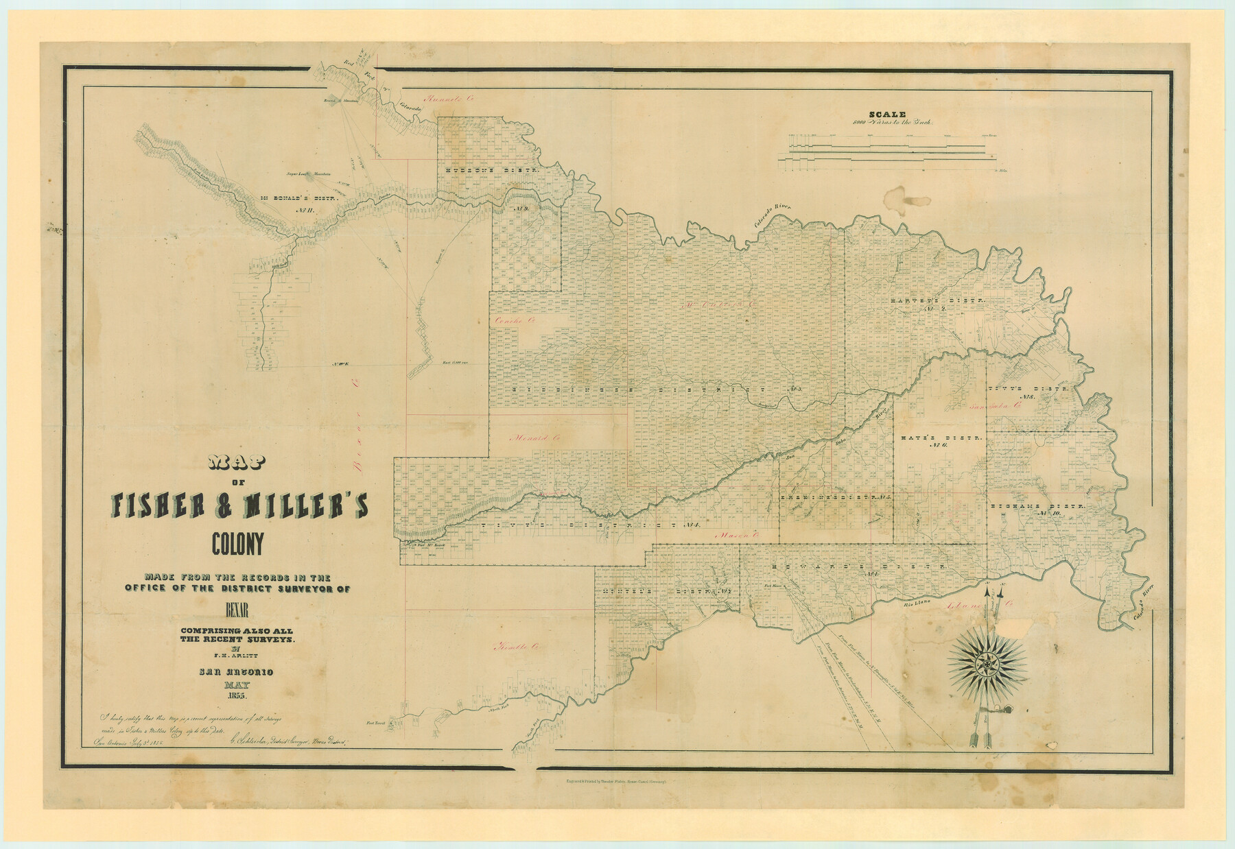
Map of Fisher and Miller's Colony made from the records in the Office of the District Surveyor of Bexar comprising also all the recent surveys
-
Map/Doc
82026
-
Collection
General Map Collection
-
Object Dates
1855 (Creation Date)
-
People and Organizations
Theodor Fisher (Printer)
Gustav Schleicher (Surveyor/Engineer)
F.H. Arlitt (Draftsman)
Anne Jones (Donor)
Jack Jones (Donor)
Kristy Bragg Staats (Donor)
-
Counties
Bexar Concho Menard Kimble Mason McCulloch Runnels San Saba Llano
-
Subjects
Colony
-
Height x Width
27.2 x 39.6 inches
69.1 x 100.6 cm
-
Medium
paper, etching/engraving/lithograph
-
Scale
1:8000
-
Comments
Map donated by Anne and Jack Jones and Kristy Bragg Staats, descendants of D. C. Cowan.
Conservation funded in 2006 by Friends of the Texas General Land Office. -
Features
Hickory Creek
Richland Creek
Simpson Creek
Horse Creek
Rough Creek
China Creek
Bonnet Creek
Marble Creek
San Saba River
Deer Creek
Buffalo Creek
Tiger Creek
Grape Creek
North Concho River
Katemsys Creek
Brady's Creek
Old Spanish Fort
Howard's Creek
Fort McKavett
Elm Creek
Ionia Creek
Bear Creek
Salt Fork [of Leon Creek]
Middle Fork [of Leon Creek]
East Fork [of Leon Creek]
Round Mountain
Honey Creek
Fort Mason
Comanche Creek
Willow Creek
Rio Llano
Fernando Creek
Colorado River
Bluff Creek
Fort Territ
North Fork [of Rio Llano]
South Fork [of Rio Llano]
Leon Creek
Red Fork of Colorado River
Waco Creek
Spring Creek
Mound Creek
Williargers Creek
Elm Creek
Deep Creek
Kicapoo [sic] Creek
Concho River
Sugar Loaf Mountain
South Concho River
Part of: General Map Collection
Jim Wells County Working Sketch 5

Print $20.00
- Digital $50.00
Jim Wells County Working Sketch 5
1942
Size 44.3 x 42.9 inches
Map/Doc 66603
Maps & Lists Showing Prison Lands (Oil & Gas) Leased as of June 1955

Digital $50.00
Maps & Lists Showing Prison Lands (Oil & Gas) Leased as of June 1955
Size 11.4 x 7.1 inches
Map/Doc 62866
Map of Power and Hewetson Colony

Print $20.00
- Digital $50.00
Map of Power and Hewetson Colony
1841
Size 34.8 x 24.3 inches
Map/Doc 1950
Cameron County Sketch File 10

Print $8.00
- Digital $50.00
Cameron County Sketch File 10
1989
Size 11.1 x 8.6 inches
Map/Doc 17205
Presidio County Working Sketch 133

Print $20.00
- Digital $50.00
Presidio County Working Sketch 133
1989
Size 31.7 x 42.8 inches
Map/Doc 71811
Austin County Rolled Sketch 7

Print $47.00
- Digital $50.00
Austin County Rolled Sketch 7
1974
Size 10.4 x 15.3 inches
Map/Doc 42340
Kinney County Sketch File 27

Print $42.00
- Digital $50.00
Kinney County Sketch File 27
1929
Size 32.4 x 13.2 inches
Map/Doc 11946
Stephens County Working Sketch 21

Print $20.00
- Digital $50.00
Stephens County Working Sketch 21
1975
Size 34.7 x 31.9 inches
Map/Doc 63964
Flight Mission No. CGI-1N, Frame 213, Cameron County

Print $20.00
- Digital $50.00
Flight Mission No. CGI-1N, Frame 213, Cameron County
1955
Size 18.5 x 22.2 inches
Map/Doc 84522
Terrell County Rolled Sketch 25

Print $20.00
- Digital $50.00
Terrell County Rolled Sketch 25
1911
Size 15.7 x 22.7 inches
Map/Doc 7932

Kerr County Sketch File 7

Print $4.00
- Digital $50.00
Kerr County Sketch File 7
1881
Size 8.8 x 15.7 inches
Map/Doc 28869
You may also like


Pecos County Sketch File 106

Print $6.00
- Digital $50.00
Pecos County Sketch File 106
1967
Size 14.2 x 8.8 inches
Map/Doc 34030
Hudspeth County Sketch File 34

Print $12.00
- Digital $50.00
Hudspeth County Sketch File 34
1944
Size 11.2 x 8.8 inches
Map/Doc 26997
McLennan County

Print $20.00
- Digital $50.00
McLennan County
1946
Size 43.9 x 46.8 inches
Map/Doc 1887
Johnson County Working Sketch 19

Print $20.00
- Digital $50.00
Johnson County Working Sketch 19
1990
Size 35.2 x 42.5 inches
Map/Doc 66632
Chambers County Rolled Sketch 19

Print $20.00
- Digital $50.00
Chambers County Rolled Sketch 19
Size 39.8 x 44.4 inches
Map/Doc 8588
Montgomery Co.

Print $40.00
- Digital $50.00
Montgomery Co.
1943
Size 44.4 x 54.1 inches
Map/Doc 73244
[Texas & Pacific Railway through Callahan County]
![64233, [Texas & Pacific Railway through Callahan County], General Map Collection](https://historictexasmaps.com/wmedia_w700/maps/64233.tif.jpg)
Print $20.00
- Digital $50.00
[Texas & Pacific Railway through Callahan County]
1918
Size 20.5 x 9.4 inches
Map/Doc 64233
Harris County Working Sketch 56

Print $20.00
- Digital $50.00
Harris County Working Sketch 56
1950
Size 33.2 x 31.6 inches
Map/Doc 65948
Flight Mission No. BRE-2P, Frame 6, Nueces County

Print $20.00
- Digital $50.00
Flight Mission No. BRE-2P, Frame 6, Nueces County
1956
Size 18.6 x 22.6 inches
Map/Doc 86715
Flight Mission No. BRE-2P, Frame 99, Nueces County

Print $20.00
- Digital $50.00
Flight Mission No. BRE-2P, Frame 99, Nueces County
1956
Size 18.5 x 22.3 inches
Map/Doc 86784