Uvalde County Rolled Sketch 16
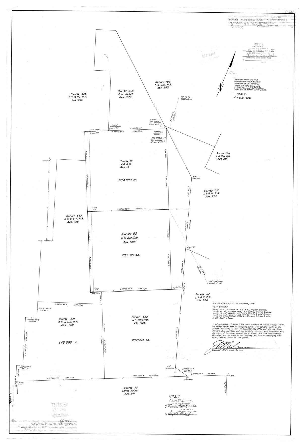
Plat showing survey no. 81, abstract 13, A. B. & M., survey no. 82, abstract 1426, W.D. Bunting, survey no. 581, abstract 769, G. C. & S. F. R.R., surveys no. 582, abstract 1026, N.L. Stratton, Uvalde County, Texas
-
Map/Doc
8100
-
Collection
General Map Collection
-
Object Dates
1978/12/22 (Survey Date)
1979/4/11 (File Date)
-
People and Organizations
James E. Mortensen (Surveyor/Engineer)
-
Counties
Uvalde
-
Subjects
Surveying Rolled Sketch
-
Height x Width
36.6 x 25.1 inches
93.0 x 63.8 cm
-
Scale
1" = 300 varas
Part of: General Map Collection
Motley County Sketch File C (N)

Print $48.00
- Digital $50.00
Motley County Sketch File C (N)
Size 7.7 x 18.4 inches
Map/Doc 31978
Campbell's Addition to El Paso, Texas

Print $20.00
- Digital $50.00
Campbell's Addition to El Paso, Texas
1885
Size 43.5 x 43.1 inches
Map/Doc 8854
Schleicher County Rolled Sketch 12

Print $20.00
- Digital $50.00
Schleicher County Rolled Sketch 12
1952
Size 28.8 x 29.0 inches
Map/Doc 7755
Dallas County Boundary File 6d

Print $104.00
- Digital $50.00
Dallas County Boundary File 6d
Size 14.2 x 8.6 inches
Map/Doc 52229
Johnson County Sketch File 24

Print $4.00
- Digital $50.00
Johnson County Sketch File 24
1873
Size 9.9 x 7.9 inches
Map/Doc 28457
Harrison County Rolled Sketch 5

Print $20.00
- Digital $50.00
Harrison County Rolled Sketch 5
1949
Size 33.7 x 19.3 inches
Map/Doc 6467
Reeves County Working Sketch 46

Print $40.00
- Digital $50.00
Reeves County Working Sketch 46
1974
Size 52.4 x 37.2 inches
Map/Doc 63489
A New Map of the Whole Continent of America. Divided into North and South and West Indies, wherein are exactly decribed the United States of North America as well as the Several European Possessions according to the Preliminaries of Peace…

Print $40.00
- Digital $50.00
A New Map of the Whole Continent of America. Divided into North and South and West Indies, wherein are exactly decribed the United States of North America as well as the Several European Possessions according to the Preliminaries of Peace…
Size 22.0 x 48.7 inches
Map/Doc 95136
Brewster County Rolled Sketch 47

Print $20.00
- Digital $50.00
Brewster County Rolled Sketch 47
1930
Size 18.1 x 41.0 inches
Map/Doc 5223
Topography of the Colorado River in the City of Austin

Print $4.00
- Digital $50.00
Topography of the Colorado River in the City of Austin
1941
Size 18.7 x 29.6 inches
Map/Doc 65326
Irion County Sketch File 17

Print $20.00
- Digital $50.00
Irion County Sketch File 17
Size 26.7 x 40.5 inches
Map/Doc 10617
Cass County Sketch File 24

Print $16.00
- Digital $50.00
Cass County Sketch File 24
1936
Size 13.9 x 8.7 inches
Map/Doc 17436
You may also like
Calhoun County Rolled Sketch 16

Print $20.00
- Digital $50.00
Calhoun County Rolled Sketch 16
1957
Size 33.6 x 33.8 inches
Map/Doc 8549
Howard County Working Sketch 10

Print $20.00
- Digital $50.00
Howard County Working Sketch 10
1962
Size 24.4 x 26.1 inches
Map/Doc 66278
[Field notes, sketch and legislation regarding the National Road from Dallas at the mouth of the Elm Fork of the Trinity to the mouth of Kiamechi on Red River]
![65469, [Field notes, sketch and legislation regarding the National Road from Dallas at the mouth of the Elm Fork of the Trinity to the mouth of Kiamechi on Red River], General Map Collection](https://historictexasmaps.com/wmedia_w700/pdf_converted_jpg/qi_pdf_thumbnail_19857.jpg)
Print $84.00
- Digital $50.00
[Field notes, sketch and legislation regarding the National Road from Dallas at the mouth of the Elm Fork of the Trinity to the mouth of Kiamechi on Red River]
1844
Size 6.8 x 11.2 inches
Map/Doc 65469
The Republic County of Harris. Spring 1842

Print $20.00
The Republic County of Harris. Spring 1842
2020
Size 17.7 x 21.7 inches
Map/Doc 96167
Kleberg County Rolled Sketch 10-33

Print $20.00
- Digital $50.00
Kleberg County Rolled Sketch 10-33
1950
Size 36.5 x 32.1 inches
Map/Doc 9393
General Highway Map, Victoria County, Texas

Print $20.00
General Highway Map, Victoria County, Texas
1961
Size 25.0 x 18.3 inches
Map/Doc 79697
General Highway Map, Angelina County, Texas

Print $20.00
General Highway Map, Angelina County, Texas
1961
Size 25.1 x 18.1 inches
Map/Doc 79349
Pecos County Working Sketch Graphic index - northwest part - sheet A

Print $20.00
- Digital $50.00
Pecos County Working Sketch Graphic index - northwest part - sheet A
1975
Size 42.2 x 42.6 inches
Map/Doc 76663
[F. W. & D. C. Ry. Co. Alignment and Right of Way Map, Clay County]
![64727, [F. W. & D. C. Ry. Co. Alignment and Right of Way Map, Clay County], General Map Collection](https://historictexasmaps.com/wmedia_w700/maps/64727-1.tif.jpg)
Print $20.00
- Digital $50.00
[F. W. & D. C. Ry. Co. Alignment and Right of Way Map, Clay County]
1927
Size 18.6 x 11.7 inches
Map/Doc 64727
Childress County Sketch File 12

Print $22.00
- Digital $50.00
Childress County Sketch File 12
Size 13.3 x 8.7 inches
Map/Doc 18255
Jefferson County Aerial Photograph Index Sheet 6

Print $20.00
- Digital $50.00
Jefferson County Aerial Photograph Index Sheet 6
1953
Size 23.3 x 17.0 inches
Map/Doc 83710
Right of Way and Track Map, Texas & New Orleans R.R. operated by the T. & N. O. R.R. Co., Rusk Branch

Print $40.00
- Digital $50.00
Right of Way and Track Map, Texas & New Orleans R.R. operated by the T. & N. O. R.R. Co., Rusk Branch
1918
Size 24.7 x 56.2 inches
Map/Doc 64243