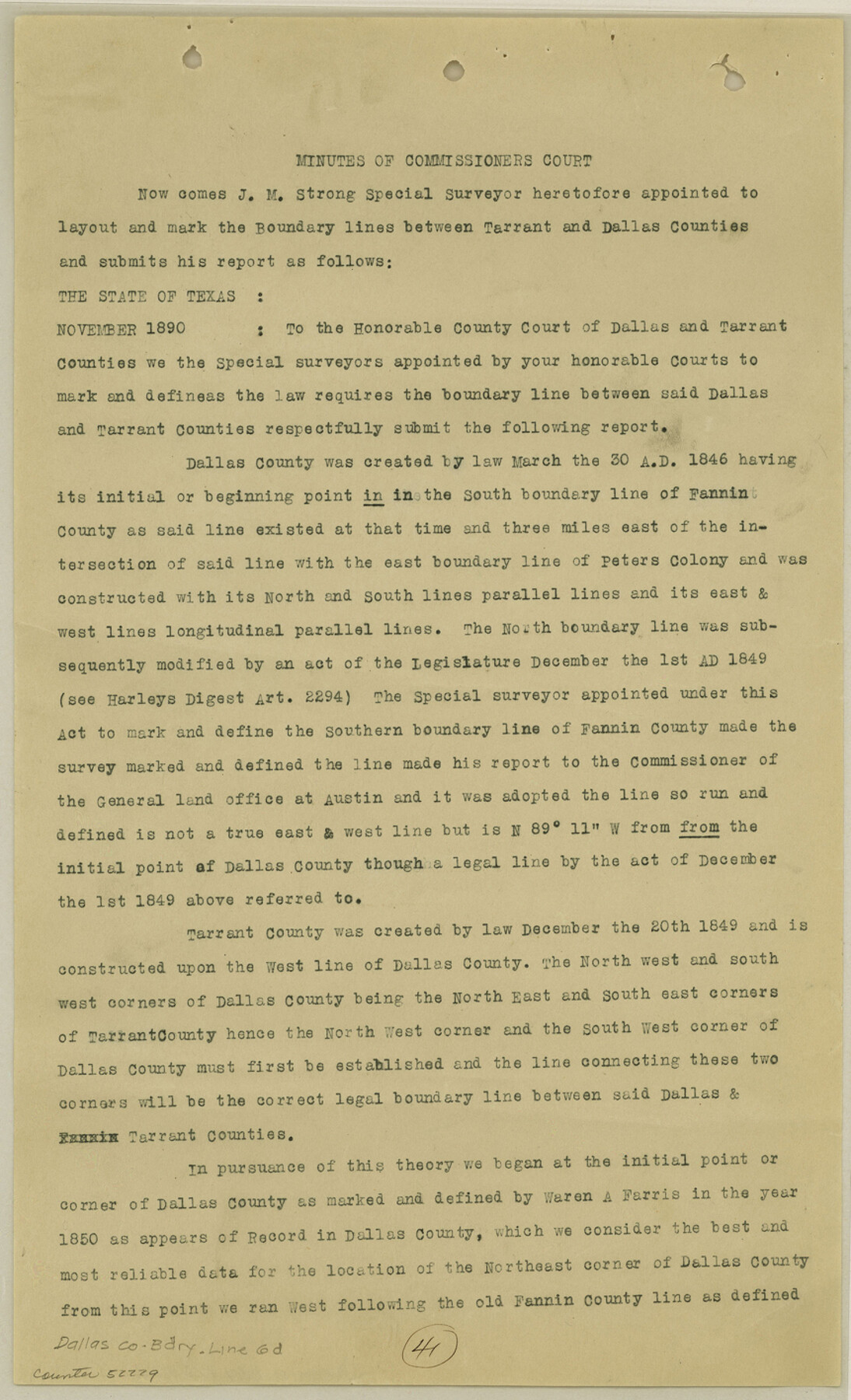
Dallas County Boundary File 6d
[Court Orders regarding Dallas Boundary lines; Fieldnotes on the boundary line between Dallas and Tarrant Counties
-
Map/Doc
52229
-
Collection
General Map Collection
-
Counties
Dallas
-
Subjects
County Boundaries
-
Height x Width
14.2 x 8.6 inches
36.1 x 21.8 cm
Part of: General Map Collection
Haskell County Sketch File 7

Print $22.00
- Digital $50.00
Haskell County Sketch File 7
Size 7.8 x 13.4 inches
Map/Doc 26128
Jefferson County Sketch File 32

Print $4.00
- Digital $50.00
Jefferson County Sketch File 32
1900
Size 11.3 x 8.7 inches
Map/Doc 28195
Dimmit County Sketch File 20a

Print $2.00
- Digital $50.00
Dimmit County Sketch File 20a
Size 9.3 x 4.3 inches
Map/Doc 21103
Flight Mission No. DQO-8K, Frame 16, Galveston County

Print $20.00
- Digital $50.00
Flight Mission No. DQO-8K, Frame 16, Galveston County
1952
Size 18.8 x 22.4 inches
Map/Doc 85139
Denton County Working Sketch 29

Print $40.00
- Digital $50.00
Denton County Working Sketch 29
1987
Size 49.7 x 36.8 inches
Map/Doc 68634
Harris County Sketch File 25

Print $8.00
- Digital $50.00
Harris County Sketch File 25
Size 9.0 x 11.8 inches
Map/Doc 25389
Bee County Sketch File 5

Print $40.00
- Digital $50.00
Bee County Sketch File 5
Size 27.4 x 23.4 inches
Map/Doc 10914
Schleicher County Rolled Sketch 24

Print $20.00
- Digital $50.00
Schleicher County Rolled Sketch 24
Size 29.1 x 15.9 inches
Map/Doc 7763
Haskell County

Print $20.00
- Digital $50.00
Haskell County
1888
Size 38.5 x 37.1 inches
Map/Doc 4700
Matagorda County Sketch File 39

Print $20.00
- Digital $50.00
Matagorda County Sketch File 39
Size 31.1 x 24.3 inches
Map/Doc 12047
Denton County Working Sketch 12

Print $20.00
- Digital $50.00
Denton County Working Sketch 12
1960
Size 29.8 x 17.3 inches
Map/Doc 68617
Brazoria County Working Sketch 30

Print $20.00
- Digital $50.00
Brazoria County Working Sketch 30
1974
Size 37.5 x 43.8 inches
Map/Doc 67515
You may also like
Topographical Map of the Rio Grande, Sheet No. 22

Print $20.00
- Digital $50.00
Topographical Map of the Rio Grande, Sheet No. 22
1912
Map/Doc 89546
Flight Mission No. BQY-4M, Frame 32, Harris County

Print $20.00
- Digital $50.00
Flight Mission No. BQY-4M, Frame 32, Harris County
1953
Size 18.6 x 22.6 inches
Map/Doc 85247
Grayson County Working Sketch 8

Print $20.00
- Digital $50.00
Grayson County Working Sketch 8
1944
Size 19.8 x 16.7 inches
Map/Doc 63247
[Capitol Land Leagues and Blocks M6, 10T, T1, O5 and part of Block B]
![93194, [Capitol Land Leagues and Blocks M6, 10T, T1, O5 and part of Block B], Twichell Survey Records](https://historictexasmaps.com/wmedia_w700/maps/93194-1.tif.jpg)
Print $40.00
- Digital $50.00
[Capitol Land Leagues and Blocks M6, 10T, T1, O5 and part of Block B]
Size 43.7 x 105.6 inches
Map/Doc 93194
Map of Bexar County

Print $40.00
- Digital $50.00
Map of Bexar County
1887
Size 46.1 x 48.6 inches
Map/Doc 16942
Culberson County Sketch File 22

Print $6.00
- Digital $50.00
Culberson County Sketch File 22
1934
Size 11.8 x 8.8 inches
Map/Doc 20234
Bastrop County Working Sketch 14

Print $20.00
- Digital $50.00
Bastrop County Working Sketch 14
1984
Size 24.5 x 23.4 inches
Map/Doc 67314
[Sketch between Wheeler County and Oklahoma]
![89674, [Sketch between Wheeler County and Oklahoma], Twichell Survey Records](https://historictexasmaps.com/wmedia_w700/maps/89674-1.tif.jpg)
Print $40.00
- Digital $50.00
[Sketch between Wheeler County and Oklahoma]
Size 64.9 x 10.2 inches
Map/Doc 89674
Nacogdoches County Working Sketch 10

Print $20.00
- Digital $50.00
Nacogdoches County Working Sketch 10
1981
Size 19.0 x 17.6 inches
Map/Doc 71226
Flight Mission No. BQY-15M, Frame 9, Harris County

Print $20.00
- Digital $50.00
Flight Mission No. BQY-15M, Frame 9, Harris County
1953
Size 18.6 x 22.2 inches
Map/Doc 85307
Sulphur River, Harts Bluff Sheet

Print $3.00
- Digital $50.00
Sulphur River, Harts Bluff Sheet
1919
Size 13.1 x 18.0 inches
Map/Doc 78329
Motley County Sketch File 15 (N)

Print $20.00
- Digital $50.00
Motley County Sketch File 15 (N)
Size 20.6 x 26.0 inches
Map/Doc 42143