Calhoun County Rolled Sketch 16
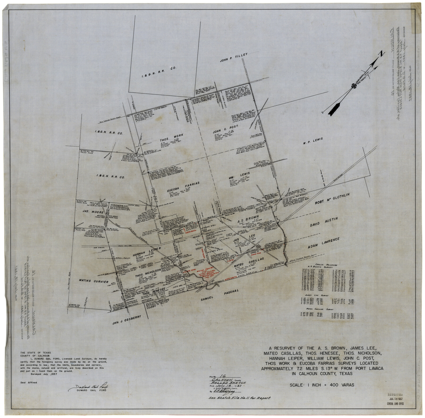
A resurvey of the A.S. Brown, James Lee, Mateo Casillas, Thos. Henesee, Thos. Nicholson, Hannah Leper, William Lewis, John C. Post, Thos. Work & Eucoba Farrias surveys
-
Map/Doc
8549
-
Collection
General Map Collection
-
Object Dates
7/1957 (Creation Date)
7/18/1957 (File Date)
-
People and Organizations
DuWard Gail Ford (Surveyor/Engineer)
-
Counties
Calhoun
-
Subjects
Surveying Rolled Sketch
-
Height x Width
33.6 x 33.8 inches
85.3 x 85.9 cm
-
Medium
linen, manuscript
-
Scale
1" = 400 varas
-
Comments
See Calhoun County Sketch File 11 (35944) for report.
Related maps
Calhoun County Sketch File 11

Print $39.00
- Digital $50.00
Calhoun County Sketch File 11
1957
Size 11.4 x 8.9 inches
Map/Doc 35944
Part of: General Map Collection
Fisher County Sketch File 24

Print $37.00
- Digital $50.00
Fisher County Sketch File 24
1875
Size 14.3 x 8.9 inches
Map/Doc 22666
Childress County Sketch File 11

Print $6.00
- Digital $50.00
Childress County Sketch File 11
Size 14.0 x 8.6 inches
Map/Doc 18253
[Surveys in Milam's Colony along the Colorado River, Onion Creek, Cedar Creek, and north of the San Antonio Road]
![88, [Surveys in Milam's Colony along the Colorado River, Onion Creek, Cedar Creek, and north of the San Antonio Road], General Map Collection](https://historictexasmaps.com/wmedia_w700/maps/88-1.tif.jpg)
Print $20.00
- Digital $50.00
[Surveys in Milam's Colony along the Colorado River, Onion Creek, Cedar Creek, and north of the San Antonio Road]
Size 13.4 x 26.8 inches
Map/Doc 88
Pecos County Sketch File 48

Print $4.00
- Digital $50.00
Pecos County Sketch File 48
1935
Size 14.3 x 8.8 inches
Map/Doc 33762
Flight Mission No. DQN-2K, Frame 93, Calhoun County

Print $20.00
- Digital $50.00
Flight Mission No. DQN-2K, Frame 93, Calhoun County
1953
Size 16.5 x 16.2 inches
Map/Doc 84283
Atascosa County Working Sketch 30

Print $20.00
- Digital $50.00
Atascosa County Working Sketch 30
1980
Size 16.4 x 20.6 inches
Map/Doc 67226
Webb County Rolled Sketch 29

Print $20.00
- Digital $50.00
Webb County Rolled Sketch 29
1932
Size 16.5 x 15.3 inches
Map/Doc 8187
Gaines County Working Sketch 25

Print $20.00
- Digital $50.00
Gaines County Working Sketch 25
1983
Size 37.5 x 38.4 inches
Map/Doc 69325
Smith County Rolled Sketch 7

Print $20.00
- Digital $50.00
Smith County Rolled Sketch 7
2003
Size 46.4 x 35.3 inches
Map/Doc 80141
Texas-Indian Territory Gainesville Quadrangle

Print $20.00
- Digital $50.00
Texas-Indian Territory Gainesville Quadrangle
1902
Size 20.4 x 16.9 inches
Map/Doc 75102
Falls County Sketch File 9

Print $4.00
- Digital $50.00
Falls County Sketch File 9
Size 13.0 x 8.5 inches
Map/Doc 22343
Liberty County Working Sketch 25

Print $20.00
- Digital $50.00
Liberty County Working Sketch 25
1941
Size 24.4 x 19.6 inches
Map/Doc 70484
You may also like
Loving County Rolled Sketch 10

Print $20.00
- Digital $50.00
Loving County Rolled Sketch 10
1990
Size 32.0 x 43.6 inches
Map/Doc 9468
Flight Mission No. CLL-1N, Frame 109, Willacy County

Print $20.00
- Digital $50.00
Flight Mission No. CLL-1N, Frame 109, Willacy County
1954
Size 18.3 x 22.1 inches
Map/Doc 87043
Val Verde County Rolled Sketch 63

Print $20.00
- Digital $50.00
Val Verde County Rolled Sketch 63
1956
Size 37.5 x 41.8 inches
Map/Doc 10082
Anderson County Working Sketch 18

Print $20.00
- Digital $50.00
Anderson County Working Sketch 18
1950
Size 19.9 x 21.2 inches
Map/Doc 67018
Flight Mission No. DQN-1K, Frame 141, Calhoun County

Print $20.00
- Digital $50.00
Flight Mission No. DQN-1K, Frame 141, Calhoun County
1953
Size 18.5 x 22.1 inches
Map/Doc 84204
Reeves County Rolled Sketch 22

Print $20.00
- Digital $50.00
Reeves County Rolled Sketch 22
1960
Size 40.8 x 20.9 inches
Map/Doc 7490
United States of North America (Eastern and Central)

Print $20.00
- Digital $50.00
United States of North America (Eastern and Central)
1862
Size 19.3 x 26.2 inches
Map/Doc 93667
Brewster County Rolled Sketch 127

Print $20.00
- Digital $50.00
Brewster County Rolled Sketch 127
1969
Size 39.0 x 43.8 inches
Map/Doc 8521

Collingsworth County

Print $20.00
- Digital $50.00
Collingsworth County
1880
Size 24.9 x 20.0 inches
Map/Doc 3420
Flight Mission No. DCL-5C, Frame 51, Kenedy County

Print $20.00
- Digital $50.00
Flight Mission No. DCL-5C, Frame 51, Kenedy County
1943
Size 18.5 x 22.2 inches
Map/Doc 85847
Presidio County Sketch File 68

Print $4.00
- Digital $50.00
Presidio County Sketch File 68
1941
Size 11.2 x 8.8 inches
Map/Doc 34662